All Activity
- Past hour
-
Well, the heat and humidity didn't produce any precip for me either, so I'll gladly take this instead. Low of 47. Spectacular.
-

2025-2026 ENSO
donsutherland1 replied to 40/70 Benchmark's topic in Weather Forecasting and Discussion
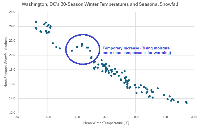
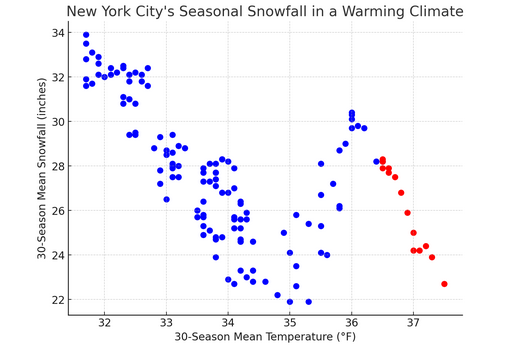
The persisent La Niña state is an important factor. Statistically, the odds of sufficiently cold winters have declined quite a bit. Even with last winter, the warmth was sufficiently great the the historic probability of a 50" season was very low. By the 2040s (maybe earlier if warming is greater than expected) it's possible that 50" winters will be all but gone with 40" winters becoming as rare as 50" winters. I suspect part of the explosive rise in snowfall during the early 2000s through 2015-16 had as much to do with the benefits of increased moisture temporarily exceeding the impact of warming winters. However, my guess is that NYC has now passed the point where the impact of additional warming now exceeds the benefits of increased moisture. That pattern was present in Washington, DC, which has experienced a structural decline in seasonal snowfall. Given New York City's higher latitude (closer proximity to cold air sources), a sharper initial rise makes sense. But this is how things might play out, if the City is in the early stages of a structural decline in seasonal snowfall under slow winter warming (where 40° winters remain relatively uncommon until around 2040). Red dots are the 30-season averages for 2025-26 through 2039-40. Stronger winter warming could bring the 30-season average near or below 20" by the mid-2030s. Internal variability will exist, so there will still be snowy winters. There will also be more frequent duds with less than 10" seasonal snowfall. The back-to-back < 10" winters of 2022-23 and 2023-24 were perhaps a "warning shot" from a future warmer winter climate. -
71 here in Savannah GA. Feels like fall after being in the Keys.
-
The trough is in the Midwest. East coast has South flow next week onwards
-
47.7 in Lancaster for the morning low. .
-
picked up 1/4” yesterday. That brings me to 1.0” for the month we dry
- Today
-
Another cool crisp late August morning just east of HVN at 58°. I really enjoy how well this area near the LI Sound cools off at night compared to the LI South Shore. The low of 51° a few days ago was the lowest August minimum since 2006. These much lower dewpoints allowing for the cooler mornings have been a nice treat following the record June into July heat and humidity. My maxes this month have been +1.8° and my mins have been -1.5°. So the month has been +0.2° so far. Time Series Summary for NEW HAVEN TWEED AP, CT - Month of Aug Lowest Temperature Click column heading to sort ascending, click again to sort descending. 2025 51 2 2024 55 0 2023 58 0 2022 57 0 2021 58 0 2020 57 2 2019 55 0 2018 56 0 2017 55 0 2016 52 0 2015 56 0 2014 56 0 2013 52 0 2012 52 0 2011 55 0 2010 55 0 2009 56 0 2008 54 0 2007 53 0 2006 51 0
-
High yesterday at O'Hare was 70. Perfect weather in the morning, but a few sprinkles in the evening. Finishing up my donuts from the tour yesterday.
-
MoreGarbage. The cold wave will be near 80 all week.
-
0.79" yesterday. Not sure that'll so much to green up the grass Sent from my SM-S921U using Tapatalk
-
GFS has snow into the arrowhead. lol
-
Low of 46 in Marysville. This is awesome for Labor Day weekend & great football weather!
-
-
48.9 low here, 5th morning in a row in 40's, nice!
-
Records: Highs: EWR: 100 (1953) NYC: 98 (1973) LGA: 99 (1953) JFk: 95 (1973) Lows: EWR: 49 (1934) NYC: 50 (1965) LGA: 55 (1986) JFK: 51 (1965) Historical: 1776 - General Washington took advantage of a heavy fog to evacuate Long Island after a defeat. Adverse winds kept the British fleet from intervening. (David Ludlum) 1838 - A major tornado, possibly the worst in Rhode Island history, passed south of Providence. It uprooted and stripped trees of their branches, unroofed or destroyed many houses, and sucked water out of ponds. The tornado barely missed a local railroad depot, where many people were waiting for a train. The tornado injured five people. 1839 - A hurricane moved from Cape Hatteras NC to offshore New England. An unusual feature of the hurricane was the snow it helped produce, which whitened the Catskill Mountains of New York State. Considerable snow was also reported at Salem NY. (The Weather Channel) 1907: Snow fell on Monadnock Mountain in southern New Hampshire. (Ref. Wilson Wx. History) 1915: Some of the chilliest August weather on record occurred from the Plains to the upper Midwest. Locations that reported their all-time coldest temperature for August included: Neillsville, WI: 31°, Rochester, MN: 32° (also earliest first occurrence of freezing temperatures), Fayette, IA: 33°, Winona, MN: 33°, Charles City, IA: 34°, Grand Meadow, MN: 34°, Lancaster, WI: 34°, La Crosse, WI: 35°, New Hampton, IA: 35°, Rockford, IL: 35 °F. (Ref. Wilson Wx. History) 1950: On this date through the 31st, Hurricane Baker made landfall at Santa Rosa Island between Mobile, AL and Pensacola, FL with winds of 100 mph. At Pensacola, the lowest sea-level pressure was 991 millibars or 29.27 inches of mercury at 10 PM with a maximum wind speed of 42 mph from the southeast. A waterspout/tornado came ashore and unroofed a home and store at Apalachicola, FL. 23 homes were damaged. One other tornado was reported in Jackson County. (Ref. AccWeather Weather History) 1953: Five days with 100° or more the 29th to the 2nd at DC -100,103,102,102,101 (Ref. Washington Weather Records - KDCA) 1954: Hurricane Carol strengthened to Category 2 strength off the North Carolina coast with maximum sustained winds near 100 mph. Carol would accelerate over the next 24 hours and make landfall the next day over the Fire Island community of Point O' Woods on the eastern end of Long Island, NY with 100 mph sustained winds. An interesting note from Hurricane Carol was some of the strongest criticism came about the name of the storm. Editorials railed that it was not appropriate to give a nice name like Carol to a destructive hurricane. (Ref. AccWeather Weather History) 1955: Big Meadows had 23.88 inches, VA greatest monthly precipitation total. 1959: Severe thunderstorms moved south across western Oklahoma, leaving several swaths of extensive hail damage. The Weatherford area was especially hard hit. Hail up to golf ball size caused severe damage to roofs and windows on almost all homes and buildings in the Weatherford area. Other hail paths, some of which caused 100% crop damage, extended from Dill City, south to the Red River in Cotton County, over the Grandfield area, and from near Granite to Headrick. The storms continued into north Texas, where wind damage was reported in the Burkburnett, Wichita Falls, Iowa Park, and Henrietta areas. Wind gusts to 75 mph were measured. (Ref. Wilson Wx. History) 1962: Hackberry, LA gets 22 inches of rain in 24 hours to establish the state record. (Ref. AccWeather Weather History) 1965: Canadian high pressure brought another chilly start to parts of the Great Lakes to the Mid-Atlantic and Northeast. Raleigh, NC dropped to 46°; their coldest August reading. Other record lows included: Concord, NH: 32°, Elkins, WV: 37°, Binghamton, NY: 37°, Ste. St. Marie, MI: 38°, Worcester, MA: 38°, Buffalo, NY: 38°, Williamsport, PA: 38°, Beckley, WV: 39°, Hartford, CT: 39°, Roanoke, VA: 43°, Charleston, WV: 45°, Lynchburg, VA: 45°, Richmond, VA: 47°, Boston, MA: 48°, Norfolk, VA: 52°, Charlotte, NC: 53 °F. (Ref. Additional Temperatures Listed On This Link) 1967: Hurricane Katrina crossed the southern tip of Baja California and then traversed almost the entire length of the Gulf of California before making landfall again and rapidly weakening. More than two inches of rain fell in parts of southern California. Two inches fell at La Quinta and the city was cut off for several hours. 150 homes were damaged by floods in Palm Desert and Indian Wells. (Ref. Wilson Wx. History) 1976: Another preview of fall as record lows were recorded across parts of Great Lakes and Ohio Valley. Grand Rapids, MI fell to 39°, the coldest ever recorded during the month of August. Scattered frost occurs in rural areas. Ste. St. Marie, MI: 35°, Detroit, MI: 41°, Muskegon, MI: 41°, Youngstown, OH: 41°, Toledo, OH: 41°-Tied, Dayton, OH: 43 °F. (Ref. Wilson Wx. History) 1979: Hurricane David grew into one of the most intense storms ever to cross the Caribbean Sea. After wiping out the tiny island of Dominica with 150 mph winds, David crashed ashore in the Dominican Republic at peak intensity on this date, with wind gusts over 200 mph. The central pressure in the storm was at its lowest at 924 millibars or 27.29 inches of mercury. More than 1,200 people on the two-nation island were killed and over 80,000 were left homeless. Damage totaled more than $1 billion dollars in the Caribbean alone. Skipping through the Bahamas, David struck a glancing blow on Florida, just north of the Gold Coast, tore across Cape Canaveral and then moved up the East Coast on September 6th, downing trees and power lines well into New England. 1982 - A tropical depression brought torrential rains to portions of southern Texas. Up to twelve inches fell south of Houston, and as much as eighteen inches fell southeast of Austin. The tropical depression spawned fourteen tornadoes in three days. (David Ludlum) Record cold gripped the northeastern U.S. Thirty-one cities in New England reported record lows, and areas of Vermont received up to three inches of snow. (The Weather Channel) 1985: Massive evacuations were ordered for beach front communities along the northern Gulf Coast as Hurricane Elena made her move toward the coast just before a busy Labor Day weekend. A cold front approached from the northwest, which collapsed the steering currents around Elena, and the storm began to recurve. It approached Florida, moving quite close to Tampa Bay and Cedar Key, before high pressure bridged the frontal boundary and steered Elena back towards the west. Elena intensified as it accelerated west-northwest, and was a major hurricane by the afternoon on September 1st peaking later that day at 125 mph. The hurricane made landfall near Biloxi, MS on September 2 as a major hurricane with maximum sustained winds near 120 mph. Rainfall ranged from 2 inches at Key West to 11 inches at Apalachicola. 1987 - Eight cities in California and Oregon reported record high temperatures for the date, including Redding CA and Sacramento CA where the mercury hit 100 degrees. (The National Weather Summary) 1988 - Thunderstorms drenched Georgia and the Carolinas with heavy rain, soaking Columbia, SC, with 4.10 inches in three hours. Fresno CA was the hot spot in the nation with a record high of 109 degrees. Duluth MN tied their record for the month of August with a morning low of 39 degrees. (The National Weather Summary) 1989 - Thunderstorms developing ahead of a cold front produced large hail in Montana and North Dakota during the evening and early nighttime hours. Hail three inches in diameter was reported 20 miles south of Medora ND, and thunderstorms over Dawson County MT produced up to three inches of rain. Thunderstorms produced golf ball size hail at Roundup MT, Dazey ND and Protection KS. (The National Weather Summary) (Storm Data) 1993: Three people were hurt by lightning in Kalamazoo County, Michigan. Two of them were huddled under an umbrella on the side of a road, watching a wrecker operator connect their stalled vehicle to his tow truck. Lightning struck the umbrella and then traveled to the wrecker operator. (Ref. Wilson Wx. History) 2000: Little Rock, Arkansas: The temperature rises to 111 °F at the North Little Rock Airport, setting a new record for the hottest temperature ever observed at the location. (Ref. WxDoctor) 2001: Thunderstorms developed over northern Illinois during the evening hours. A series of thunderstorms moved across northern Cook County, dumping torrential amounts of rainfall. Flooding was reported on portions of the Kennedy and Edens expressways. The 93 mile deep tunnel was filled to capacity with 1.6 billion gallons of water forcing the Wilmette licks to be opened to dump 75 million gallons of storm and sewer water directly into Lake Michigan. O'Hare Airport received 4.31 inches of rain, most of which fell between 9 pm and 11 pm. This rainfall brought the total for the month to 12.25 inches, making this the second wettest month on record for Chicago. (Ref. Wilson Wx. History) 2003: Lightning struck and killed a man at Busch Gardens near Williamsburg, VA . (Ref. Lightning - Virginia Weather History) 2004": At landfall the storm, Gaston was originally classified as just shy of hurricane strength. While wind damage in South Carolina was minimal, the slow-moving storm produced five to ten inches of rain along its path, causing extensive flooding. Gaston moved north over land, weakening to a tropical depression but still bringing torrential rain to central Virginia, where at least eight people were killed in the ensuing floods. Richmond International Airport had 6.68 inches, Ashland recorded 10.61 inches, including 4.33 inches in one hour. The Richmond (West End ) reported 12.60 inches of rain and Mechanicsville had 10.70 inches. The Shockoe Bottom entertainment district near downtown Richmond was devastated by the flooding. Total damage was estimated at about $130 million. Ref. (Weather Underground Hurricane History Archives - Gaston) 2008: Hurricane Gustav set the world record for the highest wind gust measured in a tropical cyclone with a reading of 211 mph measured in Paso Real de San Deigo, Cuba. “The wind peaked and the anemometer mast fell over sharply interrupting the measurement…” (Weather Guide Calendar with Phenomenal Weather Events 2011 Accord Pub. 2010, USA) 2011: Even before Hurricane Irene dumped rain on the Northeastern United States over the weekend, parts of New England were very soggy. The rain gauge at John F. Kennedy International Airport in New York recorded 7.8 inches (19.8 cm) on Aug. 14, breaking the previous daily record of 6.27 inches (15.9 cm), set in 1984. Before Irene, Robinson told LiveScience, New Jersey was having its sixth-wettest August since statewide records started in 1895. Then Irene moved in as the second-largest rainstorm in the state since 1895. Preliminary estimates peg New Jersey's August rainfall at 16.5 inches (41.9 centimeters), making it the rainiest month ever recorded in the state. (Ref. LifeScience.Com)
-
“Cold wave” It was chilly out there this morning, but Bradford didn’t even break a record.
-
We're almost to December ! Then sun angle is up up up!
-
It's hard not to be pessimistic when my last good winter was 2019, and last winter not working out despite lots of chances really sucked. Oh, and Pensacola, FL getting a great snowstorm when we didn't!
-
Summer is unfortunately dead. It’s like one wet, dewy day next Friday ahead of the next cold front. Yeah maybe we start getting AN again toward mid month, but we’ll be like a week from the equinox and climo norms are tanking. Meh.
-
The other important thing to mention is that there have only been 2 La Nina winters for NYC in the last 50 years with 50”+ in NYC. These were 1995-1996 and 2010-2011. The NYC winter average temperature in 1995-1996 was 32.2° and in 2010-2011 was 32.8°. Both those winters occurred before the warming jump over the last 10 years. The current 10 winter average temperature in NYC since 2015-2016 is the highest on record at 38.2° and +1.8° over the previous warmest 10 winter run. So the past winter which was the coldest of the last decade was only 34.8°. This was 2.0°+ warmer than the 1995-1996 and 2010-2011 winters. I bring up the La Niña factor since we have been in a persistent La Niña background state through the record warming of the WPAC. So this has been interfering with allowing a true El Niño modoki state like we had in 2009-2010 which was a little an over freezing at 33.8°. So the modoki allowed for the heavier snows during a warmer winter than the 2 La Ninas in 1995-1996. The record warming WPAC prevented the El Niño modoki from forming in 2018-2019 and 2019-2020. Even the snowy La Niña winters of 17-18 and 20-21 were too warm for NYC to make it to 50”. But outlying areas which have different requirements to reach 50” did. So my guess is that this current much warmer regime will make it challenging for NYC Central Park station to reach 50” again. But outlying stations which get colder could possibly do it.
-
This 30-day change map suggests that a lot of the cooling in the N Atlantic has been in the last 30 days...Irene?
-
Lowest region 3.4 SSTAs since the tail end of last winter….


.thumb.png.800d51f5f9a328fc73a977dea19e31e4.png)


.thumb.png.f606d4250ee18e5d21e3de2499bc47b4.png)