All Activity
- Past hour
-
UKIE Cyclone
-

2/22-23 "There's no way..." Storm Part 2
SomeguyfromTakomaPark replied to Maestrobjwa's topic in Mid Atlantic
I think dc getting more than 4-6 inches is getting more and more unlikely but this is a very dynamic system and I think sundown tomorrow could be very fun even if just for a few hours. -
I think one could argue the h5 is a tick better on the UKMET. I think the soundings are better than the pivotal ptype suggests. Metros seem to be at 33F under heavy rates, feel like that would accumulate. Verbatim wetter for both metros.
-

2/22-23 "There's no way..." Storm Part 2
Stormchaserchuck1 replied to Maestrobjwa's topic in Mid Atlantic
It's actually not a big anomaly, because we have a 50/50 low and strong Gulf of Alaska 500mb low. NAO is technically positive, but there is ridging left over from the previous -NAO over the Hudson bay/E Canada, with a trough underneath of it. -

“Cory’s in NYC! Let’s HECS!” Feb. 22-24 Disco
Prismshine Productions replied to TheSnowman's topic in New England
One of these days me and you up to Astronomer will rake while EoR gets screwed... One of these days Sent from my SM-S166V using Tapatalk -
Feb 2006 was a hostile pattern as far as I remember.
-
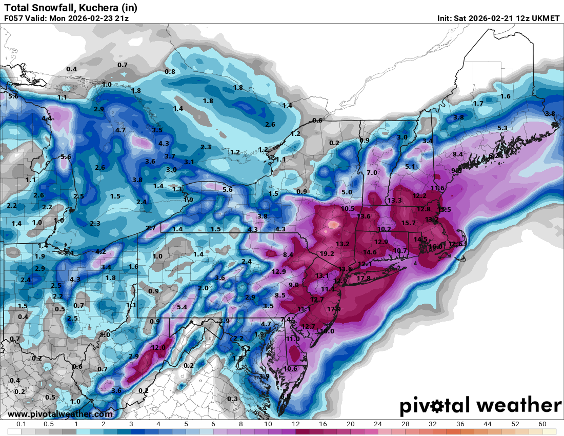
2/21 12z UKMET Total QPF 2/22-2/23- 24 Snow 10:1
-
Isn't there going to be a western ridge spike, aka +PNA?
-

2/22-23 "There's no way..." Storm Part 2
TowsonWeather replied to Maestrobjwa's topic in Mid Atlantic
The Euro has budged a TON. Honestly, what models have you been watching?? The GFS basically had this solution days ago - what it’s showing now is a slightly more eastern version of the same bomb cyclone it showed from several days ago. The Euro has been gradually continuing a shift of several hundred miles and a radically different synoptic evolution that it kept insisting on long after other models had started trending to the GFS. Any attempt to portray the last several days of model output otherwise is pure gaslighting. -
The 14z experimental NBM V5.0:
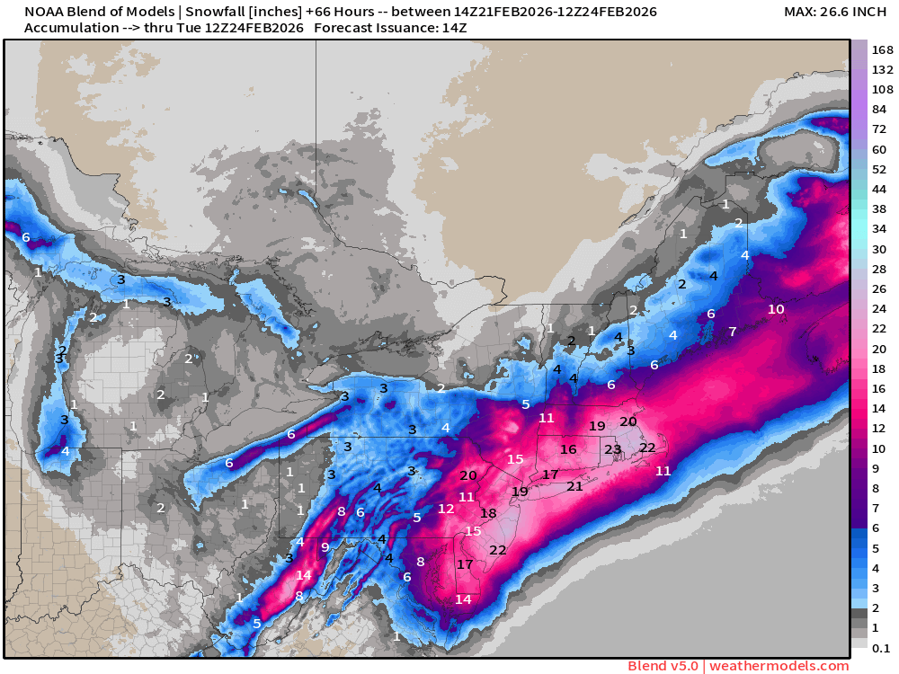
-
Super thanks to you and all the other mets who contribute here!
-
Ukie playing a methodical yet slow game of catch up. .
-

Central PA Winter 25/26 Discussion and Obs
Mount Joy Snowman replied to MAG5035's topic in Upstate New York/Pennsylvania
We ride the RAP until it dies, for this day and all our days! Freedom!!! *whispers quietly that the RAP also shifted east* -

“Cory’s in NYC! Let’s HECS!” Feb. 22-24 Disco
TauntonBlizzard2013 replied to TheSnowman's topic in New England
2.5” liquid here on the gfs lol. Silly -
Today looks to be the day I finally got 40! Already 39.4°F
-
Ukie looks great

-
UKIE amped up a bit
-
so we currently have a -PNA and +NAO, and yet we have a 970mb low crawling up the coast with blizzard warnings in NYC. When was the last time something like that happened?
-
Sorry to hear that Mike - but we do thank you for your service!!
-
Not saying it cause it’s a bomb but RAP has been great only model to pick up on the sleet line stalling at Long Island sound
-

“Cory’s in NYC! Let’s HECS!” Feb. 22-24 Disco
SouthCoastMA replied to TheSnowman's topic in New England
The Jan 2005 AFDs were probably his best -
Track / speed more crucial on the 12z suite all looking good - great. RGEM/ICON AIGFS a bit quicker than GFS/NAM. The QPF will be better honed in on later 18z/00z and tomorrow with meso models. At the time Nam/GFS more robust but banding likely under done on the globals in general. There will likely (as occurs in these rapidly developing storms) bands that drop 0.5 or more in 2-3 hours / 3 - 6 inches of snow.
-

Central PA Winter 25/26 Discussion and Obs
canderson replied to MAG5035's topic in Upstate New York/Pennsylvania
My final prediction, and remember I’m an idiot: MDT: 2.9” LNS: 5.2” @MAG5035: 3.4” @WmsptWx: 3.2” CTP: 3.5” PHL: 9.7” NYC: 11.5 -
GFS and GGEM are both really solid with some good banding potential in the interior. Would love for the euro to tick wetter again at 12z
-
You have the job I (and probably half the forum) wanted. I mean who tf takes diffeq, calc3 and 3 sems of physics and goes into IT, smh lol. Hope you’re right…euro has been stubborn so far.


(002).thumb.png.6e3d9d46bca5fe41aab7a74871dd8af8.png)

