All Activity
- Past hour
-
Things a junk model…so bad now. It’ll flap right up to go time.
- Today
-
Ok . So brings some of the precip back in then?
-
What now?
-
yup looks like most of SNE gets a good drink
-

Central PA Fall Discussions and Obs
Jns2183 replied to ChescoWx's topic in Upstate New York/Pennsylvania
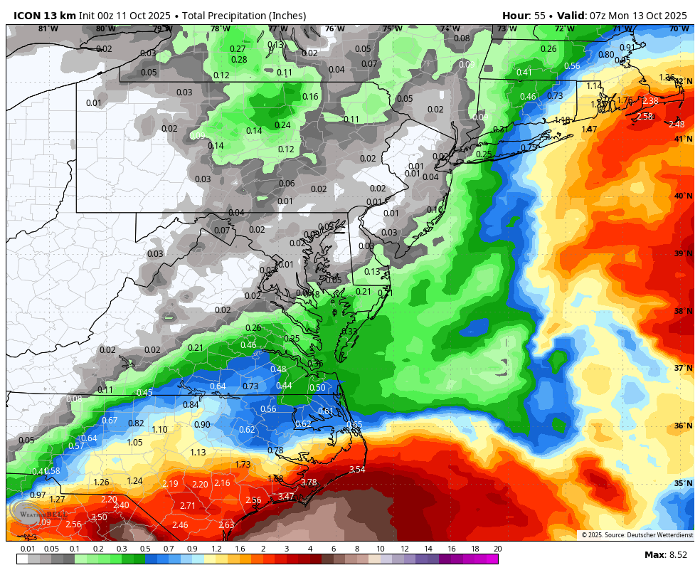
I am amazed at the variation in model rainfall outputs for this storm. By Monday at noon the range is 0.1" to 2.0". Further they each have the storm doing something different and run to run consistency is horrible. I hope this is not a preview of how the models will be this winter. Sent from my SM-G970U1 using Tapatalk -
Euro flapping around more than a fish out of water
-
 Surprised nobody posted the 0Z Euro - just a slight increase in QPF vs. the last run, lol. The rumors of this storm's death have been greatly exaggerated to paraphrase Mark Twain.
- 234 replies
-
- 1
-

-
- heavy rain
- damaging wind
- (and 2 more)
-
We can agree on this.
-
This storm is a pain in the ass! Hopefully the coastals we get this winter don’t have as many moving pieces
-

The return of the elusive Nor'easter. Drought buster or bust?
Amped replied to dailylurker's topic in Mid Atlantic
00z Euro brought the storm back for NYC and NJ at least. We're still SOL. -

E PA/NJ/DE Autumn 2025 Obs/Discussion
LVblizzard replied to PhiEaglesfan712's topic in Philadelphia Region
Still a ton of disagreement on the 0z models about the timing and intensity of this storm, despite the start of it being 1-2 days away. If this was winter this place would be going insane right now. -

The return of the elusive Nor'easter. Drought buster or bust?
Ji replied to dailylurker's topic in Mid Atlantic
Gfs is basically a shutout -
It’s fatiguing to stand in after a while. I’ve done it on mountain summits, but on the shore for Gloria, Bob and several Nor’Easters including Jan 2005 blizzard in Boston. There’s nothing like standing on the beach with high sustained winds.
-
For a Nina pattern the Gulf of Mexico has been dormant,other than TS Barry hitting the Bay of Campeche in late June there has been notta,that hasnt happened since 1991,You'd think we'd have an active S/Jet this winter,severe/cold,who knows
-
The return of the elusive Nor'easter. Drought buster or bust?
Amped replied to dailylurker's topic in Mid Atlantic
There's an inverted troff south of bermuda that is causing all the difference on model runs. The gfs and American models show it slowly moving north and dispersing it while the main coastal moves up into NC/VA. Non-American models are showing it quickly moving northwest and forming into a second low pressure somewhere well east of NC which shreds the other low closer to the Carolina coast One of the smaller features I've ever seen cause chaos in a forecast. Edit: 00z GFS initialization looks further west with that feature. It might be caving in.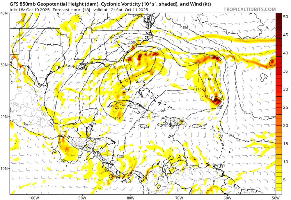
-

Spooky Season (October Disco Thread)
WxWatcher007 replied to Prismshine Productions's topic in New England
Get well soon -
I’m not even following this convo lol. Either way, it’s been cold. I had a heart ablation this week and for some reason the cold really makes me feel the heart pounding. Not pleasant
-
Meh, doesn’t drop south enough I’m sure we can do better for our required .1 inches of October snow (as the average always occurs)
-

"Potentially" powerful Nor'easter Sun-Mon 10/12-13/25 with needed rain-especially south of I84, and fairly high impact sct coastal gusts 50+ MPH and possibly moderate or greater coastal flooding at the midday Sun and Monday high tide cycles.
Wxoutlooksblog replied to wdrag's topic in New York City Metro
It certainly doesn't look like the big wound up powerful nor'easter we saw on the maps yesterday though a few of the models still drench us and kick up the winds. My gut feeling is the dry air works down from the north and that the low center at some point makes a righthand turn before the heavier rainfall is able to win out. I'm sure we'll get some rainfall and some wind gusts but to me at this point it looks manageable. WX/PT- 234 replies
-
- 1
-

-
- heavy rain
- damaging wind
- (and 2 more)
-

The return of the elusive Nor'easter. Drought buster or bust?
Weather Will replied to dailylurker's topic in Mid Atlantic
WB OZ ICON is a whiff.
-
 I suggest you read the actual legislation, prior to what will soon become common knowledge. SOE declarations are an avenue for misappropriation of funds, and this has only emboldened those in power to declare them more frequently. While they absolutely do open the doors for federal funding, they simultaneously allow for interstate funding to be reallocated. It's not what you may believe it is. It occurs across party lines.
 -

October Medium/Long Range Discussion
NorthArlington101 replied to Eskimo Joe's topic in Mid Atlantic
18z GFS is dangerously close to launching the Digital Snow Thread at 384… -
 Eps at 18z had some clusters to the left of placed center .
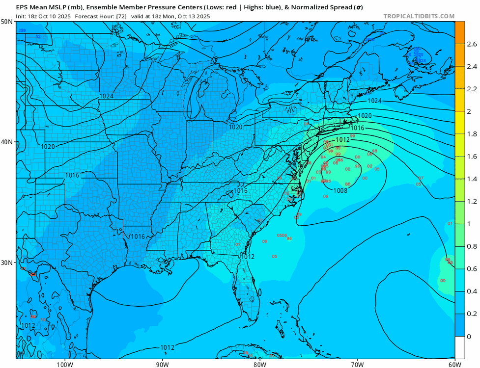
-

The return of the elusive Nor'easter. Drought buster or bust?
high risk replied to dailylurker's topic in Mid Atlantic
Seems to be setting up a regional model vs global model battle. Good to see multiple CAMs in the 00Z suite give much of us at least 0.5" out of this event. -
Oh it’s a lot of fun lol


.thumb.png.4150b06c63a21f61052e47a612bf1818.png)