All Activity
- Past hour
-

12/14: Sunday funday? Will the south win again?
NorthArlington101 replied to TSSN+'s topic in Mid Atlantic
GEFS is a tick NE with the best stuff - that's my biggest worry for MBY... losing this to PHL-NYC -

12/14: Sunday funday? Will the south win again?
dailylurker replied to TSSN+'s topic in Mid Atlantic
To be fair. Most Decembers none of us see a flake lol. I think we're spoiled with this pattern and we forgot how shitty December usually is. -

Minor snow possible sunday 12/14/25
brooklynwx99 replied to WeatherGeek2025's topic in New York City Metro
just a classic post-2016 NYC metro subforum exchange about the RGEM lmao -
December 2025 regional war/obs/disco thread
brooklynwx99 replied to Torch Tiger's topic in New England
gotta love the GFS suite
-

Central PA Winter 25/26 Discussion and Obs
Summit Snow replied to MAG5035's topic in Upstate New York/Pennsylvania
Picked up another 3" up here yesterday. No rain mix due to elevation. Snow squalls and snow showers incoming. Definitely has been an old fashioned start to winter along the Northern Tier this December.
-
What sux is the lack of a forum wide storm.
-
I meant unexpected with regard to the main model MJO projections we follow. None of them on any day’s run had it going into 6 then.
-

Minor snow possible sunday 12/14/25
jm1220 replied to WeatherGeek2025's topic in New York City Metro
We’re not getting that with this setup-it’s too fast and progressive, and the PV is pressing south. We have to hope for a slightly steeper ridge out west that can allow for our system to dig a little more and amplify. But in the end there’s a ceiling of probably what the RGEM or NAM have since this will be in and out in a hurry. -

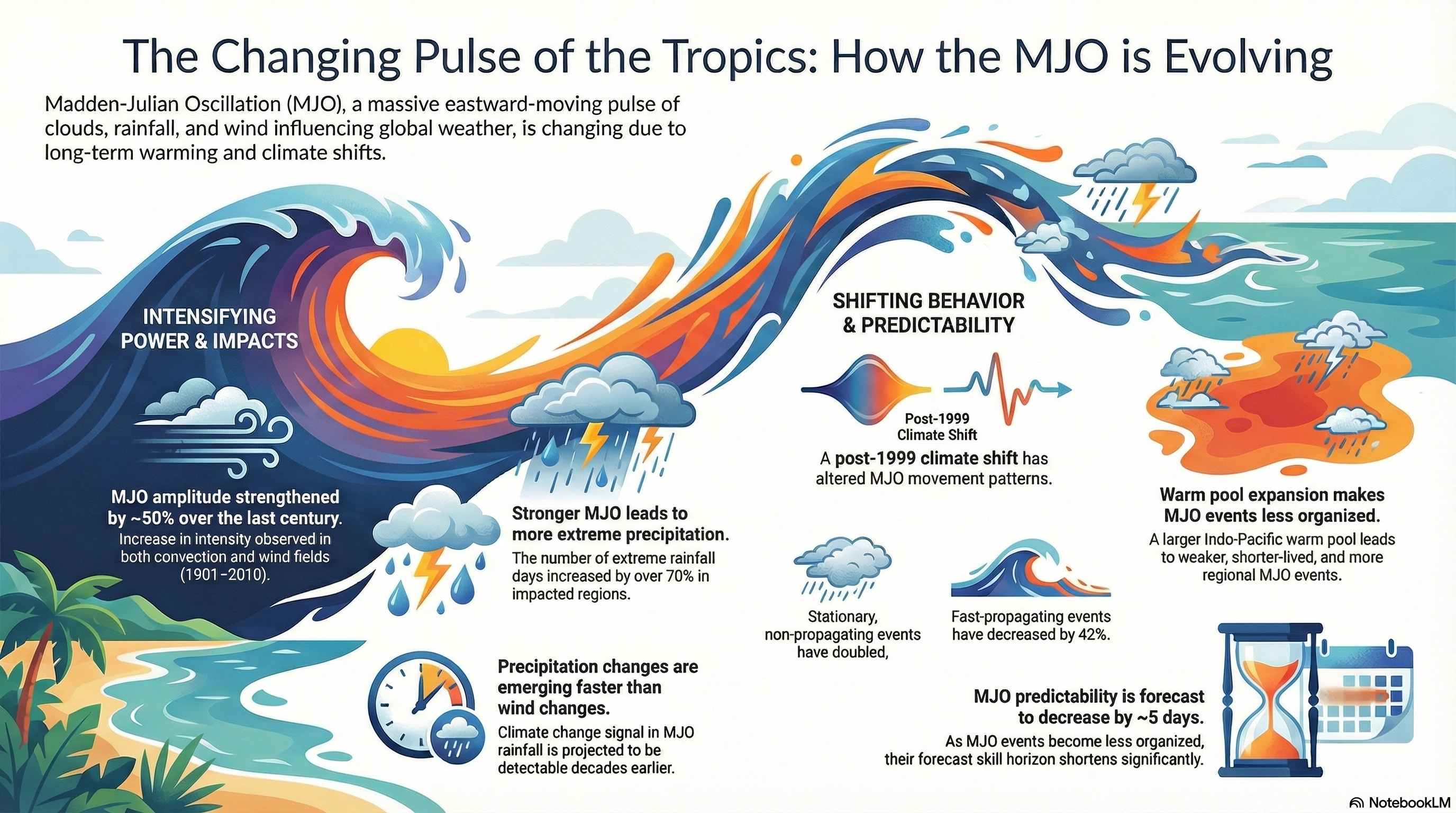
Occasional Thoughts on Climate Change
donsutherland1 replied to donsutherland1's topic in Climate Change
I put a number of papers on how climate change has affected the MJO (many thanks to @bluewave for providing links in a number of posts/threads) and used Notebook LM to generate an infographic. That infographic is based solely on the literature. It is below: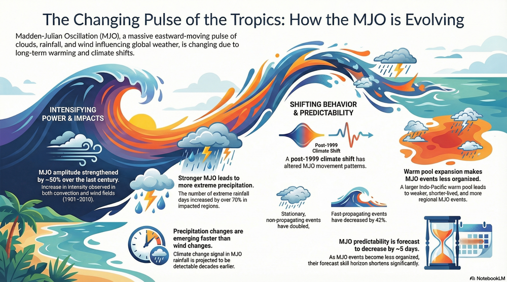
-

Minor snow possible sunday 12/14/25
eduggs replied to WeatherGeek2025's topic in New York City Metro
The RGEM clearly has less precipitation than the NAM. The RGEM is around 0.3 liquid for the greater metro area with a little more in C/SNJ and a little less in NWNJ and SENY. The NAM is double that... around 0.6 liquid for all of the metro, LI, and NENJ, with less north and south. The NAM (likely overdone) is a great run. The RGEM is a good run. Both were encouraging relative to last night's runs. -
I do
-

Central PA Winter 25/26 Discussion and Obs
WmsptWx replied to MAG5035's topic in Upstate New York/Pennsylvania
Cold and gray here today. Would like some sunshine for moral support. -
Persistent flurries/light snow from the low stratus kept temps relatively mild overnight. Only made it down to 12F
-
Nighttime is definitely more productive upslope and my theory has always been it has to do with the developing nocturnal inversion that happens at night. It tends to allow for a more concentrated band of low level snow. Daytime heating tends to disrupt it to some degree (of course unless it is just a monster set up and moisture/wind overpowers it, ie northern Greens)... I feel like the most concentrated upslope bands occur once the nocturnal inversion tries to set in aloft, trapping moisture in the low levels too, enhancing the terrain's influence further... while daytime heating causes it to go more cellular or convective showers.
-
Somehow always flips around Christmas and then finally full flips back to a favorable pattern in March
-
12/14: Sunday funday? Will the south win again?
NorthArlington101 replied to TSSN+'s topic in Mid Atlantic
No way to know what's correct right now. Sure we all have our preferences - and we're all still in the game. Fingers crossed for an outcome that benefits as many folks as possible. -

December 2025 regional war/obs/disco thread
weatherwiz replied to Torch Tiger's topic in New England
This deserves post of the year -

Central PA Winter 25/26 Discussion and Obs
mahantango#1 replied to MAG5035's topic in Upstate New York/Pennsylvania
I know some people criticize that model, but other ones have problems too. But maybe we should ride the NAM till the wheels fall off. -
Makes perfect sense since they both ended up in the Mid-Atlantic!
-
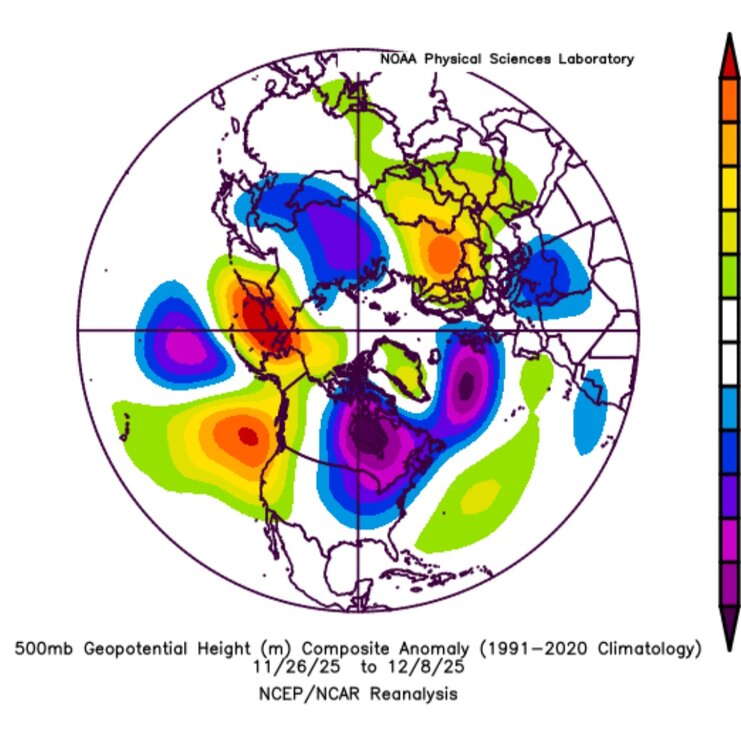
NOV 26 colder started in phase 6 headed into phase 7 & then into phase 8 through DEC 6. Here is the pattern NOV26-DEC 8 It appears the MJO did indeed influence the pattern....pretty strongly.
-
Totals for VT ...Vermont... ...Addison County... Starksboro 4.4 ENE 2.7 in 0900 AM 12/11 44.24N/72.97W Bristol 2.2 in 0645 AM 12/11 44.14N/73.09W/533 Shoreham 3.5 NNE 2.0 in 0800 AM 12/11 43.94N/73.28W/275 Vergennes 1.4 in 0430 AM 12/11 44.17N/73.25W/194 ...Bennington County... 5 NNW Londonderry 12.0 in 0710 AM 12/11 5 S Woodford State Park 7.8 in 1029 PM 12/10 Public Stamford 5.0 NNE 3.6 in 0400 PM 12/10 COCORAHS ...Caledonia County... Wheelock 1.6 S 5.4 in 0600 AM 12/11 44.56N/72.09W/1158 Sutton 5.3 in 0821 AM 12/11 44.61N/72.05W/1500 Wells River 2.1 WNW 5.0 in 0656 AM 12/11 44.23N/72.11W/1206 2 NE East Lyndon 5.0 in 0700 AM 12/11 44.54N/71.94W West Burke 5.0 in 0728 AM 12/11 44.64N/71.98W Danville 0.4 N 4.0 in 0700 AM 12/11 44.42N/72.14W/1406 St. Johnsbury 0.4 N 3.2 in 0730 AM 12/11 44.42N/72.02W ...Chittenden County... Underhill 5.1 NNE 5.1 in 0630 AM 12/11 44.60N/72.92W/908 2 NNE Underhill 4.0 in 0822 AM 12/11 44.55N/72.93W/1000 Underhill 3.6 ESE 3.5 in 0740 AM 12/11 44.50N/72.88W Williston 0.2 WSW 3.0 in 0700 AM 12/11 44.44N/73.07W/518 Nashville 1 E 2.9 in 0645 AM 12/11 44.45N/72.93W/825 Huntington 1.1 E 2.8 in 0700 AM 12/11 44.32N/72.97W/991 Huntington 6.5 S 2.8 in 0800 AM 12/11 44.23N/72.96W/1096 Hinesburg 0.9 N 2.8 in 0854 AM 12/11 44.34N/73.11W/519 Hinesburg 1.5 SW 2.2 in 0700 AM 12/11 44.32N/73.14W/435 Shelburne 0.5 ENE 1.7 in 0700 AM 12/11 44.38N/73.22W South Burlington 2.6 SSW 1.7 in 0800 AM 12/11 44.42N/73.19W South Burlington 2.4 NNE 1.5 in 0908 AM 12/11 44.49N/73.16W Burlington 3.8 NW 0.8 in 0800 AM 12/11 44.52N/73.26W/177 ...Essex County... 1 NW Maidstone State Park 8.5 in 0906 AM 12/11 44.66N/71.65W Lunenburg 2.3 NNW 5.0 in 0500 AM 12/11 44.49N/71.70W/1472 Island Pond 4.0 in 0932 AM 12/11 44.81N/71.89W/1200 ...Franklin County... Enosburg Falls 2.5 N 5.9 in 0730 AM 12/11 44.94N/72.80W Montgomery 4.1 ESE 5.0 in 0700 AM 12/11 44.88N/72.56W/1005 Swanton 0.5 NNE 3.3 in 0700 AM 12/11 44.93N/73.12W/139 ...Lamoille County... Morrisville 7.3 in 0726 AM 12/11 44.56N/72.60W Johnson 2 N 6.0 in 0730 AM 12/11 44.66N/72.68W/980 Stowe 0.2 SW 5.7 in 0730 AM 12/11 44.46N/72.69W/731 Jeffersonville 1.3 SSW 5.2 in 0700 AM 12/11 44.63N/72.84W/804 2.5 N Smugglers Notch 5.1 in 0730 AM 12/11 44.58N/72.79W/1163 Cambridge 5.0 in 0918 AM 12/11 44.65N/72.88W ...Orange County... Randolph 7.5 in 1031 PM 12/10 43.92N/72.67W Braintree 2.8 SW 4.1 in 0700 AM 12/11 43.94N/72.75W/1610 Bradford 2.2 NNW 3.8 in 0530 AM 12/11 44.02N/72.15W/1124 1.5 E Corinth Corners 3.7 in 0650 AM 12/11 44.01N/72.32W/1180 2 SE Strafford 3.2 in 0630 AM 12/11 43.83N/72.36W Williamstown 3.0 WSW 2.4 in 0700 AM 12/11 44.11N/72.60W/1565 ...Orleans County... Westfield 0.8 WNW 8.5 in 0730 AM 12/11 44.89N/72.44W/1068 1 WNW Albany 6.5 in 0736 AM 12/11 44.74N/72.40W Craftsbury Common 6.2 in 0700 AM 12/11 44.66N/72.39W Greensboro 3.9 NNE 6.0 in 0730 AM 12/11 44.63N/72.28W/2035 Morgan 6.7 SE 5.5 in 0645 AM 12/11 44.86N/71.91W/1341 2 NNE Albany Center 5.3 in 0855 AM 12/11 44.76N/72.33W 2 N Greensboro 5.2 in 0948 AM 12/11 44.61N/72.29W Derby Line 1.9 W 5.1 in 0700 AM 12/11 45.00N/72.14W/771 Greensboro 2.1 NNW 5.1 in 0700 AM 12/11 44.61N/72.31W/1495 Brownington 4.7 ESE 4.7 in 0800 AM 12/11 44.81N/72.08W/1467 ...Rutland County... West Rutland 0.9 SSE 5.5 in 0800 AM 12/11 43.58N/73.04W/545 2 NE Hortonia 5.0 in 0400 PM 12/10 43.76N/73.20W 1 N Rutland 4.6 in 0700 AM 12/11 43.63N/72.98W/620 Rutland 1.2 N 4.6 in 0700 AM 12/11 43.63N/72.98W/629 Shrewsbury 0.8 W 4.5 in 0600 AM 12/11 43.51N/72.88W Pittsford 2.2 SSE 4.5 in 0730 AM 12/11 43.68N/73.02W Wallingford 2.7 SSW 3.6 in 0700 AM 12/11 43.43N/72.99W/602 ...Washington County... 3 SSW Waterbury 8.7 in 0445 PM 12/10 44.30N/72.78W Waterbury 3.0 NW 7.1 in 0600 AM 12/11 44.36N/72.81W/458 Woodbury 3.4 NNW 6.5 in 0700 AM 12/11 44.49N/72.43W/1624 1.6 W Worcester 6.0 in 0700 AM 12/11 44.37N/72.58W/1360 East Calais 1.5 SW 5.5 in 0700 AM 12/11 44.36N/72.46W/1054 Northfield 1.5 N 3.8 in 0700 AM 12/11 44.17N/72.65W/672 East Montpelier 3.5 in 0730 AM 12/11 44.27N/72.50W Montpelier 1.7 NE 3.0 in 0800 AM 12/11 44.28N/72.55W Warren 2.8 E 2.8 in 0700 AM 12/11 44.11N/72.80W ...Windsor County... Andover 2.5 NW 7.5 in 0700 AM 12/11 43.30N/72.74W/1766 Ludlow 3.4 S 6.8 in 0700 AM 12/11 43.35N/72.70W/1727 3 S Ludlow 6.5 in 0830 PM 12/10 43.35N/72.70W Proctorsville 0.3 NNE 6.4 in 0700 AM 12/11 43.39N/72.64W/983 Chester 4.1 WNW 6.1 in 0800 AM 12/11 43.27N/72.67W Hartland 4.1 W 5.5 in 0800 AM 12/11 43.53N/72.48W/1140 Chester 3.0 WSW 5.2 in 0700 AM 12/11 43.24N/72.65W/1097 Barnard 2.7 NW 4.5 in 0700 AM 12/11 43.75N/72.66W 3 NW Barnard 4.5 in 0716 AM 12/11 43.76N/72.66W Rochester 1.7 NNE 3.6 in 0500 AM 12/11 43.90N/72.80W 0.6 E Woodstock 3.6 in 0800 AM 12/11 43.63N/72.51W/600 North Hartland 1 NNE 3.0 in 0700 AM 12/11 43.60N/72.36W/562
-
Gfs hung on the longest with 4" in the first threat here and finally caved at the end.
-

Minor snow possible sunday 12/14/25
LoboLeader1 replied to WeatherGeek2025's topic in New York City Metro
We need a negative tilted trough. -
Eastern Loudoun here. Perhaps a coating if lucky
-
Yep, there's always payback! Hopefully there won't be that much payback for all the cold we've seen for the past few weeks...