All Activity
- Past hour
-

Central PA Winter 25/26 Discussion and Obs
canderson replied to MAG5035's topic in Upstate New York/Pennsylvania
IMO no one should ever apologize for a forecast - ESPECIALLY hobbyists like us. Especially since you basically nailed this event better than mostly any pro out there. -
i'm hurting; th ebig snowblower is heavy for me and the smaller one is shit on my uneven pavers. still gotta do my sil but my son lives in an apartment upstairs but claims he is working from home so can't come out til 5....state worker for the dep....i'm like dude do you have an ankle bracelet? one of the deals they cut was if they can work from home, they gotta do so even if everything is shut down.....
-

"Don’t do it" 2026 Blizzard obs, updates and pictures.
klw replied to Ginx snewx's topic in New England
No need to wait, just watch there traffic cams. Some are snow coated but others are great. https://www.dot.ri.gov/travel/index.php -

"Don’t do it" 2026 Blizzard obs, updates and pictures.
jbenedet replied to Ginx snewx's topic in New England
This storm is remarkable in the sense that its heaviest snows are happening in the most densely populated areas. That banding that stalled over Philly last night, NYC sw CT and LI this and then Gloucester, Boston SE MA/RI CCB -
The NAM did well, it was obviously way overdone in a lot of places (especially northwest of here, where it definitely failed for many runs). But even its extreme solutions were closer to reality than the way underdone rgem and earlier euro runs.
-

2025-2026 Fall/Winter Mountain Thread
Buckethead replied to Buckethead's topic in Southeastern States
I measured 5.5" at 9. I just measured and have a little over 5" now lol. That wind is intense! Currently 6° with moderate snow and 20mph+ wind with gusts to 40. Sent from my Pixel 10 Pro using Tapatalk -

"Don’t do it" 2026 Blizzard obs, updates and pictures.
Hoth replied to Ginx snewx's topic in New England
Awesome picture. Brings back '15 vibes for me in Cambridge. -
Nassau County in one of the heavier bands for a while now, missed a lot of them during the night.
-

"Don’t do it" 2026 Blizzard obs, updates and pictures.
mcglups replied to Ginx snewx's topic in New England
band looks to be rotating more NE/SW and heading E with the peak about to cross over Newport, it has been a complete hammer for numerous hours, looking forward to venturing outside soon! -

E PA/NJ/DE Winter 2025-26 Obs/Discussion
Duca892 replied to LVblizzard's topic in Philadelphia Region
We TRACK! -
Yup. Might be my imagination, but there seems to be some kind of voodoo that gets us in the largest storms. At least it's still a lot of snow.
-

"Don’t do it" 2026 Blizzard obs, updates and pictures.
SouthCoastMA replied to Ginx snewx's topic in New England
what a cocktease here. just stalled 10 miles to my west and not budging -

"Don’t do it" 2026 Blizzard obs, updates and pictures.
Scott Koziara replied to Ginx snewx's topic in New England
Just lost power on Ruggles! -
Yep I don’t care where you are these powerhouse nor Easter’s are fascinating and must see viewing. This is the rare one that shows Mother Natures max potential for winter storms on the east coast. Sub 970 low with 4”+ per hour rates and gusts recorded on coast approaching 90 with multiple major cities reporting blizzard conditions simultaneously. This is going to be one of the benchmark east coast events
-

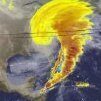
Feb 22nd/23rd "There's no way..." Obs Thread
rjvanals replied to Maestrobjwa's topic in Mid Atlantic
That band sat over my house for 45 minutes and was putting down 1.5/hr rates. -
Up there with some of the all time greats in terms of satellite images for sure.
-

"Don’t do it" 2026 Blizzard obs, updates and pictures.
ineedsnow replied to Ginx snewx's topic in New England
not far at all I'm close to Narragansett school -
"Don’t do it" 2026 Blizzard obs, updates and pictures.
TripplePhaser replied to Ginx snewx's topic in New England
I have a feeling coastal Maine and the New Hampshire Seacoast will be next to get pummeled later this afternoon! -

"Don’t do it" 2026 Blizzard obs, updates and pictures.
Layman replied to Ginx snewx's topic in New England
It's almost like you needed this though... -
22 - 24 over my dogs heads
-
i'm gonna come up short. don't care. great storm. probably 18-20 otg. stil snowing but not accumulating much. we'll see if any more death bands come through. according to RU the big bands were early morning out here.
-

"Don’t do it" 2026 Blizzard obs, updates and pictures.
tavwtby replied to Ginx snewx's topic in New England
I've got to say, I still had about 10-12" OTG before this, glacier piles on the roadside, going to be fun clearing this later, some sick drifts between the cars and the normal spots in any NE wind driven storm... seems more N-S now, my anemometer is now frozen, highest gust I had was just over 50, that was like 3 hours ago, visibility decreasing again I'm thinking about 1/2 should be done here to get cleaning up. -
Yeah - I just got in from two hours of shoveling and snowblowing...and probably have another two hours to do later in the day. How much snow do you think we have so far?
-
What model do you think performed best? It looked to me like the NAM picked up on the sharp cutoffs to the west and the 10" I have here are maybe a bit over what it's last couple of runs showed for western NJ, but definitely within the range.
-
Happy for the coast and immediate metro. This came up short in N/C Jersey. 14" in Montgomery, no drifts, tame wind. Nice storm, not one of the all-timers here.


