All Activity
- Past hour
-
i think he meant for the storm lol. Westerly got 11.6" and there was a Voluntown 4SW report of 10.8 but thats the only report i saw over 10 in CT.
-
Good! Maybe we can move towards a model compromise by mid week.
-
They did, 14.2 in Kingston, RI cocorahs. With many reports 11-12"
-
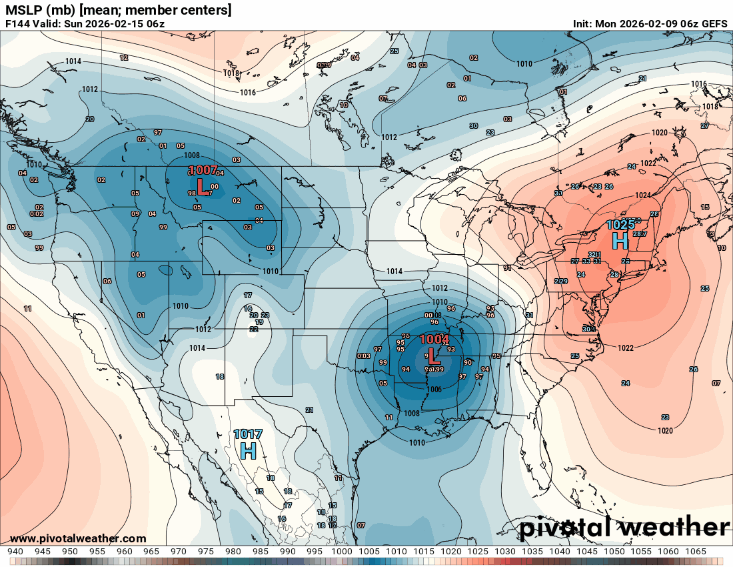
12z GEFS definitely with a colder push and much more pronounced wedge this run, it's not over yet!
.gif.c536681ec03cb44f7b3a95415e25322d.gif)
-

February 2026 OBS & Discussion
CPcantmeasuresnow replied to Stormlover74's topic in New York City Metro
For the season? No possible way that could be correct. -
 Ukie with a thump as well... I'd take the stat pad...though snow immediately washed away by a bunch of rain is my least favorite kind. I'd love for the heaviest to be snow and just some liiiiight rain afterward to keep some of the snow around
 -

Southern MD / Lower Eastern Shore weather discussion
AlexD1990 replied to PrinceFrederickWx's topic in Mid Atlantic
Starting to feel like we may have seen the last of significant snow threats down here. time will tell... -
That's too funny, I grew up up the street from the kicken chicken, and my family knows the owner quite well. Lewes is a truly beautiful town with a rich history that I never tire of telling visitors about(giant history nerd) Sounds like you also found what we used to call the "secret beach" by Roosevelt Inlet. One of my favorite places to go and relax, wade in the Bay when there aren't too many jellyfish. Right now it's all frozen over, which is truly surreal. Last time i saw that was 2015, and before that my mom remembers it happening in the late 70s. It sucks that we don't get as much snow as some, but i have truly loved my life living here, just wish i could afford an actual home down here. Being a resort area and the massive amount of transplants from the big cities, its nearly impossible. I truly hope the county government down here gets a thought in their collective heads to stop the reckless development, but I'm not holding my breath,.
-
The Sierra's are certainly going to be making up their snow deficit
-
And that's a big part of what made it so good! I didn't understand a word except mannana but I felt all the themes, and I felt the very soul of Puerto Rico throughout the entire performance. The music was better than I expected (not my usual cup of tea but I can objectively appreciate quality of music if when I hear it!)...and the entire production was fantastic!
-
Regardless, prospects of heavy qpf is potentially the most important news coming out of this as regards helping with the drought. The SE needs the rain!
-

Feb 10-11 Mid Week Minor Event - Ride the hot hand?
HoarfrostHubb replied to HoarfrostHubb's topic in New England
Very low ceiling on it... just a distraction -
12z GEFS definitely building the high in stronger this run, might still look decent for WNC.
-
February 9 1899: The mercury plummets to -59 at Leech Lake Dam. For Monday, February 9, 2026 1870 - President Ulysses S. Grant signed a law "to provide for taking meteorological observations at the military stations in the interior of the continent." A petition submitted by Increase A Lapham to Congressman Halbert E Paine in December 1869 began this process. 1933 - The temperature at Moran, WY, located next to Teton National Park, plunged to 63 degrees below zero to establish a state record. The temperature at the Riverside Ranger Station in Montana dipped to 66 below zero to establish a record for the state, and a record for the nation which stood until 1954. (David Ludlum) 1934 - The mercury dipped to 51 degrees below zero at Vanderbilt to establish a record for the state of Michigan. The temperature at Stillwater plunged to 52 degrees below zero to establish a record for the state of New York. (David Ludlum) 1987 - A storm off the Atlantic coast produced high winds and heavy snow in the northeastern U.S., with blizzard conditions in eastern Massachusetts. Wind gusted to 80 mph and 23.4 inches of snow produced drifts eight feet high at Cape Cod MA. It was the worst blizzard in thirty years for the Cape Cod area. Winds in some of the mountains and ridges of the Appalachian Region gusted to 100 mph. (The National Weather Summary) (Storm Data) 1988 - Arctic cold invaded the north central U.S. Alliance NE plunged from 44 degrees to 12 above in just two hours, and Mobridge SD reported a wind chill of 64 degrees below zero. Winds along the eastern slopes of the Rockies gusted to 90 mph at Cheyenne WY, and reached 96 mph at Boulder CO. (The National Weather Summary) (Storm Data) 1989 - A winter storm continued to bring rain and snow to southern California. Snowfall totals ranged up to 18 inches at Olancha, with three inches at Palmdale. (The National Weather Summary) (Storm Data) 1990 - Thunderstorms developing ahead of a cold front erupted over eastern Texas late in the morning, and produced severe weather as they swept across the southeastern states. Early evening thunderstorms spawned a tornado which injured one person at Nat TX, and produced tennis balls size hail which caused more than half a million dollars damage around Shreveport LA. (The National Weather Summary) (Storm Data) 1994 - A devastating ice storm struck Mississippi, Louisiana, and extreme northwest Alabama. Freezing rain began falling over northern Mississippi during the early morning hours and continued until midday on the 10th. Ice accumulated 3 to 6 inches thick on exposed objects in the affected area. Due to the weight of the ice, power lines, trees, and tree limbs were down. Nearly one million people were without power after the storm, some for a month.
-
February 2026 OBS & Discussion
CPcantmeasuresnow replied to Stormlover74's topic in New York City Metro
The way some people classify March is almost comical. In many parts of the forum average temperatures in early March are still below freezing. To call it a spring month, even though I know it's part of Met Spring, is misleading unless you're referencing late March in the southern portions of the forum. Of course it can snow in April in any part of the forum. -
hot weather is absolutely more tolerable than cold. how can people live where most of the winter is like the past two weeks
-
lol
-
not many? it's a small sample, i'll admit. but we'r e not getting any moisture at all lately.
-
Severe or ice, who knows?
-
who had 13 in SECT? must have been tossed
-
The forcing shifting east of the Dateline in late January allowing the STJ to become more dominant for a week put most of the major stations close to the coast near or over 25” which is a great outcome for this 2020s climate. The long range guidance sustains the present forcing west of the Dateline into mid-March. So it looks like more of a split flow or Northern Stream dominant storm track pattern which could allow for a smaller or maybe even moderate snowfall event before the end of the season. But probably not a STJ dominant pattern that can produce another widespread 10”+ benchmark NESIS event near the coast. Hoping the spots that are still under 25” can get just enough so they can make it to 25”+. CT IGOR I SIKORSKY MEMORIAL AIRPORT WBAN 34.4 NY UPTON COOP - NWSFO NEW YORK COOP 29.8 NY ISLIP-LI MACARTHUR AP WBAN 28.6 NJ NEWARK LIBERTY INTL AP WBAN 25.3 NEW BRUNSWICK 3 SE COOP 24.5
-
I may have spoken a tad soon, lol Still got some time...
-

February 2026 Medium/ Long Range Discussion: 150K Salary Needed to Post
Ji replied to Weather Will's topic in Mid Atlantic
-
Every day since it snowed.
-
 CMC is a nice paste bomb for the interior. I'm rooting for that.
.thumb.png.4150b06c63a21f61052e47a612bf1818.png)


