All Activity
- Past hour
-
I'll take a 3/17 here all day long, that was a great storm here anyway.
-

Feb 22nd/23rd "There's no way..." Storm Thread
GreyHat replied to Maestrobjwa's topic in Mid Atlantic
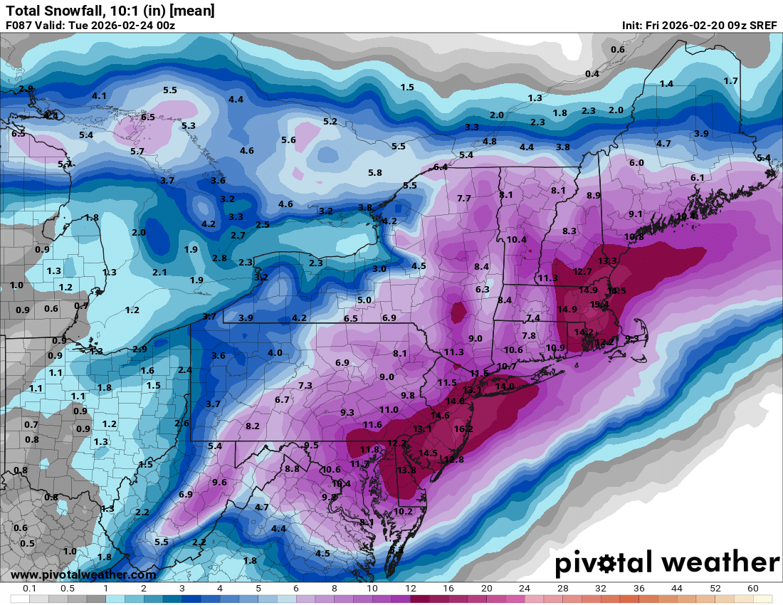
Snow fall maps are waste, with temps, rain, wet ground. You need to keep expectations down. @mitchnick nws has the right idea 1-3" if your lucky on grass areas. Higher elevation may see more. The rain will be a welcoming sight for water tables. I like snow like everyone else and wouldn't mind a government delay opening. -
What are those two sref models
-
Maybe you'll get 32"...
-

“Cory’s in NYC! Let’s HECS!” Feb. 22-24 Disco
The 4 Seasons replied to TheSnowman's topic in New England
It's right up the top of the list with the AARP, WRF and Icon -
Looks just like the 06z GEFS
-

February 2026 OBS & Discussion
Freezing Drizzle replied to Stormlover74's topic in New York City Metro
-
still about 36-48 hours to onset, don't know if this can come any further NW or N, but it can still trend back SE, let's hope we get consistent runs from here on to go time.
-
Even if we milk a few tenths out of this CAD, it’ll still be an impressive month for ORD. https://www.weather.gov/lot/chicago_feb_snow_rankings?utm_source=chatgpt.com .
-

“Cory’s in NYC! Let’s HECS!” Feb. 22-24 Disco
ineedsnow replied to TheSnowman's topic in New England
usually sucks -

Feb 22nd/23rd "There's no way..." Storm Thread
Interstate replied to Maestrobjwa's topic in Mid Atlantic
We are bring this one home!!! -
No
-
Lightning and thunder in dc!
-

“Cory’s in NYC! Let’s HECS!” Feb. 22-24 Disco
Snowcrazed71 replied to TheSnowman's topic in New England
Sorry to ask, but it's this model a good one to follow? -
This might be craziest sref run in a decade

-

“Cory’s in NYC! Let’s HECS!” Feb. 22-24 Disco
40/70 Benchmark replied to TheSnowman's topic in New England
It's like Dec 1992 for you. -
“Cory’s in NYC! Let’s HECS!” Feb. 22-24 Disco
The 4 Seasons replied to TheSnowman's topic in New England
so when do we start talking about the mix line? I can already hear folks bringing up Mar 2017 and Dec 2020 (but that aint happening considering the path) -
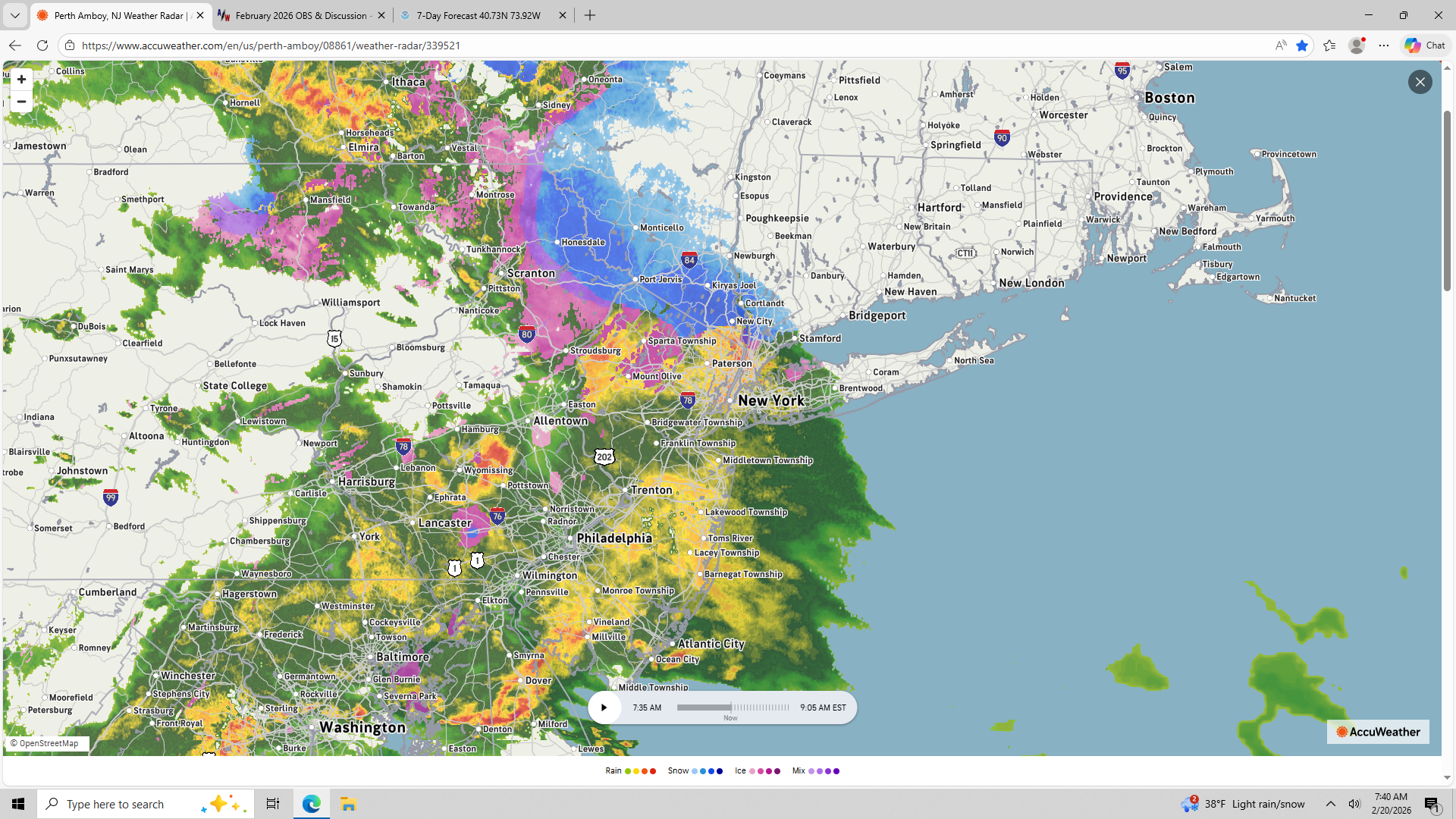
Raining at work in yonkers, once across the bridge it was a mix. Sleeting here in Nanuet.
-
Tracking a line of thunderstorms and a blizzard at the same time is wild. But here I am. There's been some heavy rain this morning. I've got a few spots left of glacier, lots of mud, and standing water. Give me 2' this weekend and the drought will be hurting.
-
“Cory’s in NYC! Let’s HECS!” Feb. 22-24 Disco
40/70 Benchmark replied to TheSnowman's topic in New England
Well, that's what I mean....we may depend on it for the western fringes... -

“Cory’s in NYC! Let’s HECS!” Feb. 22-24 Disco
RUNNAWAYICEBERG replied to TheSnowman's topic in New England
Whoosh… -

“Cory’s in NYC! Let’s HECS!” Feb. 22-24 Disco
CoastalWx replied to TheSnowman's topic in New England
Ray needs counseling from Jan 2022 -

Feb 22nd/23rd "There's no way..." Storm Thread
SomeguyfromTakomaPark replied to Maestrobjwa's topic in Mid Atlantic
I wouldn’t take them literally but I think that’s a very large shift! Hopefully indicative of things to come at 12z. -

Central PA Winter 25/26 Discussion and Obs
anotherman replied to MAG5035's topic in Upstate New York/Pennsylvania
I saw that and sluffed them off because they are the SREF. But that is a huge change. -
Dumping rain in silver spring now