All Activity
- Past hour
-
Dropped to -2° at my house in Wolf Laurel around 8:30 last night...woke up in the 20's. Currently 29° at my house at 4360, but 7° on the Cane River in the valley below my house at 2900'. The river partially froze. Sent from my Pixel 10 Pro using Tapatalk
-
If it's 4.4 we're going to have a good winter...Decembers with 4 or more tend to do well. (LOL I'm half kidding-90% of the area saw 4 or more inches so silly that they came in with 2+
-

December 2025 regional war/obs/disco thread
Ginx snewx replied to Torch Tiger's topic in New England
Something happening here with 2m temps. SWFEs?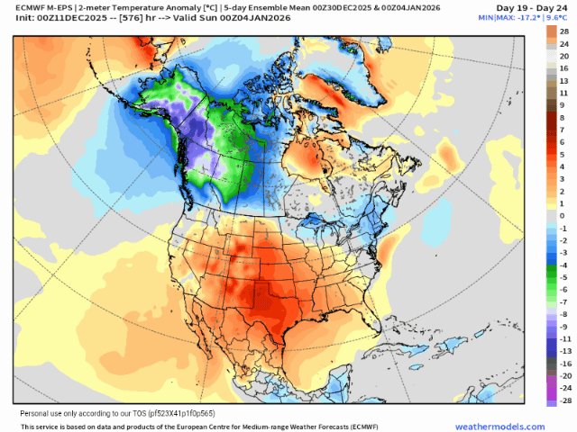
-
Mcps closing some upcounty schools (like damascus hs and baker ms) while keeping others just on the 2 hour delay. That is a first… i think. .
-
5.8 degrees for the low, new record for the date (1989 10 degrees). Least the winds are down into the 5-15 mph range this morning.
-

December 14th - Snow showers or Plowable snow?
40/70 Benchmark replied to Sey-Mour Snow's topic in New England
https://easternmassweather.blogspot.com/2025/12/verification-for-festive-sunday-snowfall.html B+ -
Definitely felt colder last night at 20 degrees with the wind whipping than this morning at 12 and fairly calm.
-
Winter 2025-2026 Offers Return to Normalcy
40/70 Benchmark replied to 40/70 Benchmark's topic in New England
Verification for Festive Sunday Snowfall Strong Forecast But Slightly too Conservative The season's first significant snowfall for the southeast coast of New England was identified at a very extended lead time using a combination of seasonal analogs, long range ensemble guidance and pattern recognition. In fact, forecast for the storm itself actually ended up being slightly too conservative. The 1-3" forecast for the central portion of the region worked out well, however, there were two primary problem areas with the overall forecast. The most obvious issue is that the 2-4" portion of the forecast over the southeastern quarter of the area actually verified in the 3-6" range, given amounts up to 5" over southwestern, Connecticut (Norwalk) and 6" on the outer half of cape cod (6" from Hyannis to Chatham). There is also a strong argument to be made that the western portion of the 1-3" area should have been extended slightly further to the north, as evidenced by the 3" total reported in Great Barington, MA in the southwestern corner of the state. This is a shortcoming that likely would have been alleviated had a follow up map been issued on Saturday, when it had become clear that the storm would track slightly further to the north. Final Grade: B+ -

Winter 2025-26 Medium/Long Range Discussion
A-L-E-K replied to michsnowfreak's topic in Lakes/Ohio Valley
p brutal looking extended -
Enjoy the 3 days of snow cover we have
-
Looks like winter ends
-

December 14th - Snow showers or Plowable snow?
Hazey replied to Sey-Mour Snow's topic in New England
6” final here. Looks beautiful outside. Congrats to everyone who got snow out of this. Stayed the course and reaped the rewards. -
Yeah not a good pattern at all.
-

Pittsburgh/Western PA WINTER ‘25/‘26
jwilson replied to Burghblizz's topic in Upstate New York/Pennsylvania
Long-term, the warmth has muted somewhat, but the pattern remains pretty hostile. Still seeing shots of cold with brief hints of 50s preceding them. More "seasonal" temps, overall. Seems the -PNA is locking in for the foreseeable. The other indices might head in the right direction, but until we fix the pacific side, the true snow events and sustained winter might be harder to find. For a muted Nina that seems about right. We don't want to see what the long-range EPS and GEPS show, however. Full latitude ridging and the cold air is scoured out of nearby Canada, but the long-range warm looks have been difficult to trust. Seems the models want to revert to a more typical Nina base state (of moderate variety or stronger). Maybe come January we can re-establish a more favorable pattern. -
No, I’ll pass lol. 26.6 is coldest I saw for here (at 7:40 AM)
-
Bottomed out at an impressive 14.5. Dewpoint got all the way down to -3! Currently 15.3
-

December 2025 Short/Medium Range Forecast Thread
Carvers Gap replied to John1122's topic in Tennessee Valley
The 0z Euro is much different w/ the Dec19-20 cold front potential. I think it likely wrong. The 6z AIFS has the cold front. It would not surprise me to see snow flurries or snow showers behind that front. If you watch the 6z GFS at 500, it makes sense. It pops a ridge in the East. It gets knocked down. The next ridge(chinook) pops further west. It gets knocked down. Each time the ridge goes up, it gets knocked down, and retrogrades westward. By the end of the run, it is a EPO ridge. Jax mentioned the atmospheric river. It may well be we are still in a base-cold pattern w/ the AR overwhelming the MJO signal which wouldn't be unprecedented (reference earlier discussion). As it retracts, that trough would slide right back into the East. I need to actually look at modeling in the Pac to see if that is happening. Interesingly, western Montana has had severe flooding when they should have had snow. Troy and Libby have lost several bridges in western Montana. -

E PA/NJ/DE Winter 2025-26 Obs/Discussion
Violentweatherfan replied to LVblizzard's topic in Philadelphia Region
So it seems late December will be our next shot at snow. The MJO looks to be in the circle of death. I read in the NYC forum that there might be some blocking during that time frame. What else is needed for a classic winter storm, there is one piece missing…I believe it’s the PNA needs to be either positive or negative. Can someone help me out The MJO should be in phase eight, need a negative NAO for blocking and what else -

December 2025 regional war/obs/disco thread
Kitz Craver replied to Torch Tiger's topic in New England
Back to diffuse clippers traversing way north of SNE after the cutter -
Just saw the Brown University suspect was released..
-
14f low
-
He makes stuff up on his own
-
Down to 10.8. .
-
13.5! Let’s do this again in Jan, preferably after 10 inches of snow.
-
Did twitter tell you that?


