All Activity
- Past hour
-
what a lovely day comfortable temps nice breeze i wish it was like this all summer me and my hoodie.
-
62 now. Forecast high is 69…hope we make it.
-
Probably the last few minutes of sun here. Can taste the marine layer approaching .
-
No man I meant that they weren't stressed BEFORE he got here. Which means he and his staff are gonna rebuild that foundation
-
Yup…sweet clearing behind this band of clouds coming in from the east. Even in the middle of it there’s breaks.
-
April 17 Dep through the warmest vs the averages EWR: +6.5 NYC: +6.0 LGA: +5.3 JFK: +5.2
-
That’s what my other Nashville friends said. .
-
Congrats Berks and WCT in SNE based on satellite.
-
Early morning sun then the stratus came flying in from the east. 57.
-
62. Socked in still.
-
What a difference a day makes. At this time yesterday it was already 70/62 with a ripping southeast wind. Today at the same time it's 39 with a wind chill of 27.
-
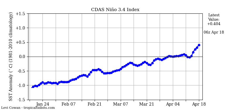
The cold biased CDAS 3.4 is still rising rapidly as it is now up to +0.404, a rise of ~0.1/day the last 4. Equivalent RONI is ~-0.1 although bc RONI is probably ~+0.1:
-
Up to about 6.8" for the month and over 11" across Mar-Apr to date. We had just 0.01" in Feb so quite an upgrade. Most of WI-IL border region is well over 10" month to date.
-
(002).thumb.png.6e3d9d46bca5fe41aab7a74871dd8af8.png)
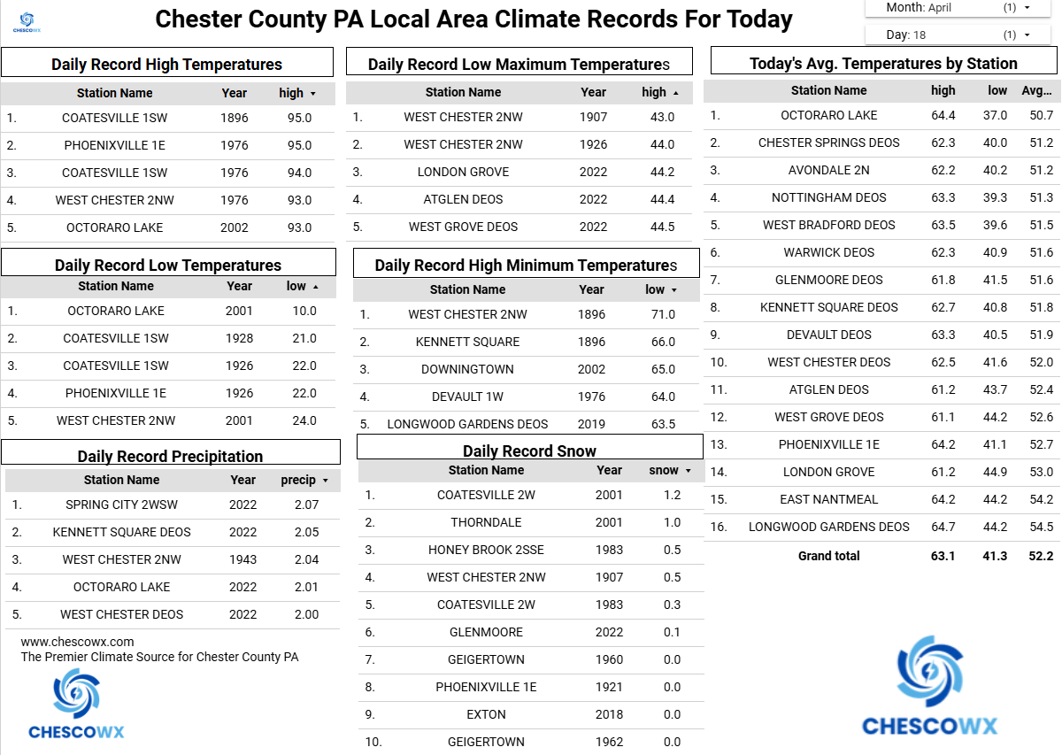
Central PA Spring 2026 Discussion/Obs Thread
ChescoWx replied to Voyager's topic in Upstate New York/Pennsylvania
Today will be our last above normal day though Wednesday. Today’s temperature will approach 70 degrees especially the further west you go. Tomorrow temperatures will struggle to escape the lower 50's. We should see some showers along the cold front during the morning tomorrow with between 0.10" to 0.40" of rain possible. By Monday temperatures in the higher spots will likely stay in the 40's with a freeze likely Monday night into Tuesday morning. We start to moderate with temperatures back to several degrees above normal in the low 70's by Friday.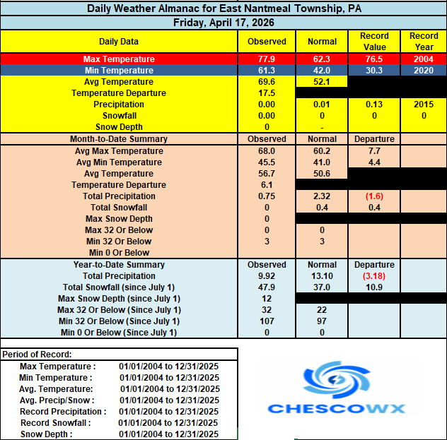

-
E PA/NJ/DE Spring 2026 Obs/Discussion
ChescoWx replied to PhiEaglesfan712's topic in Philadelphia Region
Today will be our last above normal day though Wednesday. Today’s temperature will approach 70 degrees especially the further west you go. Tomorrow temperatures will struggle to escape the lower 50's. We should see some showers along the cold front during the morning tomorrow with between 0.10" to 0.40" of rain possible. By Monday temperatures in the higher spots will likely stay in the 40's with a freeze likely Monday night into Tuesday morning. We start to moderate with temperatures back to several degrees above normal in the low 70's by Friday.
-
Yeah…sorta what I thought. I’ve seen this on social media quite a bit and how they try to “forecast” the migration (millions of birds per night) using what appears to be the ducting rings of clutter. It all seemed like voodoo to me. It’s like they’re using some kind of forecast prog algorithms to predict nightly inversions and say those areas have the highest migration rates. The real bird sigs are more random. It seems like something was lost in translation between the met/radar experts and the bird scientists/programmers.
-
Sunny in Portland. 53F
-
April 18 2004: A strong cold front whips up winds of up to 55 miles an hour over southern Minnesota. The wind causes black clouds of soil to lift into the air, creating soil erosion and reduced visibility. Some old-timers remarked that it reminded them of the dust storms from the 1930's Dust Bowl era. 2002: Baseball-sized hail falls in Eagan, creating small craters in the soft ground and broken windows in apartments. 1977: A tornado touches down at the mouth of the Minnesota River. For Saturday, April 18, 2026 1880 - More than two dozen tornadoes were reported from Kansas and Arkansas to Wisconsin and Michigan. More than 100 persons were killed, including 65 persons at Marshfield MO. (David Ludlum) 1906 - A severe earthquake shook San Francisco, and unusual easterly winds spread fires destroying the city. (David Ludlum) 1944 - California experienced its worst hailstorm of record. Damage mounted to two million dollars as two consecutive storms devastated the Sacramento Valley destroying the fruit crop. (The Weather Channel) 1957 - A dust devil near Dracut MA lifted a small child three feet into the air, and rolled two other children on the ground. Fortunately none of the three were hurt. The dust devil was accompanied by a loud whistling sound as it moved westward. (The Weather Channel) 1970 - Rapid City, SD, received a record 22 inches of snow in 24 hours. (17th-18th) (The Weather Channel) 1987 - Thirty-one cities in the central U.S. reported record high temperatures for the date, including International Falls MN with a reading of 88 degrees, and Bismarck ND with a high of 92 degrees. A sharp cold front produced high winds in the western U.S. Winds in Utah gusted to 99 mph at the Park City Angle Station, and capsized a boat on Utah Lake drowning four persons. (The National Weather Summary) (Storm Data) 1988 - Afternoon and evening thunderstorms produced large hail and damaging winds in the southeastern U.S. A strong (F-2) tornado severely damaged seventeen mobile homes near Bainbridge GA injuring three persons. (The National Weather Summary) (Storm Data) 1989 - Thunderstorms produced large hail and damaging winds in Texas, Oklahoma and Arkansas. A thunderstorm in Pecos County of southwest Texas produced wind gusts to 90 mph at Imperial. (Storm Data) (The National Weather Summary) 1990 - Heavy snow blanketed the west central valleys and southwest mountains of Colorado with up to 18 inches of snow. Nine cities from the Mid Mississippi Valley to the Middle Atlantic Coast Region reported record low temperatures for the date, including Fort Wayne IND with a reading of 23 degrees. (The National Weather Summary) (Storm Data)
- Today
-

2026-2027 El Nino
snowman19 replied to Stormchaserchuck1's topic in Weather Forecasting and Discussion
@Bluewave This El Niño is projected to become extremely well coupled (ocean-atmosphere) with a “Bjerknes feedback” response by June. Mirroring the super events of 1982, 1997 and 2015. A very strong +IOD is also forecasted to develop this summer, which will further constructively interfere with the Nino. I have a feeling we are going to remember this one for a very long time: “When it comes to El Niño, atmospheric changes matter just as much as changes in sea temperatures. That's because it's a coupled ocean-atmosphere phenomenon. Looking at velocity potential, which marks areas of rising air (green) and sinking air (brown) in response to warming and cooling tropical seas, a strong atmospheric El Niño response is forecast this year starting in June. That response is predicted to be quite similar to past big El Niño events, such as in 2015, 1997, and 1982. However, the atmospheric response in 2026 is forecast to be much different — and much stronger — than in 2023. These changes in the Walker Circulation arise from warm seas shifting from west to east across the tropical Pacific, which causes more thunderstorms in the east and fewer toward the west. This ultimately has flow-on effects on weather patterns across the planet due to changes in jet streams, as those thunderstorms release heat into the atmosphere.” -
Sunny with a light breeze and 70. This morning is great! The downside to this April is how dry it is, especially when I am trying to establish a new lawn. Sprinklers getting huge workouts
-
Usually favors the Southeast for heavier precipitation but we'll see how it evolves. Either way no more 80's and 90's for a while.
-
Picked up .28" rainfall yesterday afternoon in three separate rounds of quick moving but intense downpours. Total over the last 4 days .58". Got lucky in my neighborhood.
-
Picked up 0.50" of rain yesterday around here with the initial stm dropping hail up to 1.5" in size, the core of which just missed me to the S & E. Just pea hail imby. Cold weekend on tap. Lows in the 10's/20's this morning. EDIT: Just now saw my first robin
-
Do the Hallmark cards for this include To Do lists on the inside?
-
deep blue sky, warm sun, cool and breezy. let’s see if that marine layer comes in off the ocean but right now it’s perfect outside 65/51 gusts to 20