All Activity
- Past hour
-
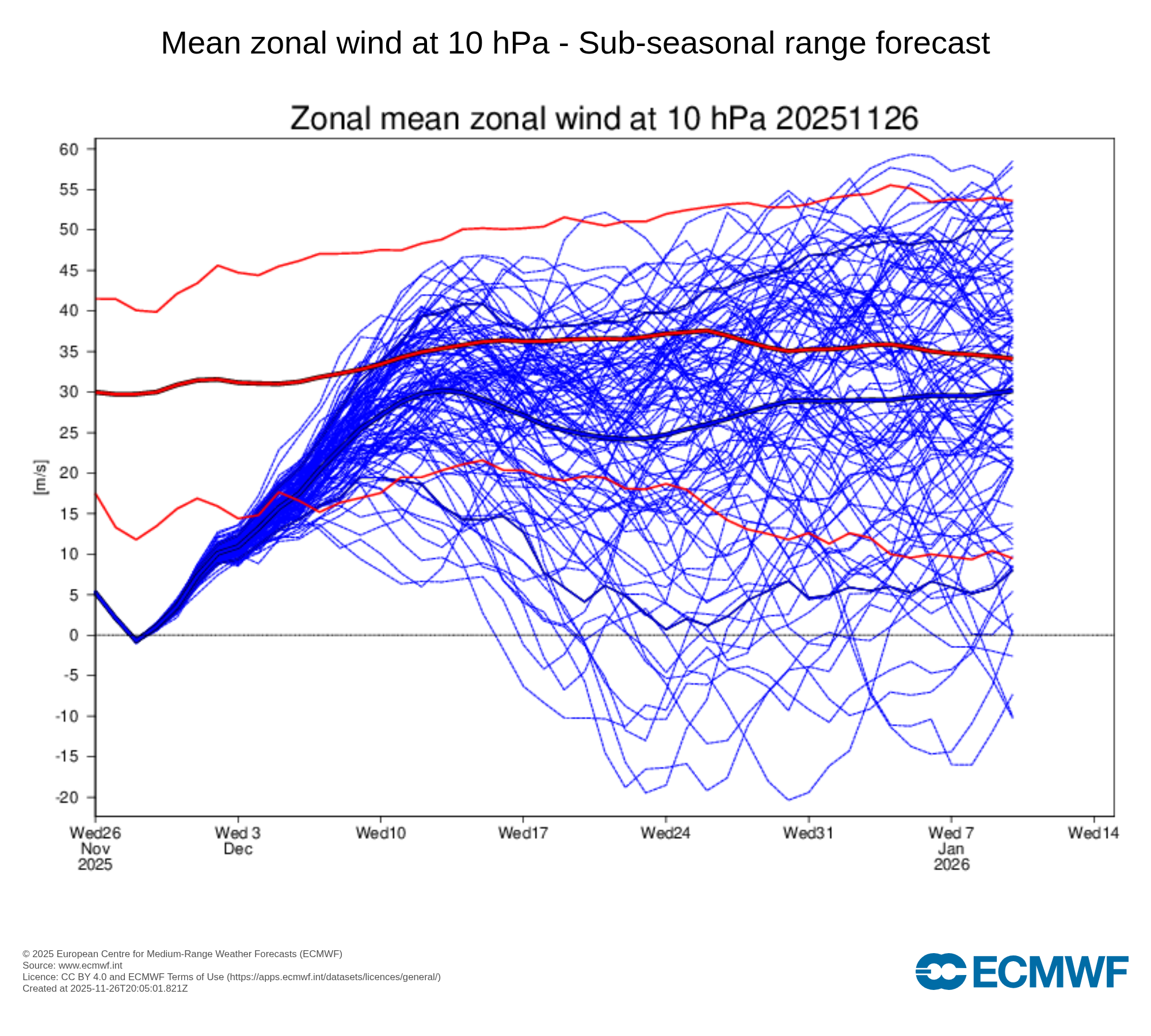
First mention of dec 2 system from LWX Forecast confidence decreases markedly by Tuesday. On the synoptic scale a shortwave embedded within a much broader longwave trough encompassing much of the CONUS is expected to lift northeastward out of the base of the longwave trough and interact with what should be a sharp baroclinic zone in place along the East Coast. Various sources of both deterministic and ensemble guidance show a large amount of spread with respect to what will ensue with this system. Some solutions show large precipitation totals, while others show little precipitation at all. Some show snow, some show a wintry mix, and others show plain rain. As is typical, temperatures look to be colder the further north and west one goes, so those locations have a greater chance to experience wintry precipitation if it were to occur. It`s too early to get into details at this point, but this system will be one to monitor over the next several days, as it has at least a chance to bring portions of the area their first wintry precipitation event of the year.
-
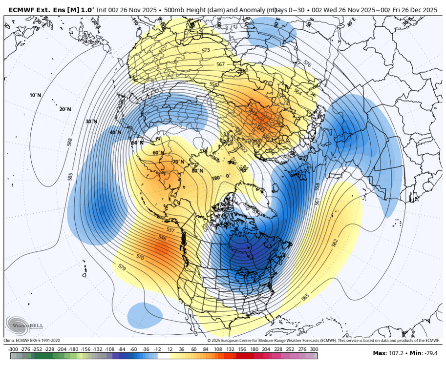
The weeklies keep slowly amplifying the Scandi ridging toward the North Pole over the course of December. They pop a western ridge too in week 3. That would be pretty sweet.
-

December 2025 regional war/obs/disco thread
Baroclinic Zone replied to Torch Tiger's topic in New England
Bus gonna be firing up soon.
-

-
Weeklies are cold right through early January .
-

2025-2026 ENSO
TheClimateChanger replied to 40/70 Benchmark's topic in Weather Forecasting and Discussion
-
Its below average through the 1st week of January even here also.
-
Where's the snow Joe?! Lol
-
lotta spread though
-
Nice line of storms coming through north central MD now
-

Central PA Fall Discussions and Obs
Superstorm replied to ChescoWx's topic in Upstate New York/Pennsylvania
Nice quick line of of showers/storms moving through…. . -

December 2025 regional war/obs/disco thread
Snowcrazed71 replied to Torch Tiger's topic in New England
I know there's some people on here that may push the envelope, but I'm not one of those people who ever need to jump out in the crowd and say here I am. I just like messing with people. Now, back to our regular programming -

December 2025 regional war/obs/disco thread
mahk_webstah replied to Torch Tiger's topic in New England
It’s here it’s queer and it’s fabulous. Get used to it. -

2025-2026 ENSO
michsnowfreak replied to 40/70 Benchmark's topic in Weather Forecasting and Discussion
Weeklies below avg every week here. SE ridge definitely appears to have been overdone. -
Mean never gets to normal at all now throughout the forecast period.

-
Just got around to looking at the 11-15 day. That is a nice look. Even though the southeast Ridge tries bubbling up I like that orientation to at least have a good baroclinic zone. I definitely would take my chances.
-

Nov 28-30th Post Turkey Day Wintry Potential
CheeselandSkies replied to Chicago Storm's topic in Lakes/Ohio Valley
Mainly I'm annoyed that because of the way the trough has evolved vs. the GFS and Euro from 3 days ago, there's no outbreak threat anywhere, not even the Lower MS Valley/Dixie, to armchair chase while getting snowed in. Some of the runs were showing upper-50s dews with solid vertical depth getting pulled as far north as northern KS on Sunday or Monday, in the presence of classic meathook hodographs. -

2025-2026 New England Snow Recordkeeping Thread
CoastalWx replied to bristolri_wx's topic in New England
Thank you! -
December 2025 regional war/obs/disco thread
Snowcrazed71 replied to Torch Tiger's topic in New England
No.. he put a poop symbol on your post... I'm just busting chops though. Was that a dig on your part though... I've been called worse sucka. -

2025-2026 New England Snow Recordkeeping Thread
bristolri_wx replied to bristolri_wx's topic in New England
@dryslot @AstronomyEnjoyer @CoastalWx check personal messages for form links. I think I'm up to date with everyone's requests. -

December 2025 regional war/obs/disco thread
SouthCoastMA replied to Torch Tiger's topic in New England
heading straight to Ptown -

December 2025 regional war/obs/disco thread
Ginx snewx replied to Torch Tiger's topic in New England
93 94 days of Leon 2 excellent back to back belly to belly snow years
-
It’s always happy hour somewhere. Let’s kick of drinksgiving right! Sapwood slayin it! Bourbon barrel aged coconut-vanilla-chocolate imperial stout. 12%.

-

E PA/NJ/DE Autumn 2025 Obs/Discussion
Fields27 replied to PhiEaglesfan712's topic in Philadelphia Region
Feels good to be back and tracking something. Especially so early in the season. With that said the past few years have left us all scarred. Seems like every storm either cuts west or shears out and goes out to sea as a weak mess. This is trending in the way of the weak miss OTS. Hopefully we break the trend soon. Measurable snow is where im setting the bar for next week. We will have the cold. Let's just get some precip! Sent from my SM-S938U using Tapatalk -
December 2025 regional war/obs/disco thread
Ginx snewx replied to Torch Tiger's topic in New England
That's not DIT brosista


.thumb.jpeg.406ecda2eec9e267302c22b9f128fe3c.jpeg)