All Activity
- Past hour
-
Got down to 32° on the dot this morning.
-
(002).thumb.png.6e3d9d46bca5fe41aab7a74871dd8af8.png)
Central PA Spring 2026 Discussion/Obs Thread
ChescoWx replied to Voyager's topic in Upstate New York/Pennsylvania
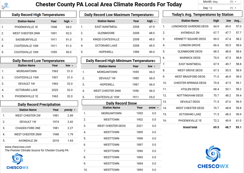
Widespread lows were in the 30’s overnight with some valley locations near or below freezing this morning. The lowest reading was the 31.5 at Warwick Township. That is tied for the 2nd coldest reading for today’s date across Chester County behind only the 31-degree low recorded at Coatesville in 1907 and Morgantown in 1963, That may well be our last freezing observation across the county until October. We continue with below normal temperatures through the rest of the work week before we warm up to well above normal temperatures starting Saturday and into next week. Rain chances increase by tomorrow night into Thursday morning.
-
E PA/NJ/DE Spring 2026 Obs/Discussion
ChescoWx replied to PhiEaglesfan712's topic in Philadelphia Region
Widespread lows were in the 30’s overnight with some valley locations near or below freezing this morning. The lowest reading was the 31.5 at Warwick Township. That is tied for the 2nd coldest reading for today’s date across Chester County behind only the 31-degree low recorded at Coatesville in 1907 and Morgantown in 1963, That may well be our last freezing observation across the county until October. We continue with below normal temperatures through the rest of the work week before we warm up to well above normal temperatures starting Saturday and into next week. Rain chances increase by tomorrow night into Thursday morning.
-
I drove through the East Quabbin hill towns yesterday. Wilderness with scattered houses. It’s so rural. Good sandwiches at Petersham Country Store though.
-
I love these chilly nippy May days
-
Weekend looks great. Heat building early next week - 80s-90 Tuesday and Wednesday looks possible
-
.87" total rain yesterday. Wonderful!! Low of 34.9 with clouds and fog.
-

Central PA Spring 2026 Discussion/Obs Thread
mahantango#1 replied to Voyager's topic in Upstate New York/Pennsylvania
It gets any colder you'll be posting snow maps. -

Central PA Spring 2026 Discussion/Obs Thread
Blizzard of 93 replied to Voyager's topic in Upstate New York/Pennsylvania
37 low in Marysville -

Central PA Spring 2026 Discussion/Obs Thread
Jns2183 replied to Voyager's topic in Upstate New York/Pennsylvania
Thursday with highs in the upper 50's seems like the last chilly day until fall. Maybe we can sneak in a few backdoor fronts in June and have a couple relief days of drizzle. Sent from my SM-S731U using Tapatalk -
Central PA Spring 2026 Discussion/Obs Thread
Jns2183 replied to Voyager's topic in Upstate New York/Pennsylvania
The one day in July I was stuck in Houston because storms cancelled my flight made me amazed anything ever was built down there. I never had so many big bites. Sent from my SM-S731U using Tapatalk - Today
-
There’s nothing anyone could possibly get out of that. It means heat on in cars and houses and extreme irritability if they live there.
-
There’s about three people and some black bears that live there.
-
41.9 for the low, impressive amount of mid 30s in northern piedmont including my farm in Louisburg at 35.5! Won’t see these temps again till next fall
-

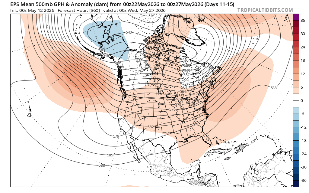
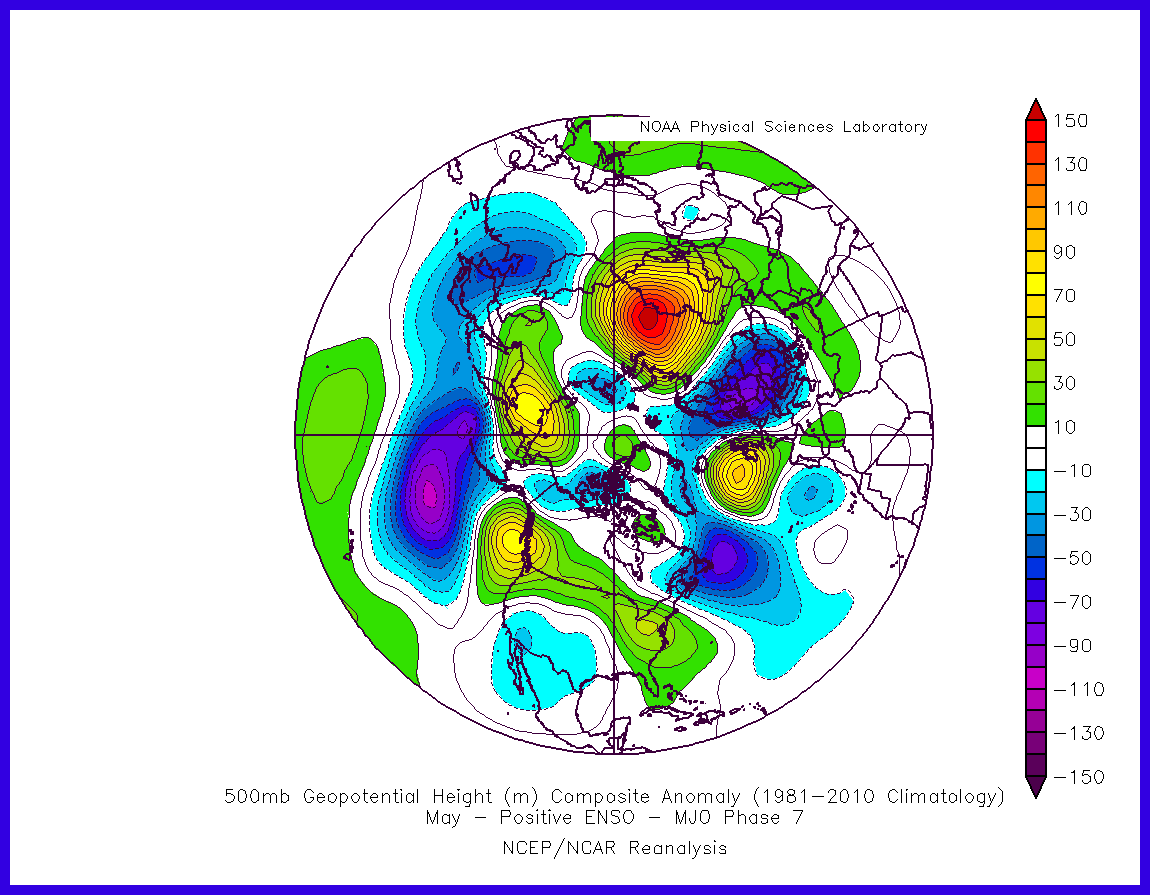
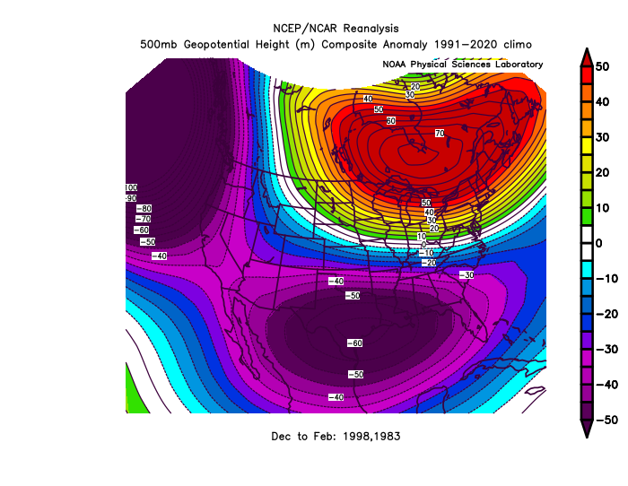
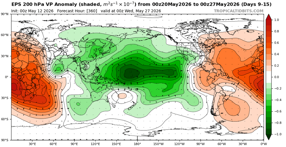
2026-2027 Strong/Super El Nino
bluewave replied to Stormchaserchuck1's topic in Weather Forecasting and Discussion
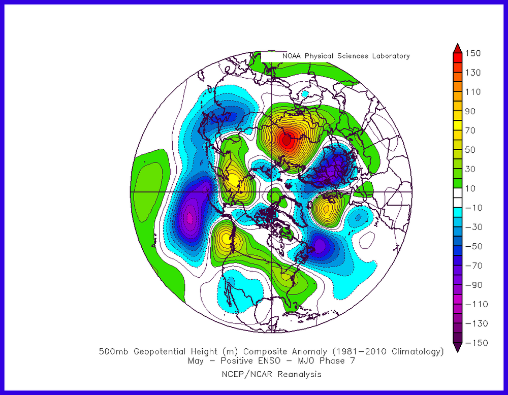
The westward lean is closer to the +ENSO MJO 7 composite with the ridge from coast to coast. But notice how the troughs are weaker in the coming forecast near the Aleutians and Baja. Similar to the weak La Niña this past winter when the ridge out West was stronger than the trough in the East. While it may be too early to draw conclusions about next winter, this would result in a weaker Aleutian Low and possibly a weaker low in the Southeast like we saw in 2023-2024 and 2015-2016 relative to 1997-1998 and 1982-1983.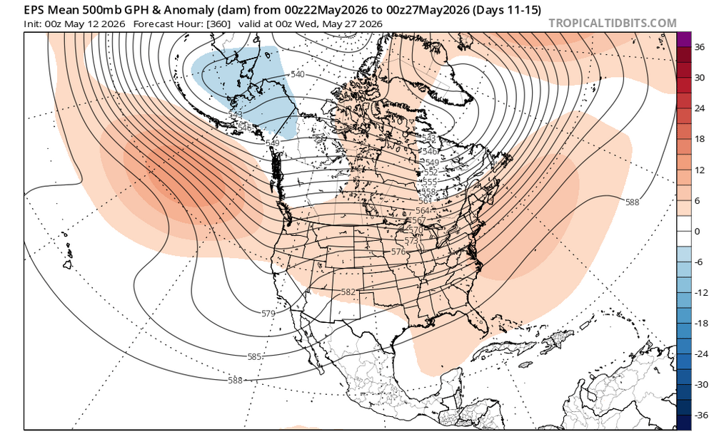
-

2026-2027 Strong/Super El Nino
Stormchaserchuck1 replied to Stormchaserchuck1's topic in Weather Forecasting and Discussion
EPS Days 11-15 looks nothing like May El Nino in the Pacific We may be running back 23-24 as far as the Pacific pattern goes -
GWDLT
-
2026-2027 Strong/Super El Nino
bluewave replied to Stormchaserchuck1's topic in Weather Forecasting and Discussion
No surprise that the El Nino is beginning to couple with a westward lean close to the +30C warm pool.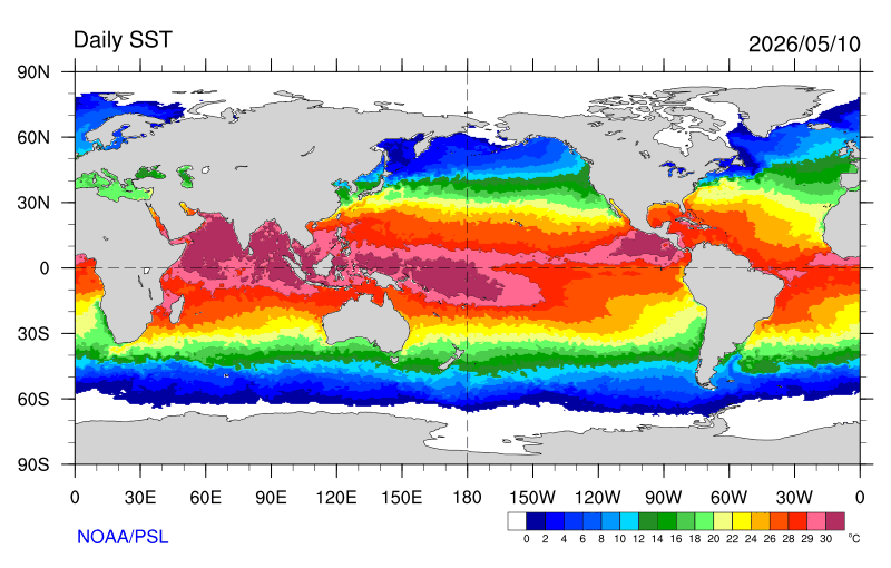
-

Central PA Spring 2026 Discussion/Obs Thread
pawatch replied to Voyager's topic in Upstate New York/Pennsylvania
29 and heavy frost. Tired of these cold mornings. Had to cover plants again last night. -
41 imby this morning. 30s at surrounding stations. 19 at canaan nwr.
-
Is there anything more exciting than frost on the car in May?
-

E PA/NJ/DE Spring 2026 Obs/Discussion
Mikeymac5306 replied to PhiEaglesfan712's topic in Philadelphia Region
Had to turn the heat back on this morning for a bit. -

Central PA Spring 2026 Discussion/Obs Thread
Mount Joy Snowman replied to Voyager's topic in Upstate New York/Pennsylvania
38 when I left the house and 36 through the rurals. Not shabby for mid May. Looks like it won’t be long before we have some sustained warmth. -
@Ginx snewx

-
That would be fine with me. It's the earliest Memorial Day possible this year. So, with almost a full week of May left after the Monday holiday, it won't really feel like the start of summer anyway.