All Activity
- Past hour
-

January 2026 regional war/obs/disco thread
wxsniss replied to Baroclinic Zone's topic in New England
Agree I've been browsing through NARR there are H5 similarities to Jan 1994 and Feb 2013... it's nice to be in a favorable setup for a change... in the what's-more-important cold vs. qpf debate for optimizing chances, we're rolling with cold for a few weeks and I think we do well -
18z ICON
-
Yeah I do not get why some models reduce their run lengths on off hours.
-

Central PA Winter 25/26 Discussion and Obs
paweather replied to MAG5035's topic in Upstate New York/Pennsylvania
Looks like 18z ICON holds serve. -
Some of the models have shown the n/s getting a little quick, which wouldn’t kill the storm quite like the Baja s/w getting buried, but it would reduce the probability of long duration precipitation and some Of the high end upside.
-
Why can’t he?
-
Arctic air has moved into the region. The temperature will fall into the middle teens in New York City tonight. Some suburban areas could see single-digit lows. Tomorrow will be another unseasonably cold day, but the temperature will reach the lower and perhaps middle 30s. Thursday will be the warmest day of the week with highs reaching or suprassing 40°. However, an even colder Arctic front will cross the region on Thursday, possibly with some snow flurries or snow showers. A frigid weekend lies ahead. Snow could arrive on Sunday. The temperature could stay below 20° in New York City on Saturday. The last time that happened was January 21, 2025 when the high was 19°. Overall, January 20th-February 3rd will likely be the coldest and perhaps snowiest two-week period this winter. The forecast WPO-/EPO-/AO-/PNA+ pattern is typically the coldest pattern in January and among the coldest during the first half of February. A persistently positive PNA will have above climatological risk of moderate or significant snowfalls. The ENSO Region 1+2 anomaly was -0.3°C and the Region 3.4 anomaly was -0.7°C for the week centered around January 14. For the past six weeks, the ENSO Region 1+2 anomaly has averaged -0.48°C and the ENSO Region 3.4 anomaly has averaged -0.68°C. La Niña conditions will likely continue into at least late winter. The SOI was +17.11 today. The preliminary Arctic Oscillation (AO) was -1.705 today. Based on sensitivity analysis applied to the latest guidance, there is an implied near 97% probability that New York City will have a cooler than normal January (1991-2020 normal). January will likely finish with a mean temperature near 30.9° (2.8° below normal). Supplemental Information: The projected mean would be 1.7° below the 1981-2010 normal monthly value.
-
I just noticed that as well. Haven’t looked at the soundings, but just looking at the surface maps it looked better
-

January 25/26 Jimbo Back Surgery Storm
franklin NCwx replied to Jimbo!'s topic in Southeastern States
Hopefully, as we head into the evening and night runs we see southern energy eject slower. It will be best for our forum if the northern jet is out ahead of the Baja low. That will flattened the flow, keep heights from rising as much in the SE. Then the Baja low will eject similar to the 12z gfs run. -
Yeah, central VA jack looks north, as well.
-
It’s definitely not over 12z, but it’s not a bad look. Probably another 4-6 for the area after 120.
-
Looks like a hold? Who knows. It's not even done at the end of the run
-
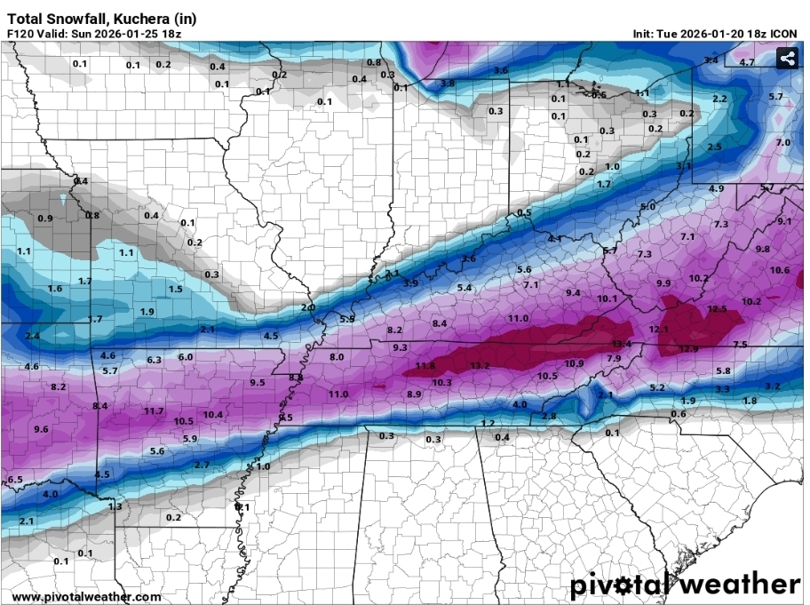
18z ICON @ 120 w/ lots of storm left to go |\ Slight iimprovement over 12z
-
Looks like the upper energy gets out in front a little bit on the ICON, so it doesn't wrap up as much.
-
It’s comes out on both, difference is the stream interaction
-

MO/KS/AR/OK 2025-2026 Winter Discussion
MUWX replied to stormdragonwx's topic in Central/Western States
No mention it a watch coming from SGF in their afternoon AFD. Kind of surprising. -
Icon is way less amped with the northern stream this run.
-
Correction..way better 18z as far as less ice
-
Icon probably just a hold
-
.thumb.png.4150b06c63a21f61052e47a612bf1818.png)
January 2026 regional war/obs/disco thread
HIPPYVALLEY replied to Baroclinic Zone's topic in New England
Maybe get DIT his once in a lifetime icer? -
Was it a full ejection at 12z?
-
With 12 days still to be inputed, TRI is one +3.3 after that warmup to start the month. Lows have been quiet cold this month. The interesting thing will be whether we can erase the +3.3, and I think that will likely occur. The chances for January to finish BN(maybe well below) are quite high, especially considering that today will almost certainly be well BN and added to the list tomorrow. Pretty amazing to see a reversal on the table after all of that warm weather. By the end of January, Dec/Jan may well average below normal for temps...even with the huge post Christmas chinook.
-
Icon with a small step south at 18z..overrunning precipitation shield was better as well
-
Icon leaves some of the southern vort behind, still should be good
-
I'm getting ready for the 18Z, anything else I need?