All Activity
- Past hour
-
Weather Next is similar to it's 06z run, it has around an inch of snow back to Nashville. Around 2 inches eastern rim/western Plateau, 3+ inches along 75 corridor to the Smokies, and 4+ in NE areas east of 81.
-
Isn’t the 0z and 12z initiated differently? .
-

The Jan 31 Potential: Stormtracker Failure or 'Tracker Trouncing
paulythegun replied to stormtracker's topic in Mid Atlantic
WOW. After ingesting MASSIVE changes in the atmosphere between 12z and 15z, SREF shows this much snow through hour 87, with more on the way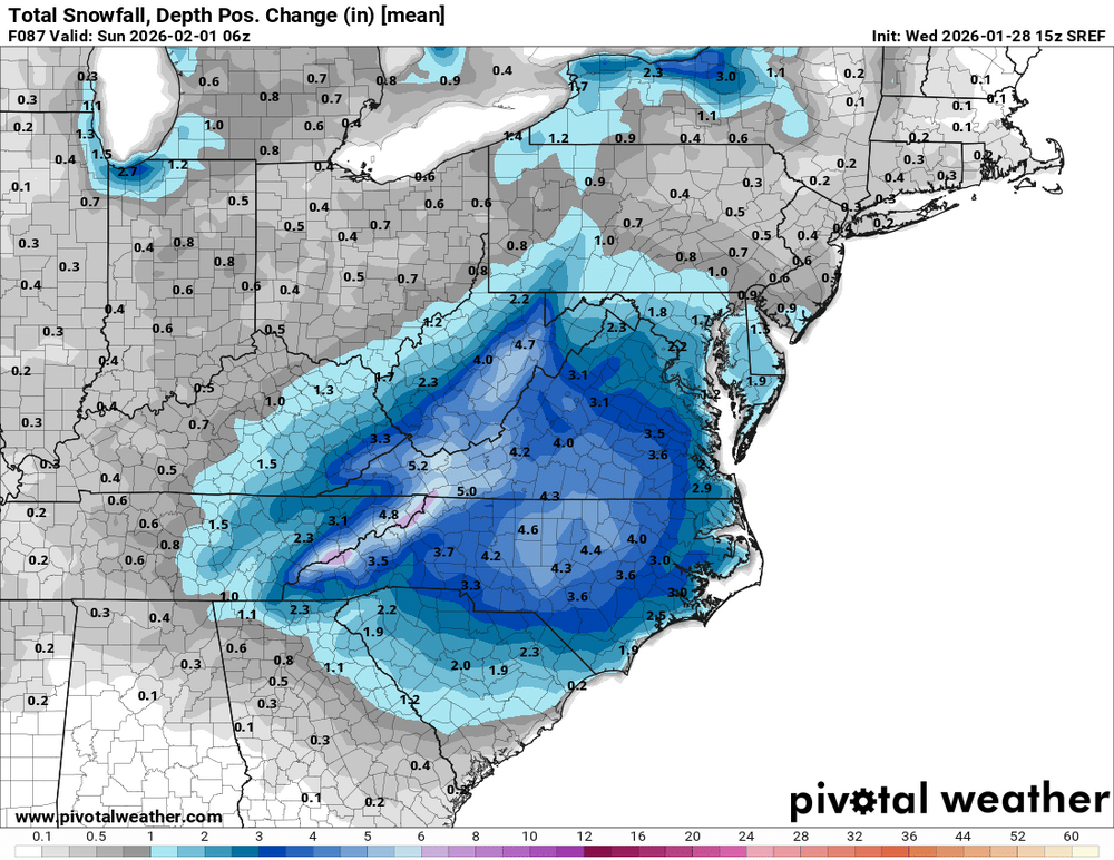
-

Possible coastal storm centered on Feb 1 2026.
Damage In Tolland replied to Typhoon Tip's topic in New England
25-50 happens often .. 100 is a little more difficult but at 4 days out with a few minor changes downstream certainly possible -

The Jan 31 Potential: Stormtracker Failure or 'Tracker Trouncing
psuhoffman replied to stormtracker's topic in Mid Atlantic
I can't look right now...but might want to take a look at the "median" or 50% map...to see if that snowfall closer to DC is the product of a few crazy outlier runs that have like 20" creating that mean of 2" in the area. We get a lot of false flags where people look at a mean on the EPS and think it's saying we should get some snow when really it's not saying that at all and the snow mean is just a product of big outlier solutions. -

Southern MD / Lower Eastern Shore weather discussion
csnavywx replied to PrinceFrederickWx's topic in Mid Atlantic
It's dwindling. We got our adjustment w/nw but it just wants to dig for oil at this point. Needed a bit more time and space to make it work. The suppression out front didn't help either. There are a multitude of reasons to never trust triple phasers and this just adds to it. Better chance of getting some consolation snow if you're out on the beaches ofc, but will take quite a feat to get it back at this point. -

The “I bring the mojo” Jan 30-Feb 1 potential winter storm
ADB83 replied to lilj4425's topic in Southeastern States
12z WeatherNext 2.0 . -

The “I bring the mojo” Jan 30-Feb 1 potential winter storm
KChuck replied to lilj4425's topic in Southeastern States
At least it's not popping out commercials every couple of minutes like the super bowl will -

Richmond Metro/Hampton Roads Area Discussion
mikeeng92 replied to RIC Airport's topic in Mid Atlantic
Not bad, I want 4" -

E PA/NJ/DE Winter 2025-26 Obs/Discussion
The Iceman replied to LVblizzard's topic in Philadelphia Region
EPS says don't throw in the towel for a pack refresher -

The “I bring the mojo” Jan 30-Feb 1 potential winter storm
Ravens94 replied to lilj4425's topic in Southeastern States
Need to make a coastal NC thread -
-
If the PNA ridge and tpv is like 150/200 miles west before it starts diving S this would have been 2016, 96 etc. absolutely brutal. Ain’t gonna lie though Sunday night and the 6z euro Ai/OP runs were some of the best in range fantasy runs in a while. Was fun for about 12 hours. We’ll have another threat in February. In fact I spoke to HM personally he’s thinking 2-3 more legit threats before end of year
-

Richmond Metro/Hampton Roads Area Discussion
overcautionisbad replied to RIC Airport's topic in Mid Atlantic
Curious what Weathernext 2.0 has now -
The ratios won't be that high for the Cape I'm pretty sure of that.
-

Possible coastal storm centered on Feb 1 2026.
Ginx snewx replied to Typhoon Tip's topic in New England
100 mile shifts are common -

The “I bring the mojo” Jan 30-Feb 1 potential winter storm
Silver Meteor replied to lilj4425's topic in Southeastern States
Hello from Greenville, N.C.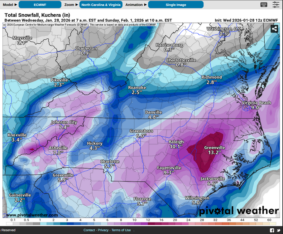
-
Sometimes there is a weenie mid-level fronto band well northwest of model progs with these rapidly maturing ULLs. This band can produce as it pivots in place on rare occasions. I think this was more commonly undermodeled in the past when model resolution was much worse. That's the only morsel of hope I can think of. This one is looking pretty bleak. A big, surprise shift NW on the next NAM run would do wonders for morale. But we have no reason to think that will happen.
-

Possible coastal storm centered on Feb 1 2026.
msg112469 replied to Typhoon Tip's topic in New England
If I recall there was a bit of waffling with the models (especially the EURO) for the last storm. Maybe there's still room for this one to come back West a bit as we get closer to the actual event. We'll know a lot more tomorrow and should be able lock in whatever's expected on Friday. -

The “I bring the mojo” Jan 30-Feb 1 potential winter storm
wxdawg10 replied to lilj4425's topic in Southeastern States
in every scenario i've seen Wake County gets hit pretty good..I think the Bullseye will be somewhere between Orange County and Greenville -

Possible coastal storm centered on Feb 1 2026.
40/70 Benchmark replied to Typhoon Tip's topic in New England
Looks like Jan 2022 in the mean...I 95 deform. -
5-7 for the south form out to Montauk. Still honestly close enough to trend towards a few inches for the city but after 0Z tonight if it still looks like this it's likely not happening.
-

Possible coastal storm centered on Feb 1 2026.
RUNNAWAYICEBERG replied to Typhoon Tip's topic in New England
We need a hundy…so please work very hard next couple days to make that happen. TIA. -
Ah nice! All that OT money.
-