All Activity
- Past hour
-
GFS at hour 27.
-
Hmmm. I don’t remember that one. Over-performer I take it?
-
The end of the ICON looked like it had the storm at the end of the month, too.
-

First Legit Storm Potential of the Season Upon Us
weatherwiz replied to 40/70 Benchmark's topic in New England
Looks like the 12z is curling the vort a bit more at 33hr compared to 6z...maybe even 0z -

E PA/NJ/DE Winter 2025-26 Obs/Discussion
Lucy Pull replied to LVblizzard's topic in Philadelphia Region
Around 3.5” here just south of Blue Mountain Ski Resort. -

Central PA Winter 25/26 Discussion and Obs
paweather replied to MAG5035's topic in Upstate New York/Pennsylvania
Just finished shoveling a good 2” here in Palmyra -
I missed his early pronouncements; was he bullish?
-

First Legit Storm Potential of the Season Upon Us
jbenedet replied to 40/70 Benchmark's topic in New England
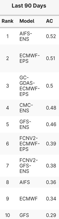
I’m with @dendrite But regardless - AIFS better than Euro/GFS, considering the list.. -
Wantage NJ: rates continue 1/2"hr. At 1035AM we're at 1.8" for the day so far. 27.3F.
-

First Legit Storm Potential of the Season Upon Us
dendrite replied to 40/70 Benchmark's topic in New England
If that's H5 AC...IIRC 0.50 is getting around d10 with the ops. -
You giving us a PBP today?
-
Wound up with an inch here. It was all Snow. I was up throughout duration; couldn't sleep. Jackpot was as GFS( Shocker) showed, Eastern Lee and Scott and Wise Counties. Official report of 2.75" Northern Scott.
-

E PA/NJ/DE Winter 2025-26 Obs/Discussion
LVLion77 replied to LVblizzard's topic in Philadelphia Region
Approaching 4” and 29 degrees here near Macungie. A pleasant surprise. . -

Another Coating of Snow Saturday - "It's all we Got"
mahk_webstah replied to Sey-Mour Snow's topic in New England
Who knows about tomorrow but 3-5 today and 1-3 tomorrow is a good weekend -

First Legit Storm Potential of the Season Upon Us
The 4 Seasons replied to 40/70 Benchmark's topic in New England
I'm not sure, its via earthlight -
@stormtracker = captain america
-
Anyone else get a Feb 2021 vibe from this or just me?
-
1.25” in Owings Mills
-
First Legit Storm Potential of the Season Upon Us
dendrite replied to 40/70 Benchmark's topic in New England
For AC's that low...what day is that? 7? 10? -
Based on radar could easily do 2” here. Quickly closing in on 1”.
-

Storm potential January 17th-18th
donsutherland1 replied to WeatherGeek2025's topic in New York City Metro
Snowing lightly in Scarsdale. -
Avengers assemble! GFS running
-
14z hrrr is pretty excited about tomorrow’s snow prospects.
-
Storm potential January 17th-18th
Lucy Pull replied to WeatherGeek2025's topic in New York City Metro
Looking at roughly 3.25-3.5” here about 15 miles NW of Bethlehem. -
First Legit Storm Potential of the Season Upon Us
The 4 Seasons replied to 40/70 Benchmark's topic in New England
Its the AI-ENS thats #1...AIFS is much lower down the list