All Activity
- Past hour
-

The “I bring the mojo” Jan 30-Feb 1 potential winter storm
UnionCountyNCWX replied to lilj4425's topic in Southeastern States
Brad P made a post with caution to the higher totals (dryslot). Not able to share currently -
Can vouch for that northern western shore fast ice. Ob...a fox trotting across the glacier's surface as the sun sets. Very wintry!
-

Richmond Metro/Hampton Roads Area Discussion
jlewis1111 replied to RIC Airport's topic in Mid Atlantic
Doubt it. Look at the trends. They all are moving precip further south and east. This will be a outer banks storm and thats it -

The “I bring the mojo” Jan 30-Feb 1 potential winter storm
WXNewton replied to lilj4425's topic in Southeastern States
Last 3 runs of GFS...pretty locked in!
-

Possible coastal storm centered on Feb 1 2026.
TauntonBlizzard2013 replied to Typhoon Tip's topic in New England
I’ll be honest, I’ll be surprised if there is measurable snow off the cape. That’s just my take. I feel like the very far outer cape could get a decent event, but the cutoff is going to be hefty -

February 2026 Medium/ Long Range Discussion: Buckle Up!
stormtracker replied to Weather Will's topic in Mid Atlantic
Congrats Carolinas.
-

Arctic Hounds Unleashed: Long Duration Late January Cold Snap
HoarfrostHubb replied to WxWatcher007's topic in New England
I think busses have been really delayed so kids have been waiting longer at bus stops. -20F wind chills I know. I know. Our daughter will be spinning lifts at 8AM… -

E PA/NJ/DE Winter 2025-26 Obs/Discussion
LVblizzard replied to LVblizzard's topic in Philadelphia Region
Next Wed-Thurs has some potential. Probably nothing big but I could see a widespread 2-4” or 3-6” event. -
Bad run for Central and anywhere in Southern Va. But with such a tight gradient, at least in HR, all it takes is a 50 mile bump and that's doable in 36 hours.
-
February 2026 Medium/ Long Range Discussion: Buckle Up!
stormtracker replied to Weather Will's topic in Mid Atlantic
Actually, not too bad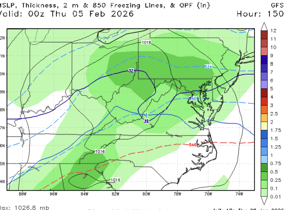
-
-

February 2026 Medium/ Long Range Discussion: Buckle Up!
mitchnick replied to Weather Will's topic in Mid Atlantic
Yeah. I deleted my post as it popped up as soon as I made it. -

The “I bring the mojo” Jan 30-Feb 1 potential winter storm
KChuck replied to lilj4425's topic in Southeastern States
Same thing in Buffalo in the mid 60s (West Seneca) -
February 2026 Medium/ Long Range Discussion: Buckle Up!
stormtracker replied to Weather Will's topic in Mid Atlantic
Nice, we lose thermals. Surface wise anyway. Obviously -
I enjoy looking at Mt Leconte’s NWS forecast… .
-

Richmond Metro/Hampton Roads Area Discussion
overcautionisbad replied to RIC Airport's topic in Mid Atlantic
DT says his first call map will be out by 10:30 pm and that there will obviously be changes. Explains there almost always is between his 1st guess and 1st call. Says he's had the same process for 15 years. -
SSW events are hard to predict sometimes. Later in winter we go, more chance to see winter weather is from ULL, at least in west tennessee. Yall in east tennessee have a better chance since you are higher elevations.
-
 So does Ukie
 -
Richmond Metro/Hampton Roads Area Discussion
jlewis1111 replied to RIC Airport's topic in Mid Atlantic
That doesnt look like a nw trend to me -

Arctic Hounds Unleashed: Long Duration Late January Cold Snap
dendrite replied to WxWatcher007's topic in New England
Lol wtf. -
Was just looking at that too. Won’t be too bad to remember really. Dashes - going to be hefty. Lines - going to be rowdy. Hatched - Oh shit.
-
February 2026 Medium/ Long Range Discussion: Buckle Up!
stormtracker replied to Weather Will's topic in Mid Atlantic
hmm
-
.
- 425 replies
-
- 1
-

-
- extreme cold
- snow
- (and 1 more)
-

The “I bring the mojo” Jan 30-Feb 1 potential winter storm
buckeyefan1 replied to lilj4425's topic in Southeastern States
You're not far off there 5' 1" and 105lbs so once those winds reach warning criteria, I need cinder blocks for shoes -

February 2026 Medium/ Long Range Discussion: Buckle Up!
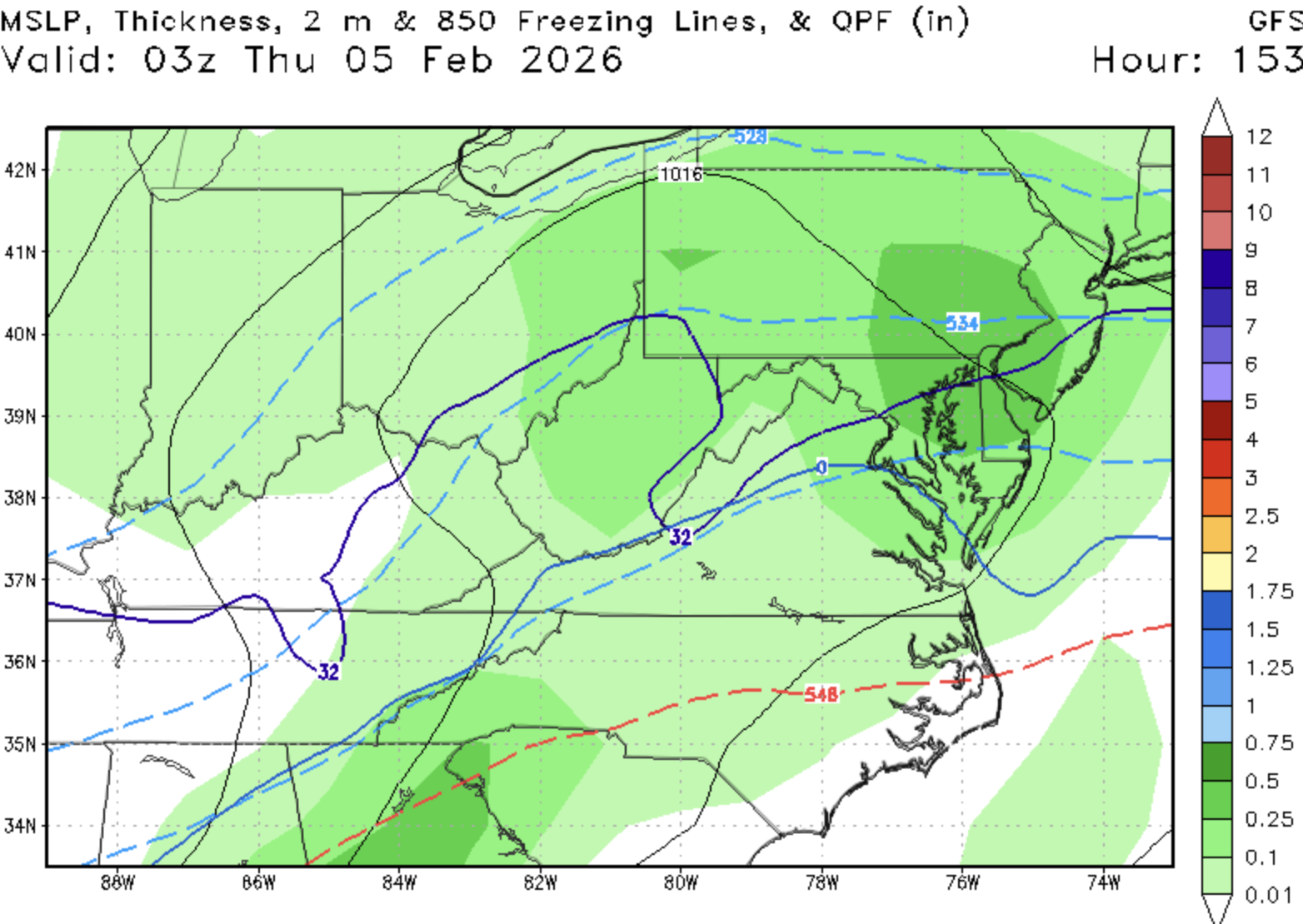
bncho replied to Weather Will's topic in Mid Atlantic
looks like about 5-10”, look at the QPF map above