All Activity
- Past hour
-

Possible Record Breaking Cold + Snow Sunday 1/25 - Tuesday 1/27
weatherpruf replied to TriPol's topic in New York City Metro
does that really mean anything either....this is days away; best we can say is there is some weather ahead. that's all. be prepared either way. it does not hurt to be prepared. -
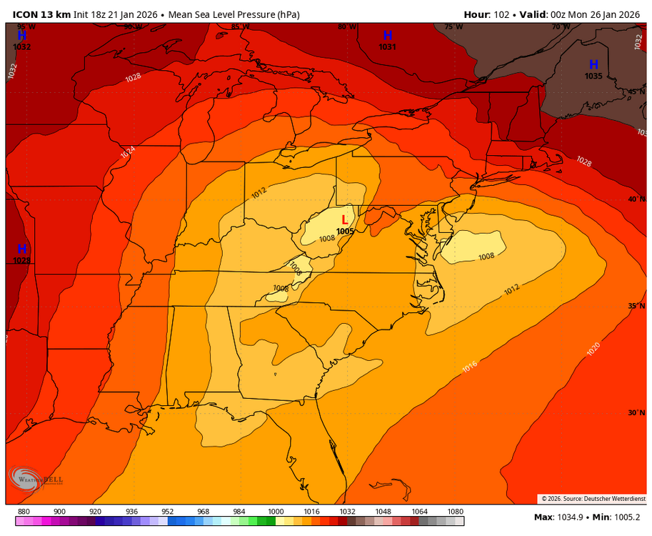
WB 18Z ICON takes a primary into northern WV, transfer is north of us and we basically get dry slotted.
-
Icon doesn’t even make sense. Has the primary in eastern TN and has us mixing to Maryland line. CMC has the primary in Kentucky at same time and it’s still snowing in DC.
-

January 24-26: Miracle or Mirage JV/Banter Thread!
dailylurker replied to SnowenOutThere's topic in Mid Atlantic
I'm looking for an Airbnb in Oswego County for this weekend. Suddenly looks amazing up there lol -

Central PA Winter 25/26 Discussion and Obs
paweather replied to MAG5035's topic in Upstate New York/Pennsylvania
We had the same in the 1993 super storm where sleet fell but it didn’t hurt amounts plus a good front end thump before any changeover would occur. -

January 24-26: Miracle or Mirage Thread 2
StormyClearweather replied to mappy's topic in Mid Atlantic
Moving on... Anyone have thoughts on the RGEM and if trends were good or bad? -
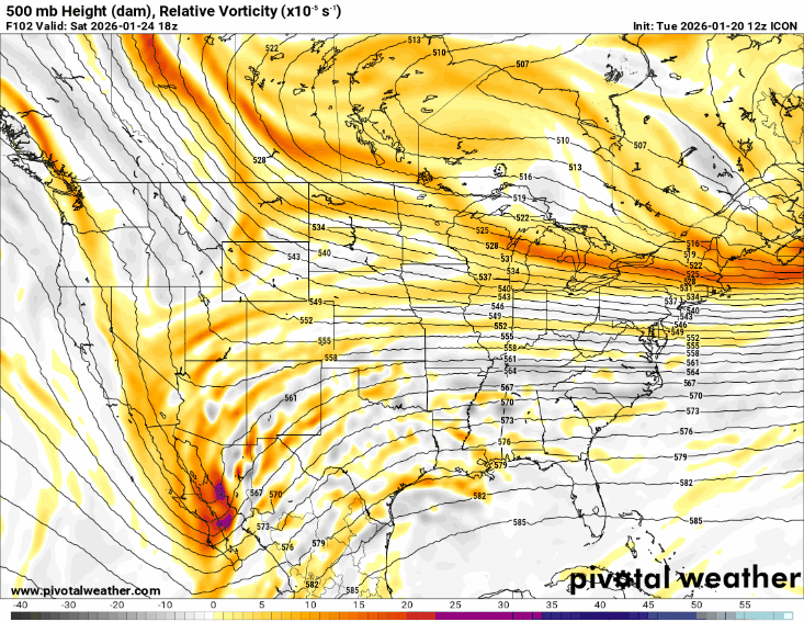
You can see early on below. That northern stream piece in Canada is right over the top and phases way to early and easy. Need that piece further east and out in front. 18z is the first image.
-
Early, early call if the foreign models are correct: 4-6" in Chicagoland; 6-8" across Michiana. Add an inch or two for lake-enhancement if it applies to your backyard. Obviously, the bigger the totals, the more south and east you get.
-

Winter cancelled/uncancelled banter 25/26
Tar Heel Snow replied to Rjay's topic in New York City Metro
Congrats Quebec City -
Sure, maybe it’s about to lead the way for the first time ever and technically it’s another piece of guidance, but no one ever even used to post this model back in the day and I have always thought it was just posted something to look at after the NAM while we wait for the GFS. I never take it seriously.
-
ICON took a step north i believe, or QPF is lower, hacked off about 3-4ins from the LV from 12z to 18z
-
 no i look at icon for one specific reason 2m temps... that's the only thing that it could be useful. it is the worst model of all
 -

January 24-26: Miracle or Mirage JV/Banter Thread!
Interstate replied to SnowenOutThere's topic in Mid Atlantic
The main thread is a mess... more banter there then in here. -
Looking up at Canada at hr66 or so on the ICON and the NS just is way different than 12z. Have to see if that energy presentation is real at all.
-
Central PA Winter 25/26 Discussion and Obs
paweather replied to MAG5035's topic in Upstate New York/Pennsylvania
What’s wrong with it? -
If you look at the total QPF map on the ICON (especially if you compare runs) you can see why it's a junk model. Weird patches and holes all over the place compared to the varsity models. IDK why I'm even bothering to dissect it. On to the GOOFY
-

Possible Record Breaking Cold + Snow Sunday 1/25 - Tuesday 1/27
Wxbear25 replied to TriPol's topic in New York City Metro
Relative to its 12z run, it was noticeably southwest The biggest change was how it handled the energy in Canada. The whole orientation of the trough north of the border changed between the 12 and 18z run ultimately, it’s that piece, more so than the southern stream itself, which will dictate how far north this comes -
Possible Record Breaking Cold + Snow Sunday 1/25 - Tuesday 1/27
weatherpruf replied to TriPol's topic in New York City Metro
i don't know how, after all this time, folks can confidently talk about a foot plus of snow when we have seen multiple cases of things changing radically even the day before. this was entirely predictable. it might still be wrong. it's only wednesday ffs. -
 By tomorrow it will be all rain
 -

E PA/NJ/DE Winter 2025-26 Obs/Discussion
RedSky replied to LVblizzard's topic in Philadelphia Region
Fat flakes graupel mix -

Central PA Winter 25/26 Discussion and Obs
Eskimo Joe replied to MAG5035's topic in Upstate New York/Pennsylvania
18z ICON appears to get the sleet/snow line up the PA Turnpike. Keeps totals below 10" along the Mason-Dixon counties. -
Yes if Euro AI follows suit than it'll be very concerning if you want snow! GFS flip flops the best model now is euro ai in my opinion!
-

“Cory’s in LA! Let’s MECS!” Jan. 24-26 Disco
mahk_webstah replied to TheSnowman's topic in New England
LBChickens? -
 Still 6+ almost entire subforum
 -

“Cory’s in LA! Let’s MECS!” Jan. 24-26 Disco
cleetussnow replied to TheSnowman's topic in New England
Not surprising you got hit with a bag of dicks for posting that map. Good luck though. No weenie from me.


