All Activity
- Past hour
-
When is the last time it snowed on New Year's here?
-
 There was no storm 14 and barring the unforeseen the above scoring table (ignore the potential scores in brackets) will be FINAL CONTEST SCORING. Congrats to Retrobuc with the highest score 97.5 closely followed by StormchaserChuck (97) and Cardinalland (96.5). Will do it all again in 2026, deus volente.
 -
Light freezing rain, with a couple snowflakes mixed in . 27.3°
-
5 tornado warnings, possible tornado near Jeffersonville/Fairfield Illinois
-
Hence little Alex.
-

Ice Ice Baby December 28-29 Storm Discussion
ineedsnow replied to Baroclinic Zone's topic in New England
limited qpf and fast movement equals meh I think.. atleast here -
-

Ice Ice Baby December 28-29 Storm Discussion
Torch Tiger replied to Baroclinic Zone's topic in New England
hope the ice overperforms ! -
An inch is something.
-
Ice Ice Baby December 28-29 Storm Discussion
Roger Smith replied to Baroclinic Zone's topic in New England
The way this is rushing in with a spike of warming to follow, I would cut most of those ice accretion forecasts in half and the real problem is likely to be ponding followed by a rapid freeze by late afternoon. It's going to be a nasty mess in many areas by late Monday. -
One of the worst gfs runs of my lifetime
-
The Cedar Rapids airport gusted to 63 mph.
-

Ice Ice Baby December 28-29 Storm Discussion
Damage In Tolland replied to Baroclinic Zone's topic in New England
We all are -
18z Euro has the NYD clipper with C-1” across the sub-forum.
-
Ice Ice Baby December 28-29 Storm Discussion
ineedsnow replied to Baroclinic Zone's topic in New England
I'm jealous of them.. thinking .10 to .25 here -

Ice Ice Baby December 28-29 Storm Discussion
dendrite replied to Baroclinic Zone's topic in New England
We still usually run moist lapse rates under the inversion. The 1k hills are almost always colder in icing setups. -
-
So far

-
So far

-

December 2025 regional war/obs/disco thread
WxWatcher007 replied to Torch Tiger's topic in New England
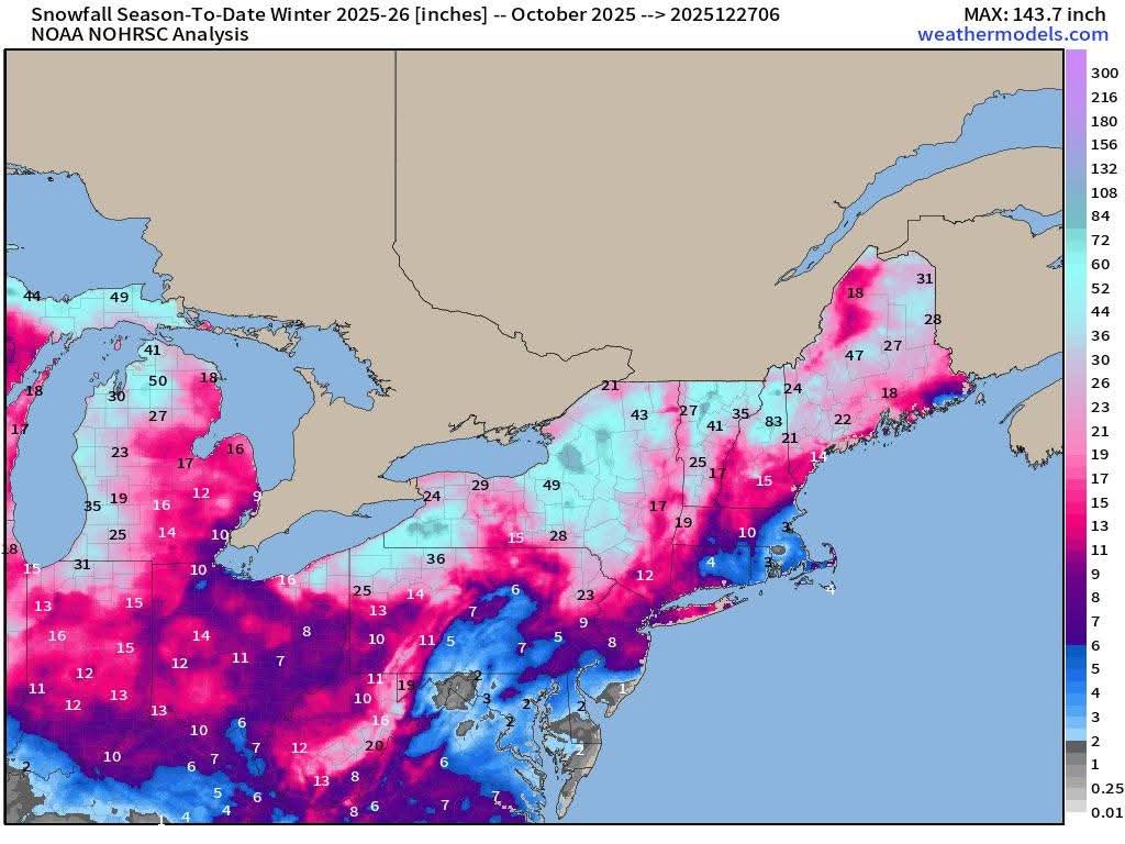
BDR and GON probably the only places in SNE well above snow climo lol. -
Its gotten weird in here. You can post about what a model shows and if it's not positive people will slap a weenie on it.
-

E PA/NJ/DE Winter 2025-26 Obs/Discussion
Ralph Wiggum replied to LVblizzard's topic in Philadelphia Region
I know, just thought it was comical to see after hearing all day how epic the pattern is going to be at that same time. Gefs completely different probably. -
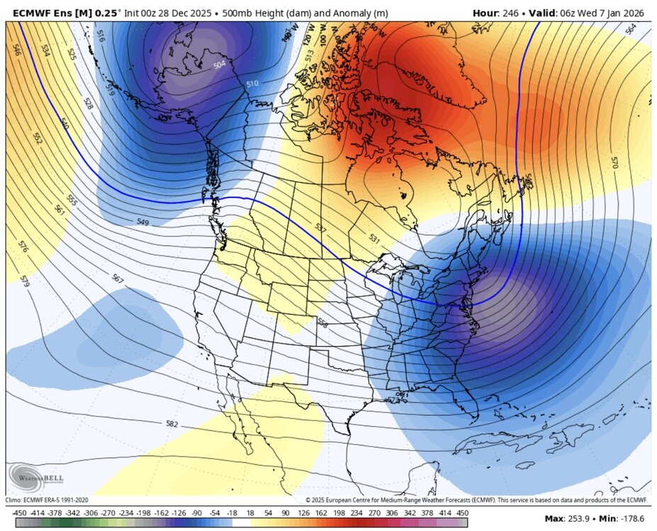
Even the Euro at day 5 ain't great.
-
I made some post but at this time I don't see anything significant. I believe as we head further into January we see a better pattern for getting snow. We need the cold air back in here first and foremost.
-
Ice Ice Baby December 28-29 Storm Discussion
Damage In Tolland replied to Baroclinic Zone's topic in New England
Why wouldn’t it be the lower elevations ? Why would the hilltops do better in CAD?