All Activity
- Past hour
-

Central PA Winter 25/26 Discussion and Obs
mahantango#1 replied to MAG5035's topic in Upstate New York/Pennsylvania
ABC27 going on the lower side while my NWS is 15-22 snow -
Yeah I’d feel good with 12-18 forecast but not good about brushing 18”+ over anyone. I do think the south shore and Cape Ann have a pretty decent shot though with the extra OES enhancement. Still uncertain about how efficient monday is….on one hand, we’re synoptically dryslotted, but OTOH, you are literally in the DGZ sfc-700mb so it might not matter that much if you can generate some steady light precip…you could stack another 4-6” with maybe a quarter inch of QPF.
-
I had almost 10" of cold smoke last January. No mix, no drama. Just a beautiful snow followed by cold. I'm just frustrated as always watching pa get crushed by our storm lol
-

Pittsburgh/Western PA WINTER ‘25/‘26
SteelCity87 replied to Burghblizz's topic in Upstate New York/Pennsylvania
As someone who works overnight the hardest part about this storm may be how I will not miss the morning/afternoon show lol. -
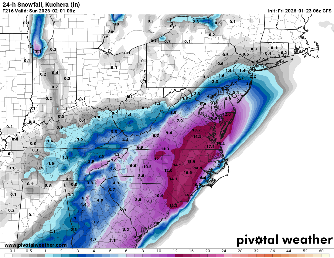
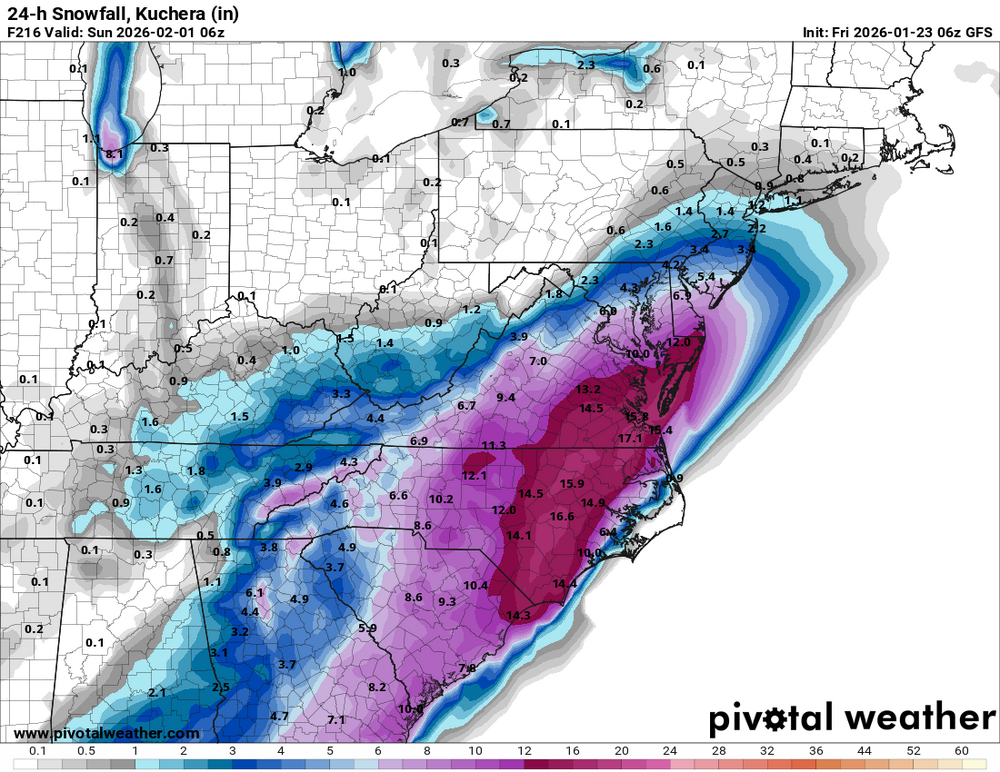
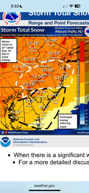
How do they come up with these maps? I ask because how it has that tear drop of 12" over Dover Delaware. I've never seen that before.
-
probably why ALY took totals down a bit here, and I'm still sticking with 10-14 here anyway, we'll see how the next 24 hours look model wise, but no closed low has me concerned about long duration and CCB type snow of any real accum..
-
That may be, but your backyard is still well within the 8-10” range before a flip. Of course that could still change, but you haven’t received that much in a single storm in 10 years.
-
Now the GFS gives southern Louisiana across Mobile, and all of the Florida panhandle 8-12 inches of snow with 0 warm nose issues 150 miles north of the low. Yet here we see 850s shoot to 50 degrees with a low 1000 miles south of us.
-
That would be a KU blizzard
-
Next sunday
-
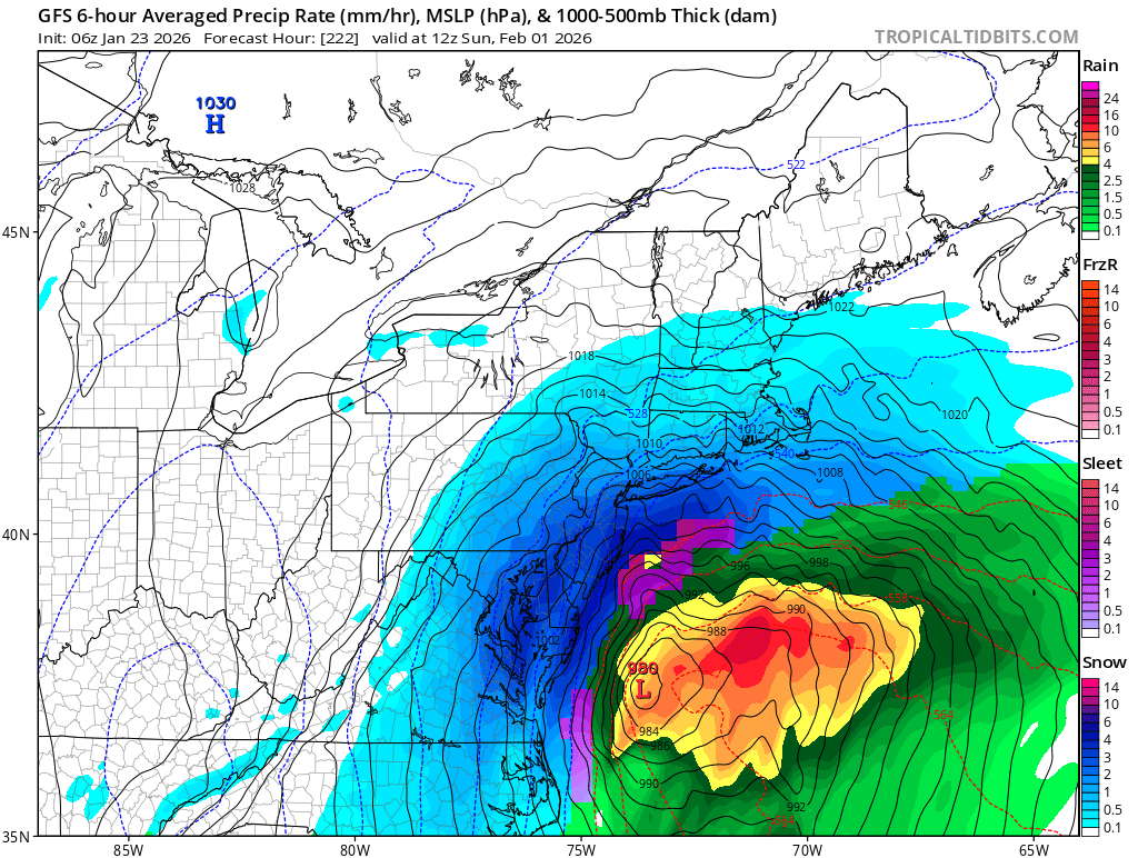
6z GFS for this 24 hr period and its still snowing in some spots. Not taken literally cause its next weekend but something to watch again... lol
-

Possible Record Breaking Cold + Snow Sunday 1/25 - Tuesday 1/27
MANDA replied to TriPol's topic in New York City Metro
Mt. Holly cut back totals over SNJ.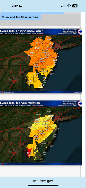
-

E PA/NJ/DE Winter 2025-26 Obs/Discussion
Newman replied to LVblizzard's topic in Philadelphia Region
6z GFS is big time for Feb 1 -
Damn….this isn’t even all the way out there in fantasy land.

-
Forky likes that storm
-
Holy crap at the 06z GFS fantasy storm.
-

Pittsburgh/Western PA WINTER ‘25/‘26
Ahoff replied to Burghblizz's topic in Upstate New York/Pennsylvania
Looks like everything held overnight. Good stuff. The winter storm warning says 10-14”. -
My forecast now calls for 2-4 inches of snow, plus .2-.4 zr. No warning issued though.
-
Updated percentage chance of hitting or exceeding 8” snowfall before flipping. For reference, DCA is at the 50% threshold.
-

“Cory’s in LA! Let’s MECS!” Jan. 24-26 Disco
moneypitmike replied to TheSnowman's topic in New England
Neither Jeff nor I even have a watch up. There's always this though from the GYX AFD: The mere proximity to this moisture advection will mean a powerful conversion when the cold airmass overhead can support snow to liquid ratios north of 15 to 1. NBM mean brings values towards 18-20 to 1 into the region. -
It's pretty clear that DC and east is going to be a massive sleet bomb. Such a bummer. Record cold and still can't snow lol.
-

MO/KS/AR/OK 2025-2026 Winter Discussion
rockchalk83 replied to stormdragonwx's topic in Central/Western States
Feels like Lucy pulled the football back on us in S KS overnight. We went from sharing in the big totals with you guys to the southeast, to having 6-8 inches. Hoping for a slight northward trend, but I think the models finally have a good grasp on the Arctic air and track of the second wave, so it probably won't happen. Bummer. -
Thank you for showing a Mid-Atlantic view.
-
6z GFS has the storm for next weekend to. CMC ensembles for that potential as well
-
“Cory’s in LA! Let’s MECS!” Jan. 24-26 Disco
moneypitmike replied to TheSnowman's topic in New England
New Mattapoisett forecast calls for a change to sleet Sunday nigiht. Too bad we can move the mix line north but the qpf field isn't moving with it. Sunday Night Snow before 3am, then sleet. The snow could be heavy at times. Low around 21. East wind 10 to 14 mph, with gusts as high as 29 mph. Chance of precipitation is 100%. New snow and sleet accumulation of 4 to 8 inches possible.