All Activity
- Past hour
-
 Move it all north.
 -
 No more goddamn rain please! Praying for a “congrats Dendrite” outcome.
 -
Dear Lord that would suck.
-
 Steined with 2-3".
 -
Rainy day here. Picked up 1.14" for the day with a high of only 76. 3.85" for the week and 6.45" for the month.
-
Perfection this evening too. Nice to get a stretch of nice porch evenings during the weekend for those that are still doing the weekday grind.
-
I’m heading to Spain for three weeks culminating with the eclipse in Mallorca. It’s going to be 100+ for the first week but I’m looking forward to a real feel less than actual temps.
-
And possibly less injured arms. I feel like Albernaz has mismanaged the pitching staff all year, but I don’t care anymore. He might end up being a good manager, but I still think the front office goofed going with an unproven guy with this team.
-
.thumb.gif.f92b16c631a1d15d405ed77b33f0710d.gif) wish we could get that. hopefully with convective processes models are smoothing too much, and it's like 10-15" for BOS
wish we could get that. hopefully with convective processes models are smoothing too much, and it's like 10-15" for BOS -
 Get that max north. I want divorces In Newfound
 -
-
Highs will generally reach the lower 80s through much or all of the remainder of July. The warmest spots could reach the middle 80s on occasion. Some showers or thundershowers are possible Tuesday afternoon into Wednesday. The ENSO Region 1+2 anomaly was +3.6°C and the Region 3.4 anomaly was +2.1°C for the week centered around July 15. For the past six weeks, the ENSO Region 1+2 anomaly has averaged +3.20°C and the ENSO Region 3.4 anomaly has averaged +1.82°C. The ongoing strong El Niño will continue to strengthen through the summer. The SOI was -29.61 today. The preliminary Arctic Oscillation (AO) was +1.591 today. Based on sensitivity analysis applied to the latest guidance, there is an implied near 82% probability that New York City will have a cooler than normal July (1991-2020 normal). July will likely finish with a mean temperature near 76.6° (0.9° below normal). Supplemental Information: The projected mean would be 0.1° above the 1981-2010 normal monthly value.
-
 Yeah looks like another good soaker on the way down there.
 -

2026-2027 Super El Nino
raindancewx replied to Stormchaserchuck1's topic in Weather Forecasting and Discussion
Locally, almost everything I'm seeing implies a colder winter than 2023-24. For Nov-Jan, a colder Atlantic (AMO) is correlated almost everywhere with colder US temps. That reverses later, but its important early on. -
 Didn't we just do that 2 weeks ago and ended up with 2-3" ?
 - Today
-

2026-2027 Super El Nino
snowman19 replied to Stormchaserchuck1's topic in Weather Forecasting and Discussion
You’re right, I’m not going to split hairs but this event is much warmer in region 1+2 than 2015 was but I honestly don’t think it’s going to matter with how strong this thing is going to get. Moot point. By the end of November we are going to have a completely overwhelming beast of an El Niño on our hands and I think we blow away records with the traditional ONI, RONI and the MEI -
Left handers coming up in the 8th inning. 88 pitches. Why pull Rodgers? Dumb move. No way to really know but with Buck it feels like a + 3 -5 more victories in the win column. This season.
-
Yes was looking on x and saw there was a model of a trough taking a nose dive from somebody it is summer time after all .
-
It looks like the ring of fire pattern could return. I was looking to see if any MCS possibilities were on tap.
-
I also heard between Sunday Monday timeframe could potentially be dealing with a mcs possibly https://x.com/0meterchasers/status/2081018000312881519?s=46&t=nTdsbQZkQMPkUI3zGjAXJg .
-
D4 yellow highlighted slight risk issued https://www.spc.noaa.gov/products/exper/day4-8/archive/2026/day4-8_20260725.html .
-
.46'' this morning Up to 11.30'' for the month.
-
If I get into the 50s tonight, that will be something like 4/6 days in the 50s at the hottest time of year! Also Billings, MT just hit 111 a few weeks ago, breaking their all time high of 108.
-

2026-2027 Super El Nino
LakePaste25 replied to Stormchaserchuck1's topic in Weather Forecasting and Discussion
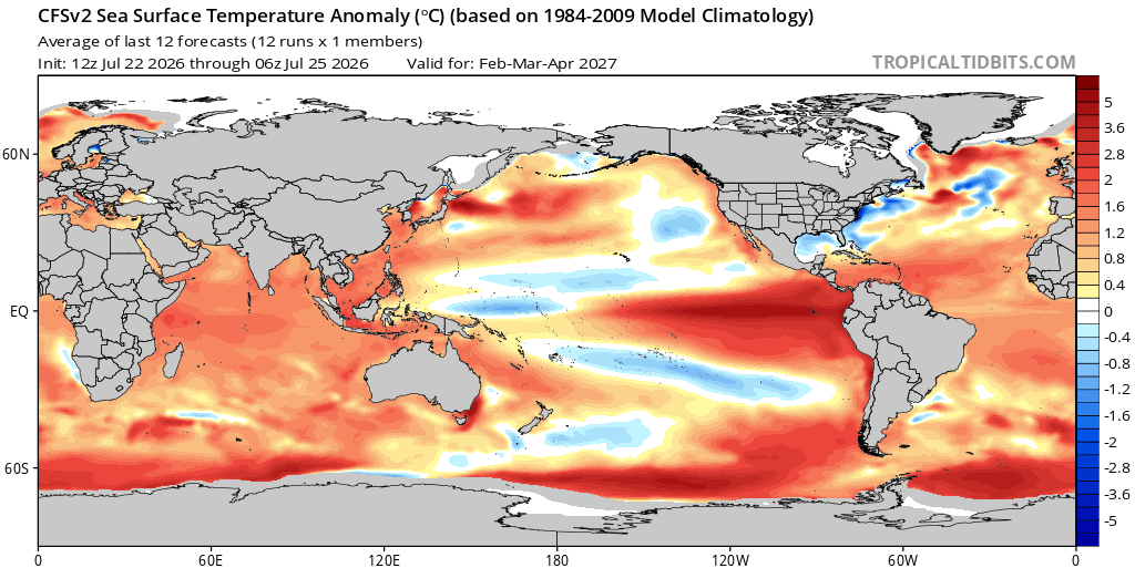
CFS does have a 1983/1998 look to it, where we get - anomalies to the dateline. I don’t worry too much about Nino 1+2 or even much of Nino 3. What matters most to me is how far east we see suppressed convection. You’re pretty much never going to see heavy convection near 1+2 anyway.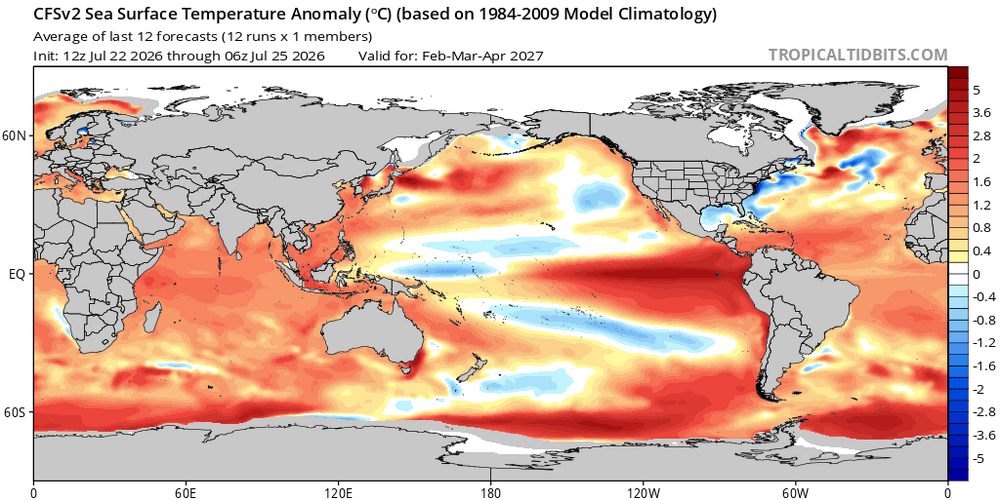
-
As expected. Highs hovering around 80 in the area. Point fail.