All Activity
- Past hour
-
I think the storm next weekend is real. Not atypical to have a storm as the transition event towards a warmer pattern.
-
 12z euro ai has a good track only problem is the freezing line way north of Montreal lol
 -
 That’s damn impressive . This winter is legit
 -
 It will be in the Carolinas soon enough if that continues.. Wahh wahhh
-

Winter 2025-26 Medium/Long Range Discussion
DocATL replied to michsnowfreak's topic in Lakes/Ohio Valley
Virginia is for snow lovers. -
Feb 10-11 Mid Week Minor Event - Ride the hot hand?
Damage In Tolland replied to HoarfrostHubb's topic in New England
-

Winter Storm Threat *Technical* Discussion. No Op Run PBP or Snow maps
CAPE replied to CAPE's topic in Mid Atlantic
-

Winter Storm Threat *Technical* Discussion. No Op Run PBP or Snow maps
psuhoffman replied to CAPE's topic in Mid Atlantic
Is it possible that for once “what could go right” happens instead of…what we’re used to -
And if the storm trends more amped, there is nothing in its way to stop it from advancing as far north as possible. We need cold air reinforcement in order to do well in a setup like this.
-

Winter Storm Threat *Technical* Discussion. No Op Run PBP or Snow maps
SnowenOutThere replied to CAPE's topic in Mid Atlantic
Honestly with 12z I'm not even sure if you could call the bit of low pressure in the Ohio valley a primary. From how I'm seeing the setup it appears to be an extension of the main low pressure system across the southeast states. -

Friday February 6 FROPA / WINDEX small event
dendrite replied to HoarfrostHubb's topic in New England
They were pounding when all of those 10-12” reports came out yesterday mid morning. I honestly expected to see more 15-18” obs. Those who cleared probably did, those who let it set probably stuck around that 12-13” mark. -
But they show a 12 to 16" color zone?
-
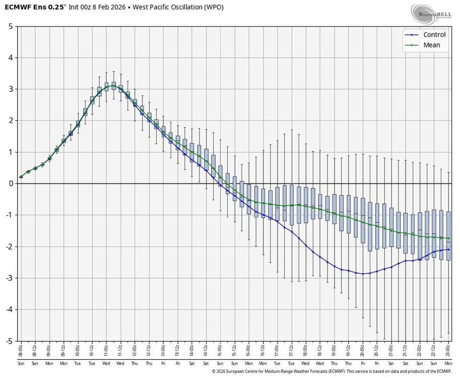
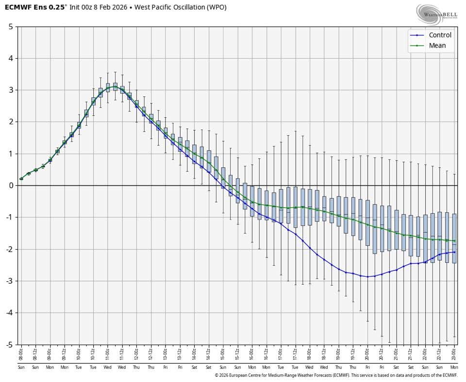
WPO is going back negative so expect more cold air as we head into late February.
-

Pittsburgh/Western PA WINTER ‘25/‘26
RitualOfTheTrout replied to Burghblizz's topic in Upstate New York/Pennsylvania
I thought about it, but Tuesday with the melt / residual salt the road spray will just cover my car again anyways. -
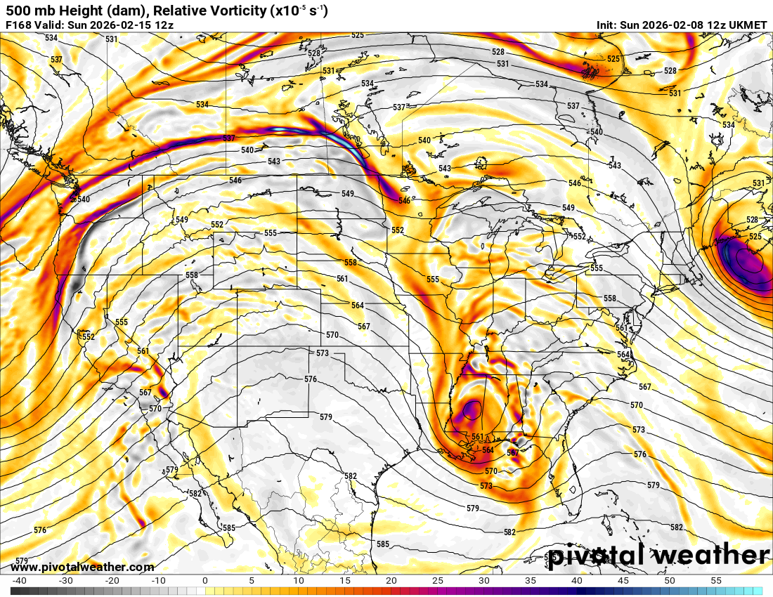
 Also the 12z UKMET looks half decent to my eyes. Doesn't go out far enough to see what happens. However, closed off 500mb low, over central MS/AL, neutral (going neg soon maybe) on the last panels on pivotal. Some CAD in place but not super cold in the mid-atlantic. One thing I'm trying to learn about. How does one predict what will happen to the cold air in place based on 500mb charts?
-

Winter Storm Threat *Technical* Discussion. No Op Run PBP or Snow maps
stormtracker replied to CAPE's topic in Mid Atlantic
This thread does kinda dilute the brand. I need CAPE to balance the irrational and unbalanced. -
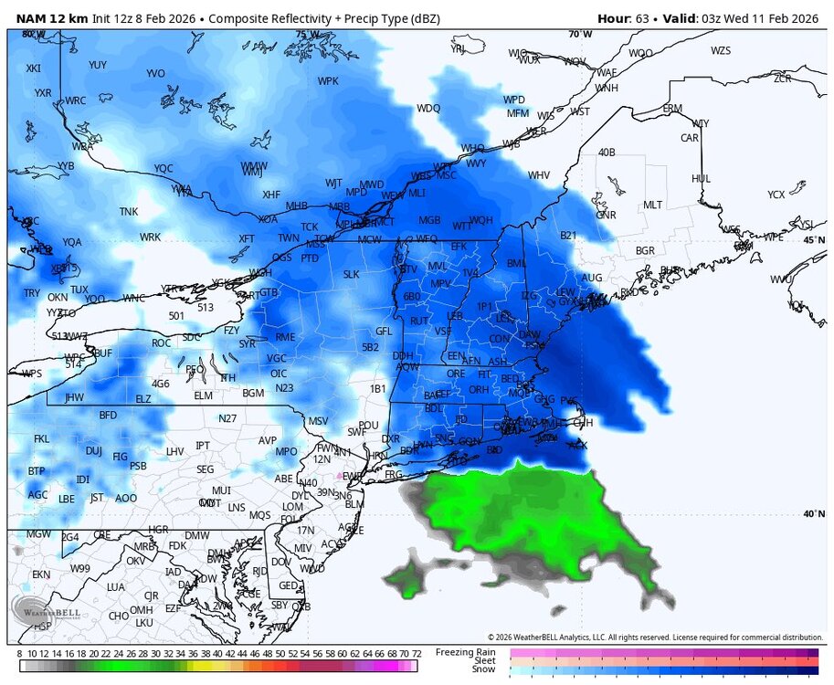
 Gefs majority keep it south.
.thumb.png.0af56133cfc04f497ee6b0a513fa92ed.png)
-
Winter Storm Threat *Technical* Discussion. No Op Run PBP or Snow maps
CAPE replied to CAPE's topic in Mid Atlantic
Yes and much different than 6z when the primary went to Cleveland and the secondary formed over NJ. -
Much like summer thunderstorm rainfall totals, these meso-scale banding events can have extreme differences across very small distances; think lake effect snows??? I would dismiss it off hand?
-
Went from a congrats Chicago cutter with us blasting into the warm sector to a congrats Pittsburg Ohio valley low setup. Big change is also the placement of the high from promoting the S return flow/torching to more of CAD look that allows us to maybe get a thump of snow.
-

Winter Storm Threat *Technical* Discussion. No Op Run PBP or Snow maps
NVAwx replied to CAPE's topic in Mid Atlantic
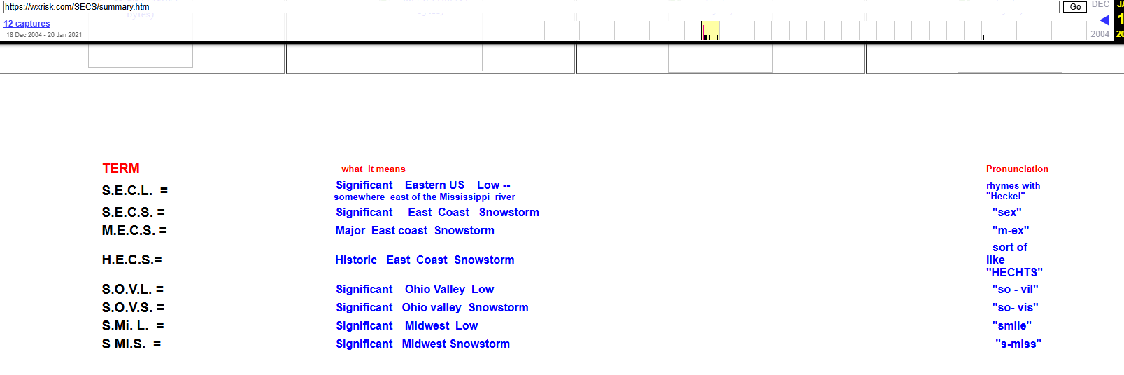
A good one from CTP: https://www.weather.gov/ctp/SnowStormTypes Miller A's are classic. Miller B's are trickier and can shaft many of us, but tend to produce well for areas NE of Baltimore. https://en.wikipedia.org/wiki/Miller_classification https://www.13newsnow.com/article/weather/severe-weather/noreasters-different-types-miller-a-miller-b-snowstorm-blizzard-winter-weather/291-945f5b59-6569-4dc9-b3a8-40b8921efade
-

Winter 2025-26 Short Range Discussion
madwx replied to SchaumburgStormer's topic in Lakes/Ohio Valley
And the least surprising post of the year goes to -
Way too early to say
-
Oh so the previous claim of 19 days was incorrect. Still an impressive streak but they won’t be breaking that.
-
This is annoying having to read 2 threads now….cant u guys just post in the main thread and put the posters u dont wanna read on ignore?


.png.2601e80f18bb27b58bd3b69992797bdb.png)