All Activity
- Past hour
-
 Winds gusting to 46 at ISP and JFK. Newark 48.
 -
A notice has gone out today that states the FAA contract to a 3rd party vendor for 58 AWOS sites in MD/NC is ending today. This means no more METARs over the various NCEP and FAA data lines. This is non-trivial IMHO, esp. b/c it basically takes out much of the AWOS network in MD/NC. The AWOS are not being decommissioned, just NADIN service, which routes the METAR to WMSCR and then NCEP and the FAA lines for all to see, is going away. All these sites have been available for ~20 years. Not good for the HRRR and RRFS, among other things. List is below: K0W3 Churchville MD K1A5 Franklin NC K24A Sylva NC K2G4 Oakland MD K2W6 Leonardtown MD K7W6 Engelhard NC KACZ Wallace NC KAFP Wadesboro NC KASJ Ahoskie NC KCBE Cumberland MD KCGE Cambridge MD KCGS College Park MD KCPC Whiteville NC KCTZ Clinton NC KDMW Westminster MD KDPL Kenansville NC KEDE Edenton NC KEHO Shelby NC KESN Easton MD KETC Tarboro NC KEXX Lexington NC KEYF Elizabethtown NC KFDK Frederick MD KFFA Kill Devil Hills NC KFME Fort Meade MD KFQD Rutherfordton NC KGEV Jefferson NC KGWW Goldsboro NC KHBI Asheboro NC KHNZ Oxford NC KHRJ Erwin NC KIPJ Lincolnton NC KISO Kinston NC KIXA Roanoke Rapids NC KJNX Smithfield NC KJQF Concord NC KLHZ Louisburg NC KMCZ Williamston NC KMQI Manteo NC KMRN Morganton NC KMTN Baltimore MD KMWK Mount Airy NC KOCW Washington NC KONX Currituck NC KPGV Greenville NC KRCZ Rockingham NC KRHP Andrews NC KRUQ Salisbury NC KSCR Siler City NC KSIF Reidsville NC KSUT Southport NC KSVH Statesville NC KTDF Roxboro NC KTTA Sanford NC KUKF North Wilkesboro NC KVUJ Albemarle NC KW29 Stevensville MD KW40 Mount Olive MD
-

Spooky Season (October Disco Thread)
Ginx snewx replied to Prismshine Productions's topic in New England
Yep and so it begins. Love to see it . -

2025-2026 ENSO
WestMichigan replied to 40/70 Benchmark's topic in Weather Forecasting and Discussion
2013-2014 stands out like a sore thumb in the middle of that data. Makes you realize just how much of an anomaly it was. -

Spooky Season (October Disco Thread)
powderfreak replied to Prismshine Productions's topic in New England
Already mixing up top. Wet snow (white rain) and 33.5F top of the Quad. Thinking 3-6” of dense snow possible above 2,500ft. Models have a lot of upslope precip and all parameters for heavy upslope precipitation are met… near saturated from SFC to ridgeline, H85 winds 25kts< and cross barrier, vertically stacked low traveling near FVE, precip duration of 12+ hours. Temps and snow growth are pretty poor though. Big precip is a lock, snow will likely be 6-7:1 ratios overnight with heavily rimed or small needles. -
With that pattern in late November into December, Local ski resorts should be able to get going the first half of December. Maybr the first week of December for places like Wisp and 7 springs and mid December for White tail and Liberty.
-
Autumn Blaze Maple in the backyard is poppin’…
-

Major Hurricane Melissa - 892mb - 185mph Jamaica landfall
GaWx replied to GaWx's topic in Tropical Headquarters
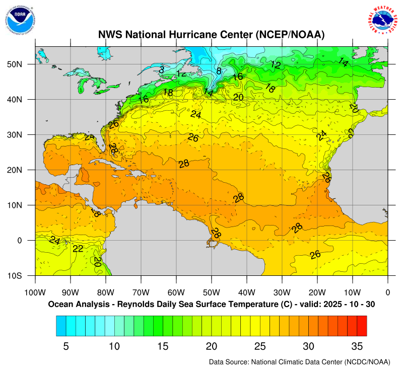
Here are before and after SSTs to see how much Melissa cooled the ocean on and near its track: 10/24/25: 10/30/25: So, it cooled only ~1C/2F around Jamaica/E Cuba (from slightly over 30C to near or slightly over 29C). Unfortunately, that wasn’t nearly enough to keep Melissa from exploding. Much of the area around the Bahamas also cooled some (perhaps ~0.5C/1F) but the full cooling may have to wait til the 10/31 SST map. Also, Melissa wasn’t as strong and was moving much more quickly through the Bahamas thus likely meaning less cooling influence. In contrast, note that most of the Gulf and far W Caribbean cooled hardly at all, if any, as they were too far west to be cooled by Melissa.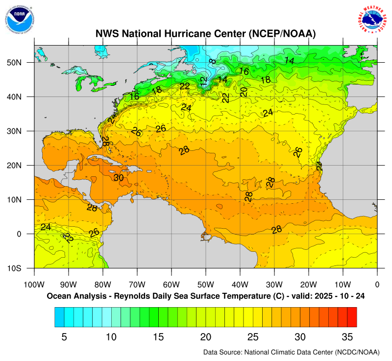
-
https://sports.yahoo.com/nfl/breaking-news/article/ravens-fined-100k-by-nfl-for-violating-injury-report-policy-regarding-lamar-jacksons-week-8-status-175454372.html
-

Spooky Season (October Disco Thread)
mreaves replied to Prismshine Productions's topic in New England
-
Ha - He did an update today to look at the years as well
-

Spooky Season (October Disco Thread)
dryslot replied to Prismshine Productions's topic in New England
So much weather to discuss, The heating is clogging the thread........... -
 Branches down SC NJ
 -
November 2025 general discussions and probable topic derailings ...
Ginx snewx replied to Typhoon Tip's topic in New England
Not this year leaves are mostly gone and after tonight see ya. -

Spooky Season (October Disco Thread)
Typhoon Tip replied to Prismshine Productions's topic in New England
The low actually bottomed out just below 980 mb up there ... pretty good. -
November 2025 general discussions and probable topic derailings ...
Ginx snewx replied to Typhoon Tip's topic in New England
First substantial snows in the 2500 plus zones in the mountains. 4 to 5 inches seem possible -
 WxWatcher007 changed their profile photo
 -
Spooky Season (October Disco Thread)
Ginx snewx replied to Prismshine Productions's topic in New England
Snow in them hills tonight? -
 not sure it would have happened here yesterday-the winds/rain really ramped up from 5-7pm and roads were flooded
 -

Spooky Season (October Disco Thread)
Great Snow 1717 replied to Prismshine Productions's topic in New England
You'd freeze at my place lol...70 ain't happening lol -
Spooky Season (October Disco Thread)
Ginx snewx replied to Prismshine Productions's topic in New England
Saving money is fun. I can use money saved to make more home improvements. Pellet stove might be my best investment yet. Yea the Pope is right about south side but when you live on the ne side of a hill the sun rises late and sets early and of course its been cloudy. -
If there is one model to sniff out amplification at range, it is the GFS. The Euro won't see it until it late. The GFS nailed the amplification which occurred yesterday. Things look increasingly interesting after next weekend. Sure seems like models are missing on daytime highs(actual reality is colder). It could just be we are hitting our highs at midnight? The thing I really like right now is that we are not going to have erase lots of AN temps over NA. The LR sure has modeling trying to amplify a trough over the eastern half of the US by the end of November, and that trough would bring actual winter temps with it.
- Today
-
A few of us knew you from day 1 and it’s been over 20 years now and you are famous so drop in and say Hi to us little people!! HMP
-

Spooky Season (October Disco Thread)
WinterWolf replied to Prismshine Productions's topic in New England
When it gets cool/cold, If I’m uncomfortable, the heat goes on. When it gets warm/or hot in the spring, If I’m warm, the air goes on. It’s that simple. No set times of year for anything like that. Just want to stay comfortable. -
 yeah, I haven’t heard one person canceling yet. I’m just glad it wasn’t yesterday.
 -
Those rare ones seem tricky! I think you have to try the mountains for lenticular clouds... but I'd be pretty shocked if anyone gets any of those minus maybe the gravity waves.


