All Activity
- Past hour
-
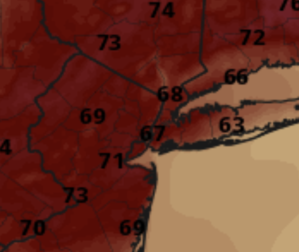
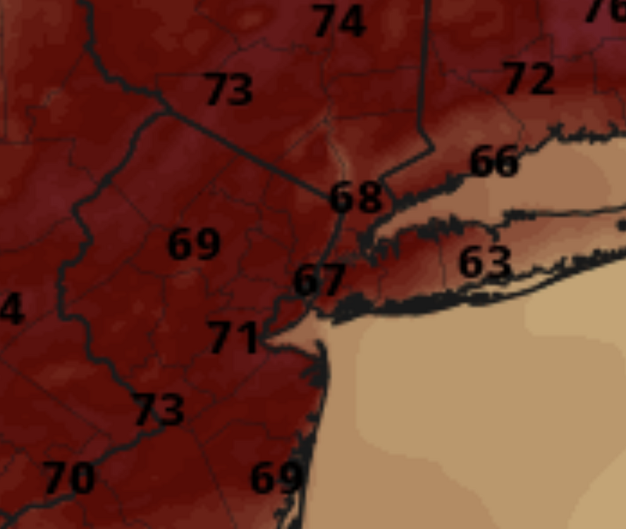
The color scheme on Pivotal is absurd. Nothing about this map says 60s and low 70s. This map looks like it should be 80s and 90s:
-
This is my favorite summer weather. Sunny Morning after an overnight rain, not too hot but still muggy enough to be like morning in Borneo. Smells fresh outside. Unfortunately box turtles love it too, and it was carnage on the back roads on my way to Annapolis this morning.
-
some of these look like big dogs
-
Pretty curious to see how today plays out in this region. Very potent vort max should provide a lot of dynamic support for strong convection, although the mid level lapse rates/instability definitely leave something to be desired (which immediately makes me question the height of the ceiling). Seems a supercell storm mode may be favored though, which given the magnitude of the low level shear should be a cause for some concern.
- 790 replies
-
- 1
-

-
- severe
- thunderstorms
- (and 2 more)
-
The sun has made an appearance. I want it to swallow me whole.
-
Yeah obviously I'm all for getting enough rain for the garden during the spring and summer, but we definitely don't want it to stay wet for too long.As you said, fungal diseases can become a problem when it stays wet for too long. My tomatoes, peppers and eggplants have had some problems with fungal disease in recent years, but I've been spraying them with a biofungicide. It causes the plants to have an immune response and works pretty well. It has significantly reduced fungal disease problems for me. We definitely could use a drying out period after this event tonight into tomorrow. I'm glad we're going to see sunny warm weather next week.
-
Tricky there.
-

2025 Atlantic Hurricane Season
ValpoVike replied to BarryStantonGBP's topic in Tropical Headquarters
This isn’t likely to happen. There is a huge blob of SAL east of the lesser Antilles that will likely be migrating into the gulf ahead of this time period. -
WPC frontal analysis assesses that the front is north of many of us but as a stationary front.
-
Someone posted it on a different site that I saw
-

Central PA Spring 2025
Mount Joy Snowman replied to canderson's topic in Upstate New York/Pennsylvania
Over here it was from about 2:30-3am. I usually check the E-Wall radar first thing in the morning and that goes back six hours, so it covers most of the night after I go to bed. Also, this page from MARFC gives you the ability to check past one-hour (and other time frames) radar estimates. Multisensor Precipitation Estimates (MPE) -
Should be ok here from mid -late morning until later day
-
Oh wow. I wasn't paying enough attention to the overnight wind threat. We'll see what happens. Definitely looks to be a windy system for the end of May. Surface low currently looks to be wrapping up a bit just south of the Kentucky, Ohio, West Virginia intersection.
-
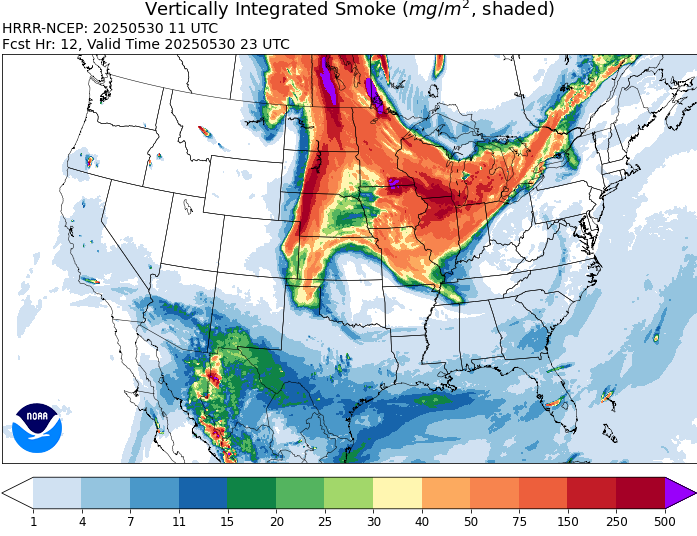
Looks like this may be a pretty high-end smoke event. This is all the way out to wee hours of Monday morning and look at all of that surface-based smoke across the High Plains down into Iowa, Kansas and Missouri. Even parts of the Southeast may see a slight decrease in visibility and possible faint smoky smell. Keep in mind, these model projections wouldn't even factor in any newly ignited wildfires today or over the weekend, and there should be pretty extreme fire weather conditions in place with near record temperatures. Given the likelihood of new fires, this may even be somewhat conservative.
-
Probably 70s out here, but I agree it should be nice. This week was always supposed to be iffy. We'll probably get good weather just in time for the smoke to ruin it
-
def looks thick and not liking the trajectory
-
The costs of homes and autos, including insurance is becoming untenable. If someone's fancy Land Rover gets washed away in a flood, insurance is out 80-100K, which are costs they will ultimately pass on to everyone. Even a minor fender bender can be over 10K in repairs. Many of these homes wrecked in fires and floods are north of a million bucks. But even lower end homes and autos are becoming too expensive to maintain and repair.
-
Looks like about 4 hours - ish of partly - sunny today before clouds come back. We'll see how quickly we can clear out tomorrow. Clouds approaching CPA
-
NAM looks gust this evening as well. I could see some wind advisories for higher elevations being possible.. Would not be surprised for Piedmont as well. I know models can overdo it many times and what actually gets to the surface can be less. Breezy seems likely - how windy is questionable.
-
Probably not, but LWX did mention the threat in its AFD oking at tonight, as the low slowly pulls away, some showers likely linger on the back side of the low as well. One thing of concern is the 850mb wind field on the back side of the low during the pre-dawn hours Saturday morning. Will have to watch for some sneaky strong wind gusts if there is a heavy enough shower to bring that wind down to the surface. The hi-res guidance has a concerning amount of agreement on some high-end wind gusts around 40 to 50 mph potentially reaching the surface, so it is something I am growing increasingly concerned about. This is something to keep an eye on, given that this would occur during a very sensitive time period, being during the overnight. Should this trend continue, a short-duration Wind Advisory may need to be considered. Perhaps if things are still convective in nature, they could be handled with short-fused convective warnings as well.
-
Lol 13z HRRR is loltastically aggressive with a sting-jet feature overnight bringing 50-60mph wind gusts from northern VA through DC and southern MD... No I don't see it getting THAT windy.
-
huh?
-
I don't see that on their Twitter page or main school page
-
According to my weather station, I received about 0.02” of rain right around midnight. .
-
Baltimore County dismissing early because of the flood watch!?