All Activity
- Past hour
-

Fall 2026 Medium/Long Range Pattern Thread
Carvers Gap replied to John1122's topic in Tennessee Valley
OTH, you get to experience the heartbreaks of winter again with us. I am thankful for that! Haha!!!! -
Fall 2026 Medium/Long Range Pattern Thread
Carvers Gap replied to John1122's topic in Tennessee Valley
I kind of suspected this might not be temporary. LR ensembles are showing the ridge parking itself out West. -

Strong Nor'Easter/Hybrid Storm Late September 2026
guinness77 replied to Rjay's topic in New York City Metro
Looks like we’re missing a big bit of moisture off the coast of LI now. Probably headed for Central/Southern Jersey though. -
E PA/NJ/DE Autumn 2026 Obs/Discussion
Albedoman replied to PhiEaglesfan712's topic in Philadelphia Region
METEOROLOGIST’S LONG-RANGE WATCH — IS OUR FIRST REAL SHOT OF FALL COLD SHOWING UP? For those of us in the Lehigh Valley who have been waiting for some genuine crisp fall weather, the extended-range guidance is finally starting to get interesting. The GFS model is beginning to show a potentially much cooler pattern developing around the October 9–11 time frame, with colder air pushing into Pennsylvania and the Northeast. At this distance, I am NOT calling for a freeze yet, and certainly no Frost Advisory or Freeze Warning can be issued this far in advance. But the overall pattern is worth watching. The important signal isn't an exact temperature on one particular GFS run. What meteorologists look for this far out is whether the larger atmospheric pattern begins favoring Canadian air moving southeast, lower dew points, clearing skies and high pressure settling over the region. If those ingredients eventually come together, overnight temperatures can drop very quickly across eastern Pennsylvania. And remember, the Lehigh Valley has some significant microclimates. Temperatures at the airport don't always tell the whole story. Rural valleys, open farmland and sheltered locations can become several degrees colder on a clear, calm October night. Those are the places that could see frost first. So for now, let's call October 9–11 a period to watch for the possibility of our first legitimate frost conditions and perhaps our first real taste of late-fall nighttime temperatures. We will need several more model runs — and especially better agreement among the ensembles — before putting much confidence in an actual freeze. But after what seems like an endless stretch of warm and humid weather, I'll take the signal. I'm ready for those clear 50-degree evenings dropping into the 40s after sunset, the smell of leaves in the air, a fire going in the burn ring, and a glass of wine in hand. Now THAT is fall weather. I'll be watching the GFS and ensemble trends closely over the next week to see whether this colder October 9–11 signal strengthens, disappears, or shifts in timing. Stay tuned — fall may finally be getting ready to make its move in the Lehigh Valley. -
October Comes Early: Late September Multi-Hazard Hybrid Storm
TalcottWx replied to WxWatcher007's topic in New England
Heavy damage after heavy trolling. -
Going to come down to the final game. A Phils win or D-Backs loss and we're in... A
-
WTH is going here https://suno.com/s/XkGmMIhcxeWT6Glx
-
I think the NAM did the best with this one. It was the first one to see the hook back to the NJ coast.
-
Is there one fanbase for a Maryland team that hasn't needed somebody fired over the last year? I mean this is insane, lol
-
Tre had a couple of hits tonight and we did score an unearned run. I’m thinking we turned the corner here.
-

Strong Nor'Easter/Hybrid Storm Late September 2026
psv88 replied to Rjay's topic in New York City Metro
Winds underperforming tonight. Most areas gusting to 45 but nothing more. Last night probably the main show for winds -

2026-2027 Fall/Winter Mountain Thread
Met1985 replied to BlueRidgeFolklore's topic in Southeastern States
Temp down to 47 degrees already. -

E PA/NJ/DE Autumn 2026 Obs/Discussion
Birds~69 replied to PhiEaglesfan712's topic in Philadelphia Region
57F/Rain, breezy at 11pm...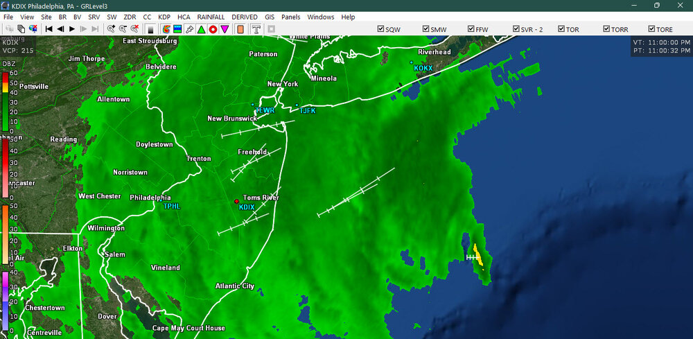
-
Yes the night they dropped to 39 was on my birthday =/ I'm still upset with that although it did warm up into the 70s here that day with clear blue skies and I saw two bald eagles that day. My low was 39.6. Some interesting years in that list. Both 1933 and 2002 are on the highest minimums list but both had historic winters. Meanwhile our TV mets keep insisting that the only months above normal this year were March and April. It's just the overnight low so no big deal. If the highs were in the mid 80s that would be a big deal. I wish this noreaster had waited until late October, thats a more appropriate time for it. Plus it can snow then. I uploaded the images to social media and then resaved them onto my phone it's the only way I know how to resize them on my phone I'll post more here . She slept in that flower bed overnight and woke up around noon wagged her tail at me and sauntered off. A late sleeper lol. Thanks Chris. Yes it's probably pretty close to MPO and Lake Harmony those other places are much lower in elevation. Temperatures seem to match too. Nearest moderate sized town with an airport is Lehighton 9.6 miles away but much lower in elevation. In July they hit 101 on back to back days just like Allentown did but I was around 93-94 similar to Mount Pocono although I'm halfway between Mount Pocono and Allentown. My more southerly location at high elevation is an advantage during strong el ninos this area got 30 inches during the January 2016 blockbuster in which both Allentown and JFK got over 30 inches. I-80 was the cut off point for the higher totals. Do you have a chart for local coops that measured snow during January 2016 maybe even Lake Harmony Chris? Thanks! PS I was mapping elevation on my property using an app called Gaia GPS. It's very useful it showed me two areas on my property where rain water pools because the elevation there is slightly less. According to the USGS maps I looked at the front of my property is around 1525 feet and the back is around 1535 feet but some smoothing must be involved . There are two markers on their maps one shows an elevation of 1507 feet right by the lake and another shows 1542 feet a ways behind my property. But my property has several dips and rises. GAIA GPS told me the elevation near my front door is the highest on the property at around 1575 feet while it's only 1505 feet at the bottom of my driveway near the wooden gate. I know for sure that my entire property is over 1500 feet though because the lake level itself is at 1495 feet.
-
 https://canamcrosscare.com/# canadian pharmacies online
 -

Central PA Autumn 2026
TheDreamTraveler replied to canderson's topic in Upstate New York/Pennsylvania
Here's a great post from the Atlantic Hurricane Season thread about the current nor'easter. Post is 19 hours old now but still. Oh another thing too the center of the storm had convection firing around the center and some lightning earlier. Very interesting. -
Low of 52, high of 78. Chilly this morning.
-

Strong Nor'Easter/Hybrid Storm Late September 2026
LibertyBell replied to Rjay's topic in New York City Metro
51 mph gust at MPO elevation trumps coastal location. Almost an inch here. It's not been too bad though as the rain has been spread out over a long time. That 51mph gust surprised me though. -
Went to the Maryland football game today. It's time to fire Locksley. His "give me one more year to rebuild" has failed. Though Maryland was stupid in negotiating his contract and his buyout is nearly $10m. Can't afford to keep him, can't afford to fire him.
-

Strong Nor'Easter/Hybrid Storm Late September 2026
nycsnow replied to Rjay's topic in New York City Metro
Winds def increasing and you can hear that distinct roar with some of the gust -
.09 in Leesburg
-

October Comes Early: Late September Multi-Hazard Hybrid Storm
mreaves replied to WxWatcher007's topic in New England
I have an 8:20 tee time so I hope it holds. -

Strong Nor'Easter/Hybrid Storm Late September 2026
FPizz replied to Rjay's topic in New York City Metro
.55" so far. Highest gust 31. -

October Comes Early: Late September Multi-Hazard Hybrid Storm
HIPPYVALLEY replied to WxWatcher007's topic in New England
Congrats to everybody on the coast though, I bet it’s pretty fun observations on the beaches. I think Montauk Point or Block Island would’ve been the place to chase this one. - Today
-
The band that rotated down started during half-time. After UCLA scored 2 touchdowns in top of the 3rd quarter, the whole stadium emptied out. Those that were sadistic enough to stay took up the seats underneath the overhangs. I stayed until 3rd quarter 10 min when the lead went to 30+ by UCLA.