All Activity
- Past hour
-
Next winter is going to suck.
-
I mean this is a very classic ice storm look for SNE, south of pike.
-
Let’s get a March 24, 1993 mini blue bomb at Logan (over 8” of pure spackle on a weak but juicy system running into a Quebec high with marginal antecedent airmass)
-
Definitely starting to notice the slow uptick in temps.
-
0z NAM continues to strengthen the push of the BDCF. If it’s right, cold sector hangs on from Thursday evening thorough Saturday evening from NoVA north and east. Front looks like gets as far SW as Lynchburg.
-
Lol I’ve seen others post similar, but I wanted to make sure each direction was covered. I might have to add that my elevation is too low to escape a warm nose haha.
-
Isothermal sounding on this NAM over Logan. NE wind 30mph pushing S/S+ rates is nasty cake at 32
-
This looks like a signiicant icing event south of pike with potential all the way down to 95. Needless to say, glad I’m largely missing this one to the north…
-
For Boston... 00z 12k NAM coming in with 6-8" 00z 3k NAM says, what snow? 00z HRRR says 4-6" 18z GFS says 4-6" 18z EURO says 4-6"
-
Ha! So excited to see it all go over the next week. Was a good winter but glad it’s pretty much over!
-
I wouldn’t get too hung up on models generating convection, and then using that as QPF distribution Thing is that these general isenreopic event types are better handled by the coarser smoothed solutions. The meth models are going to spuriously trigger convection that is completely driven by chaos in the model and then that’s gonna turn around and fuck up all the works
-
For those thinking this weather is a bit early. Wait about 10 more days and things will definitely correct course.
-
3k not nearly as good as 12k. Handling of the convection upstream seems to be jumping around.
-
NAM arrives at the party
-
Let’s get play dough
-
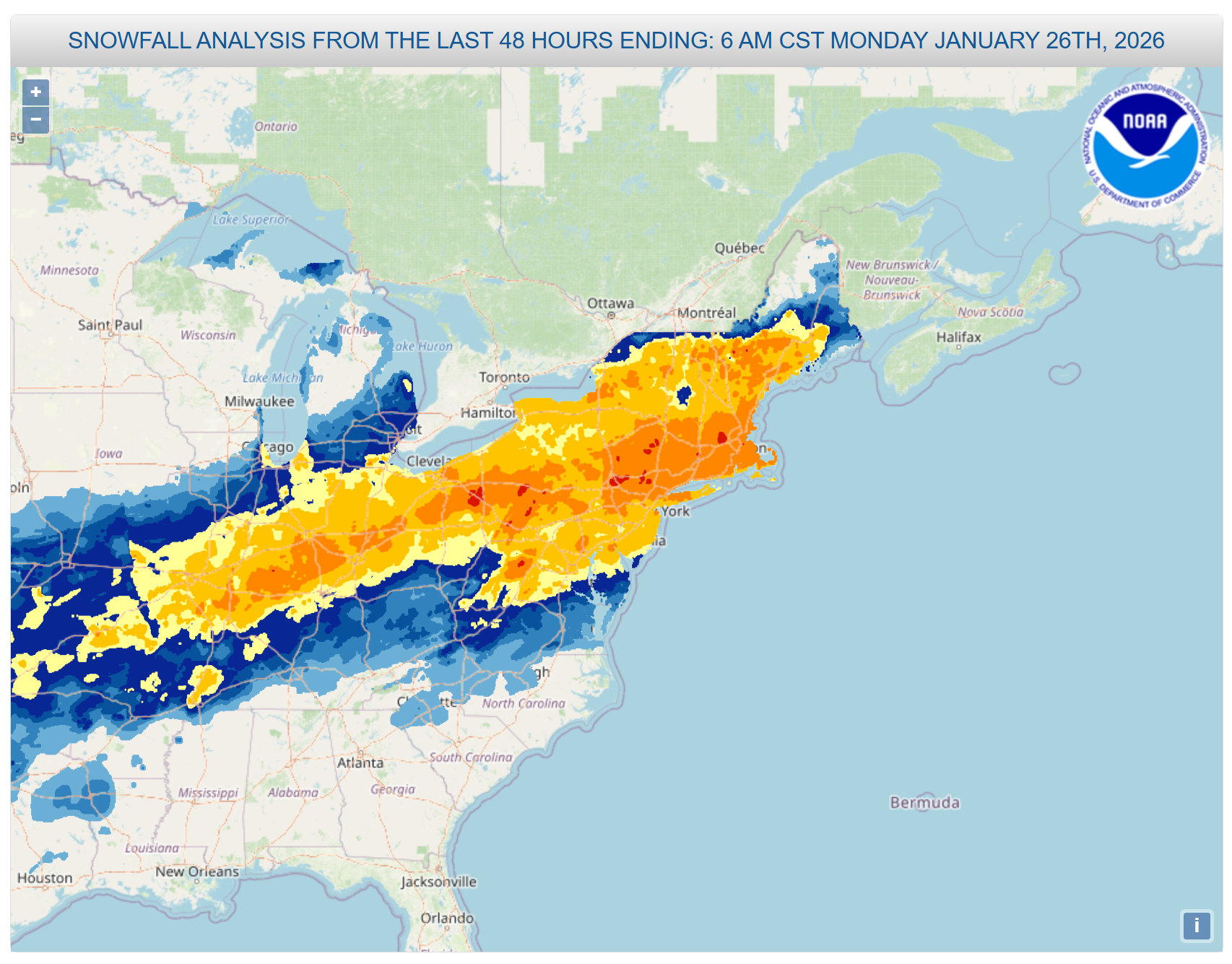
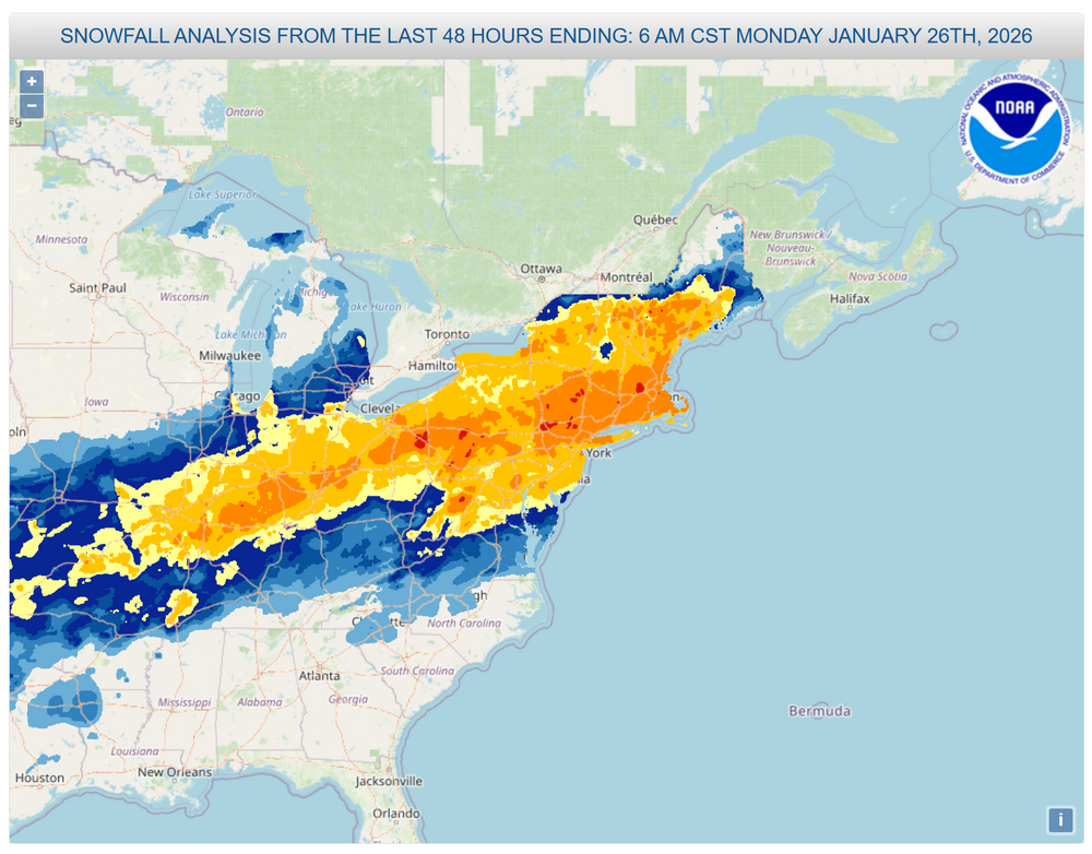
I'd still like to know when, if ever, Jan 25-26th is coming. There are some pretty puny Cat 1s in that list so i have no doubt its obviously higher than a Cat 1. Has to be at least 2 or 3. I dont know if theyll ever do it, if they skipped right over to Feb Thats a large area of 8-18 over major US cities
-
Nam going wild
-
00z HRRR says Boston sees moderate snow accumulations...not buying that at the moment. Severe gradient just to the south, little to nothing down at the Braintree split.
-
HRRR has SEMass (Plymouth and Bristol counties) radiating more than anyone tonight. Soundings for 11Z show 20˚ at the surface and 50˚ juuuust above the surface. Cranberry bog special. TAN and MVY already down to 30˚, OWD at 32˚. Cranberry bog special!
-
This is going to be one of those years where the trees are still bare on April Fool’s Day isn’t it?
-
Dry weather will be short-lived. Additional rain will arrive tomorrow and continue into Friday. A general 0.50"-1.50" rainfall is likely. Highs will likely reach the lower 40s tomorrow and Friday. It will turn noticeably warmer during the weekend. Long Island and coastal sections could be noticeably cooler than interior sections on a number of days on account of a chilly onshore flow. The ENSO Region 1+2 anomaly was +1.0°C and the Region 3.4 anomaly was -0.1°C for the week centered around February 25. For the past six weeks, the ENSO Region 1+2 anomaly has averaged +0.62°C and the ENSO Region 3.4 anomaly has averaged -0.28°C. Neutral ENSO conditions have now developed. Neutral ENSO conditions will continue through at least mid-spring. The SOI was +19.53 today. The preliminary Arctic Oscillation (AO) was +1.240 today.
-
That’s a lot of models to be on crack…just saying.
-
That would be a no. Watched lightning go from W/NW to N to N/NE as storm skirted JUST to the north. Still got enough sprinkles to get everything wet.
-
You got it! I think of the Mid-South starting with the MEM CWA, then add West Kentucky. Might some add to the halfway point of KY/TN. Sometimes for chasing I'll fudge it to northwest Alabama. Vague boundaries help hedge forecasts, to be honest haha. Note that all of Mississippi and all of all of Alabama are considered Deep South too. East Tennessee into northeast Alabama I'll often refer to as the Tennessee Valley. Of course the River goes on downstream curling north into the Ohio River, but at that point I'm talking Mid-South. Speaking of all this.. Mid-month cold could start Mid-South. However it should eventually have a little longer stay in the Valley. Keep in mind cold in March is nothing like cold in Feb. Shouldn't be too bad. At the same time, Mountains could get late season snow showers a couple times. Moderator / Admin: Feel free to move this and/or copy to one of the resources threads.
- 10 replies
-
- 1
-

-
- severe
- mountain snow
- (and 1 more)
-
Welcome to Seattle