All Activity
- Past hour
-

Southern MD / Lower Eastern Shore weather discussion
SnowtoRain replied to PrinceFrederickWx's topic in Mid Atlantic
Freezing drizzle now. -

December 2025 Short/Medium Range Forecast Thread
Carvers Gap replied to John1122's topic in Tennessee Valley
Agree. As noted by a poster in another forum(maybe ENSO on the main page), this is a pattern which is often hard to break down, i.e. cold over the Hudson Bay, a small ridge over the Southwest, and kind of a flat, stable trough in the East. That Alaska feed into the SE is a classic old-school pattern. I know we've talked about it before. It seems like modeling has shown this in the past only for it not to verify. This time it is in place. That is a cold, cold feed at times. -

Richmond Metro/Hampton Roads Area Discussion
migratingwx replied to RIC Airport's topic in Mid Atlantic
18z GFS hot off the press also suggest to keep an eye out on Monday.
-
Awesome! Let's hope for a big winter... we need one after the last few.
-
So you want to play a game? .
-

December 2025 Short/Medium Range Forecast Thread
Daniel Boone replied to John1122's topic in Tennessee Valley
I do wish we had a bit more cold in Place. If a Lee side develops that won't be a problem. In 95-96 we had snow producing waves akin to last night but with well established Cold in place. We had several Miller B to Miller A Transfer's . Couple of those were big Dogs that went on to be powerful Noreasters. There were a couple decent Clippers as well. I will say, imo we're on track to have a great Winter Snow wise . The Cuban heat HP that had the deep SE flooded with very warm Temps and aided the mild upper Layers of our area to be as mild as they have has weakened and shifted SE. -
-
December 2025 Short/Medium Range Forecast Thread
Carvers Gap replied to John1122's topic in Tennessee Valley
I kind of see this more as a system where NE TN folks(SW VA) see the snow hang on just a hair longer w/ NW flow to follow. It isn't a big NW flow event, but it is present on all short range models, especially for the Plateau. -
I like the cut of your jib. My last and only experience with a norlun was Jan 2011. Let’s go for a repeat of that month!
-
Yep. Been a while since we've had a snow fall and accumulate on everything and STAY. Usually we end up with 20-30 mph winds after and it all gets blown out/off.
-
December 2025 Short/Medium Range Forecast Thread
Carvers Gap replied to John1122's topic in Tennessee Valley
This is probably a more favorable trend for our folks in North Carolina, but you can see the various iterations of precip backing. -
Richmond Metro/Hampton Roads Area Discussion
migratingwx replied to RIC Airport's topic in Mid Atlantic
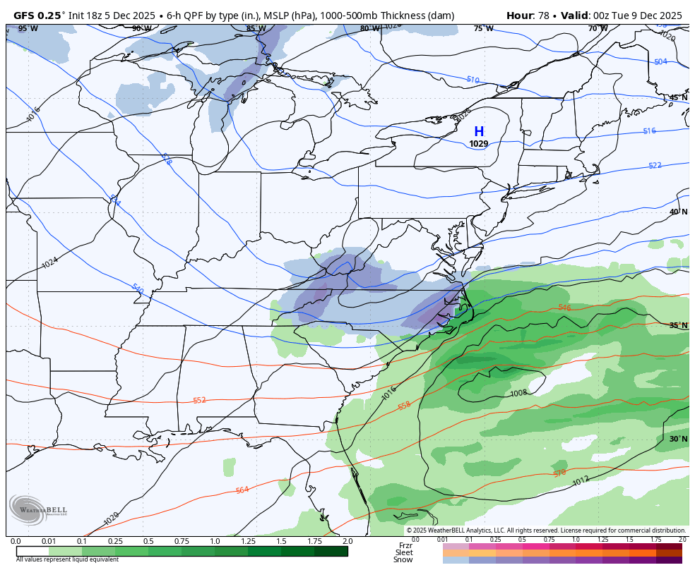
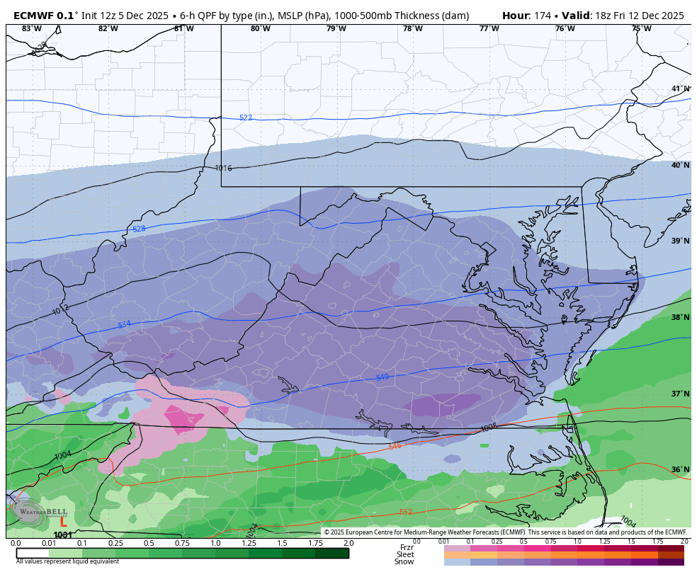
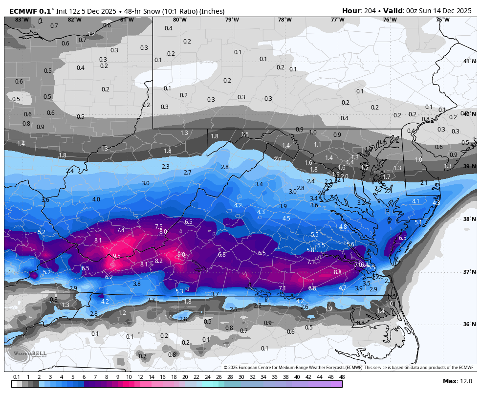
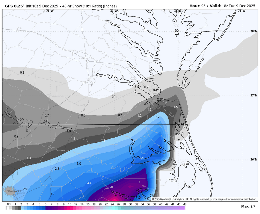
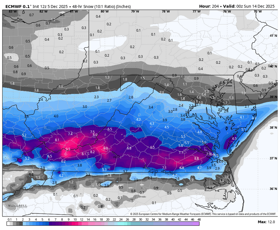
Hey, this is me, just under a different name. I wish I had that sort of power, but there was some discussion years ago to use a nearby COOP station "for" the airport, but it had to be within 5 miles of the airport. The Varina COOP station was being used for some reports, such as the 12/9/2018 storm, but last I checked, that station had closed down, and they were looking for another nearby observer. I'm not sure what is happening now. I don't mind chiming in here from time to time. I'm glad I was able to share some snow and cold. We had a big snow here last Saturday, so I've been posting in the forum covering this area. 2.0" on 12/5 is a good start for the winter, and RIC is long overdue for a 20"+ season, so maybe this is it? There are two more threats for you all that need to be watched for Monday and possibly next Friday. Below ICON for the possible Monday event and then today's 12z Euro showing next Friday's threat.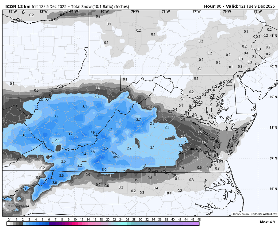

-
Track away.
-
Can’t remember the last time I even thought to use “Sasketchewan Screamer” or “Manitoba Mauler” in my vocabulary. Potential shot after shot next couple weeks.
-
Two edged sword. It beats down what snow you have on the ground, BUT it has a lot of staying power and is there long after the snow is gone.
-
Beyond picturesque outside. Trees just caked in cement. Like a real life snow globe.
-
Let’s play a game of find the lee .
-
 Sound good. I may be able to croak @butterfish55 and @TauntonBlizzard2013to make brief appearances, barring schedule conflicts.
 -
GEFS with quite the increase in precip as well. I still think thermals would be an issue, especially that time of day.
-

The Friday Storm 12/5/2025
WinstonSalemArlington replied to Coach McGuirk's topic in Southeastern States
-
December 2025 regional war/obs/disco thread
Baroclinic Zone replied to Torch Tiger's topic in New England
Workable for sure at this time period. Flow as currently modeled is relatively flat with not much ridging in PNA. Euro seems a bit more amplified with this. Something to watch. Until than not much going on. Catch some FROPA and and maybe a Clippah. -
December 2025 Short/Medium Range Forecast Thread
Carvers Gap replied to John1122's topic in Tennessee Valley
I really thought there would be zero support for the 18z GFS solution w/ ensemble members, but there are a decent number which have similarity. There were almost none of those at 12z. -
The new HRRR and RAP on Pivotal are showing 0.1 and 0.2 of snow respectively and no freezing rain in the metro overnight. HRDPS isn’t showing anything and neither is the RRFS
-

December 2025 regional war/obs/disco thread
SouthCoastMA replied to Torch Tiger's topic in New England
GFS has something on 12th, near benchmark. Weak, but workable 7 days out -
Light snow and snizzle currently. I was out taking pictures of the snowy Christmas decorations and noticed it was lightly snowing.