All Activity
- Past hour
-
I’m at T-minus 3 hours until Indian Restaurant and some Taj Mahal.
-
Would think NWS will need to post high wind watches tomorrow for the area. That 969 LP is characteristic of a high end CAT 1 OR low end CAT 2.
-
Nice! I can see something like this happening if the lows tuck west and throws the ccb further west into nova/81. Let’s see if 18z/0z models start showing this
-
The Blizzard Warnings were expanded significantly inland along eastern PA, NJ and a good ways up the Hudson in an arc around RI and Mass. My wife is living temporarily in NYC on the upper West Side and taking Amtrak back tonight to avoid what will likely be a shutdown of Amtrak in the NW corridor tomorrow. Tempting to go with her to see NYC get nailed from her 23rd floor view. Had a nice snow in Dec that was awesome to watch from an elevated perch.
-
Almost all of NJ except NW border counties under a Blizzard Warning...not sure I have seen that so expansive before...
-
You are too young to drink but not to young to get Nam'd
-
More subsidence than dry slot. .
-

2/22-23 "There's no way..." Storm Part 2
RickinBaltimore replied to Maestrobjwa's topic in Mid Atlantic
Just a hunch on my part, but I have a feeling we are going to be pleasantly surprised by this storm. -
@CAPE got his blizzard warning lol
-
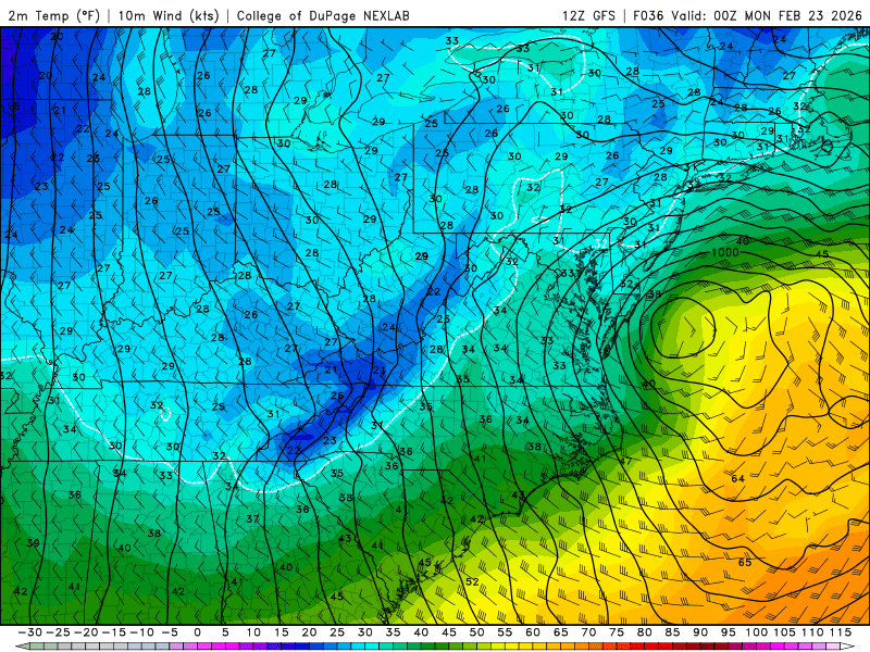
On the 12z GFS surface temps for our area dip to 33-34 degrees under heavy rates. The storm is generating its own cold air by dragging down colder air aloft. It is the issue, as we really don’t have a true cold air source, so high bust potential if you take snow maps literal. It all comes down to where banding sets up or heavy rates occur.
-
Pure gold. Thanks man.
-

Central PA Winter 25/26 Discussion and Obs
Blizzard of 93 replied to MAG5035's topic in Upstate New York/Pennsylvania
This is what I’ve been talking about that CTP mentioned in our Warning ADDITIONAL DETAILS...Uncertainty remains for where the heaviest snow bands will occur. Snow totals could be higher depending on these localized bands. Snowfall at times could exceed 1 inch per hour rates. -
Well, I will let you know. I am about 7 miles north of 84 leaning more towards eastern Dutchess. I bought a plow for my quad before winter, definitely came in handy this year. More fun than snow blowing. .
-
Just got text alert from Bobby Martrich @ EPAWA. For my area. Snow begins between 8-10 am. Heaviest overnight. Blizzard conditions possible. Accumulation 12-18". Locally higher.
-

“Cory’s in NYC! Let’s HECS!” Feb. 22-24 Disco
Ginx snewx replied to TheSnowman's topic in New England
Running it this afternoon -
Latest SREF is juiced. 10"+ from DC northeast.
-

2025-2026 Fall/Winter Mountain Thread
nchighcountrywx replied to Buckethead's topic in Southeastern States

-
“Cory’s in NYC! Let’s HECS!” Feb. 22-24 Disco
Ginx snewx replied to TheSnowman's topic in New England
Dude pool burst out. Lost the liner. 28 inches of ice. Good thing I saw the leak and was able to slowly release it. -

2/22-23 "There's no way..." Storm Part 2
DDweatherman replied to Maestrobjwa's topic in Mid Atlantic
If the euro makes one more improvement at h5 like 6z did from 0z and then subsequently at 12z again, you won’t have to worry pal. -
Central PA Winter 25/26 Discussion and Obs
Blizzard of 93 replied to MAG5035's topic in Upstate New York/Pennsylvania
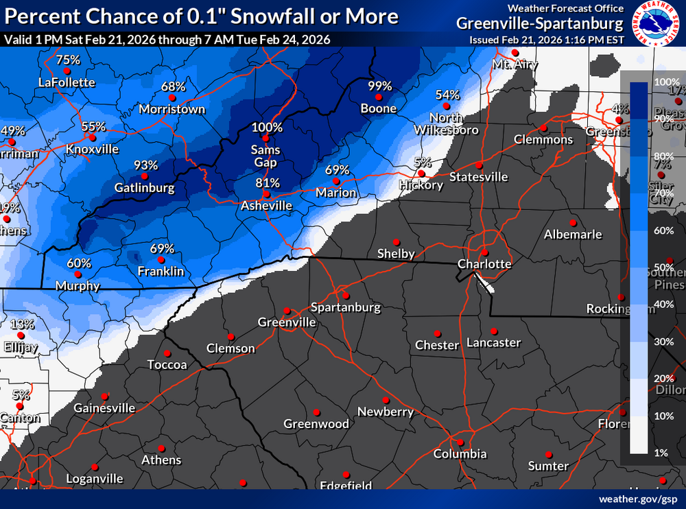
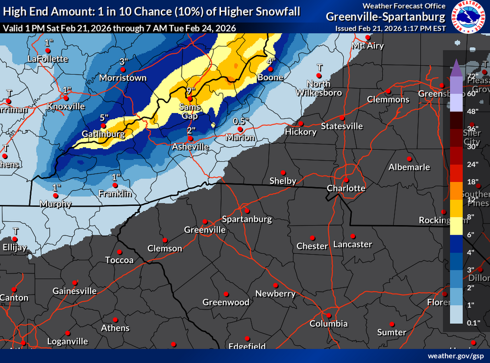
Winter Storm Warning URGENT - WINTER WEATHER MESSAGE National Weather Service State College PA 143 PM EST Sat Feb 21 2026 ...IMPACTFUL WINTER STORM TO BRING HEAVY SNOWFALL TO CENTRAL PENNSYLVANIA... PAZ057>059-064>066-221130- /O.UPG.KCTP.WS.A.0004.260222T1000Z-260223T1800Z/ /O.NEW.KCTP.WS.W.0002.260222T1000Z-260223T1800Z/ Dauphin-Schuylkill-Lebanon-Adams-York-Lancaster- Including the cities of Hershey, York, Pottsville, Lancaster, Lebanon, Gettysburg, and Harrisburg 143 PM EST Sat Feb 21 2026 ...WINTER STORM WARNING IN EFFECT FROM 5 AM SUNDAY TO 1 PM EST MONDAY... * WHAT...Heavy snow likely. Total snow accumulations between 6 and 12 inches possible. Winds could gust as high as 40 mph Sunday night and Monday. * WHERE...A portion of central Pennsylvania. * WHEN...From 5 AM Sunday to 1 PM EST Monday. * IMPACTS...The strong winds and weight of snow on tree limbs may down power lines and could cause sporadic power outages. Travel could be very difficult to impossible. The hazardous conditions could impact the Monday morning commute. * ADDITIONAL DETAILS...Uncertainty remains for where the heaviest snow bands will occur. Snow totals could be higher depending on these localized bands. Snowfall at times could exceed 1 inch per hour rates. PRECAUTIONARY/PREPAREDNESS ACTIONS... Persons are urged to stay indoors until conditions improve. If you must go outside, dress in layers. Several layers of clothes will keep you warmer than a single heavy coat. Cover exposed skin to reduce your risk of frostbite or hypothermia. Gloves, a scarf, and a hat will keep you from losing your body heat. Persons should consider delaying all travel. Motorists should use extreme caution if travel is absolutely necessary -
Why no 15z Srefs snowfall map? Don't mind if I do.
.thumb.png.b70ad9eaa561cd030b99eb2dc8dc92aa.png)
-
NWS upgraded my blizzard warning to 9-12"
-

2/22-23 "There's no way..." Storm Part 2
SomeguyfromTakomaPark replied to Maestrobjwa's topic in Mid Atlantic
Yeah that’s wild. -

“Cory’s in NYC! Let’s HECS!” Feb. 22-24 Disco
ScituateMA replied to TheSnowman's topic in New England
Hope everyone near the coast has their generator prepped and gas ready to go. I dont see how we could get through this without power outages -
Holy shit, wow ...I am speechless


.png.222de638b6e7a0406773a5de76dcc56f.png)


