All Activity
- Past hour
-

July 2025 Obs/Disco ... possible historic month for heat
moneypitmike replied to Typhoon Tip's topic in New England
Perfect coc day today. -

July 2025 Obs/Disco ... possible historic month for heat
kdxken replied to Typhoon Tip's topic in New England
Heatwave looks doable in spots at the end of the week. -

2025-2026 ENSO
40/70 Benchmark replied to 40/70 Benchmark's topic in Weather Forecasting and Discussion
Its not going to be an official La Nina, but that doesn't matter...agree otherwise. -
2025-2026 ENSO
40/70 Benchmark replied to 40/70 Benchmark's topic in Weather Forecasting and Discussion
I think its still going to be a pretty costly season due to a late home-brew barrage. -
2025-2026 ENSO
40/70 Benchmark replied to 40/70 Benchmark's topic in Weather Forecasting and Discussion
I kind of get some 2007-2008 vibes for the coming winter.... -

2025-2026 ENSO
PhiEaglesfan712 replied to 40/70 Benchmark's topic in Weather Forecasting and Discussion
Yeah, even without the blocking, we still had one final hurrah during the final third of March. 2011-03-23 40 32 36.0 -8.8 29 0 0.87 T 0 2011-03-24 44 30 37.0 -8.2 28 0 0.09 1.0 1 2011-03-25 42 28 35.0 -10.5 30 0 0.00 0.0 0 2011-03-26 40 26 33.0 -12.9 32 0 0.00 0.0 0 2011-03-27 45 28 36.5 -9.7 28 0 0.00 0.0 0 2011-03-28 45 26 35.5 -11.1 29 0 0.00 0.0 0 2011-03-29 49 31 40.0 -6.9 25 0 0.00 0.0 0 2011-03-30 53 36 44.5 -2.8 20 0 0.01 0.0 0 2011-03-31 43 37 40.0 -7.7 25 0 0.13 T 0 This turned a solid warm first two-thirds of the month into a negative departure. - Today
-
July 2025 Obs/Disco ... possible historic month for heat
kdxken replied to Typhoon Tip's topic in New England
-

July 2025 Obs/Disco ... possible historic month for heat
HoarfrostHubb replied to Typhoon Tip's topic in New England
What? What? I can’t hear you! Def a good porter. They need to sell snacks though. -

July 2025 Obs/Disco ... possible historic month for heat
Damage In Tolland replied to Typhoon Tip's topic in New England
Poor ACATT -
DP still in the low 70s. Should be Friday/Saturday until we see that again.
-
Indeed. And I definitely agree with you that there is going to be a real strong tendency for -PNA this winter given the 2nd year -ENSO. Very extensive research supports this
-

July 2025 Obs/Disco ... possible historic month for heat
dendrite replied to Typhoon Tip's topic in New England
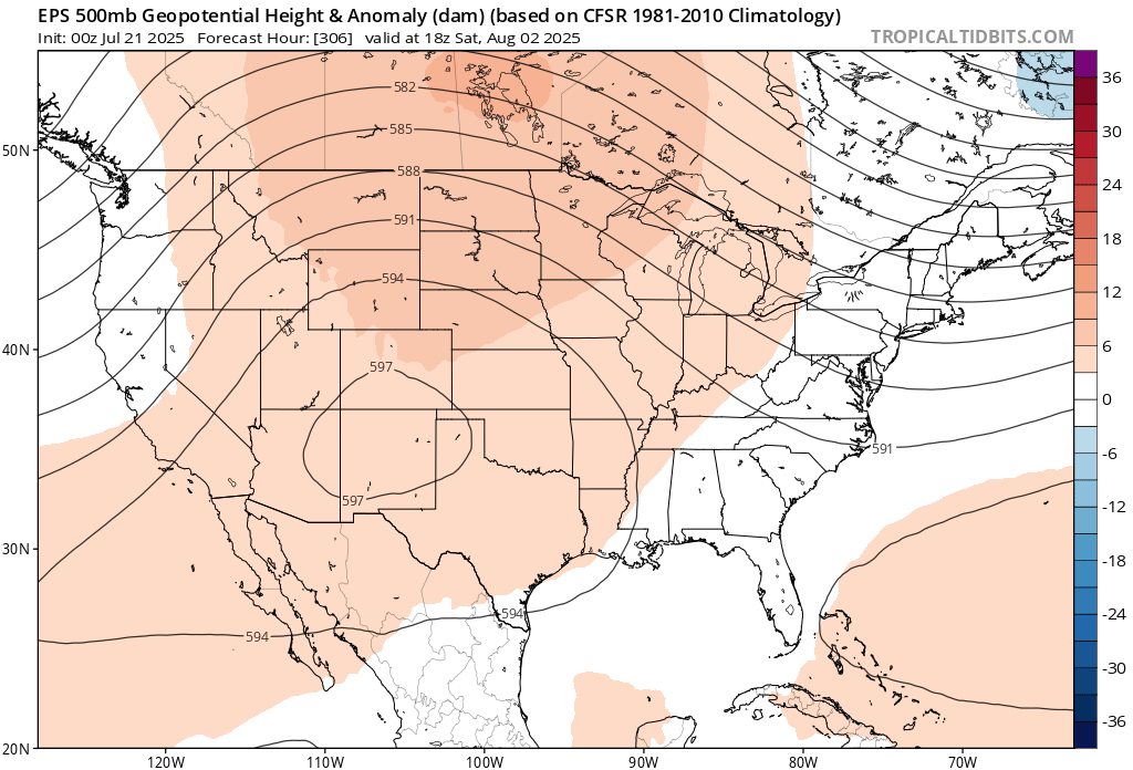
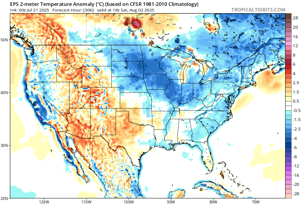
The maps are trash…especially the 2m 18z anomaly ones. Yeah…it’s going to be that cold in the upper midwest with this look.
-
IMO we are all lined up to see a well below average Atlantic hurricane season in both named storms and ACE
-

July 2025 Obs/Disco ... possible historic month for heat
Torch Tiger replied to Typhoon Tip's topic in New England
what am I looking for -
I have no doubt that if the blocking didn’t break down in February, NYC would have seen more snow that winter than the 95-96 winter and probably by a lot
-

2025 Atlantic Hurricane Season
LongBeachSurfFreak replied to BarryStantonGBP's topic in Tropical Headquarters
Pretty much mirrors the sea surface temp profile from earlier. Having the subtropics warmer then the tropics destroys vertical instability in the MDR. The reason they think the season is weighted towards the second half is climatological. Seasonally the subtropics will begin to cool faster then the tropics and return a more normal instability profile. Last year should have been a wake up call. Warmer water doesn’t automatically mean a hyperactive season. -

July 2025 Obs/Disco ... possible historic month for heat
ineedsnow replied to Typhoon Tip's topic in New England
We take!
-
-
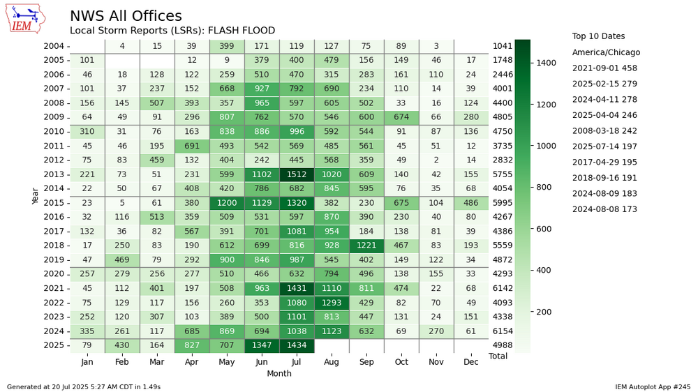
Good comment. Below are flash flood local storm reports (LSR) in the same format. Can only go back to 2004. With reports there may also be non-weather/climate factors that change with time. In any case, this year on a record pace, with February, April and June setting monthly records and July also on a record setting pace.
-

2025 Atlantic Hurricane Season
Boston Bulldog replied to BarryStantonGBP's topic in Tropical Headquarters
My confidence is steadily growing that Barry Stanton GBP is CurlyHeadedBarrett’s (last year’s bizarre spammer) new account. The frequent abbreviations and copy-pasting of content from elsewhere as a form of bastardized “analysis” is uncanny. The first 3 posts in the entire thread are an excellent microcosm. Regardless, it makes the thread nearly unreadable. On topics that matter, still nothing of note for the Atlantic for a while -
Crazy to think that if that blocking stuck around even for another week NYC would have been in reach for the snowiest winter in recorded history. That Chicago blizzard would have probably done it
-

July 2025 Discussion-OBS - seasonable summer variability
dmillz25 replied to wdrag's topic in New York City Metro
91 for the high here yesterday -
July 2025 Obs/Disco ... possible historic month for heat
ineedsnow replied to Typhoon Tip's topic in New England
we 40s again tonight Monday Mostly sunny, with a high near 73. Northwest wind 9 to 15 mph. Monday Night Clear, with a low around 47. North wind around 6 mph becoming calm in the evening. Tuesday Sunny, with a high near 76. Calm wind becoming northwest around 5 mph in the afternoon. Tuesday Night Mostly clear, with a low around 51. Calm wind. Wednesday Sunny, with a high near 82. Calm wind becoming southwest around 6 mph in the afternoon -

2025-2026 ENSO
Stormchaserchuck1 replied to 40/70 Benchmark's topic in Weather Forecasting and Discussion
You might say that these are not big anomalies, but this is the +AO that just won't go away. So persistent since May! There might really be the chance for some -EPO periods this Winter, as I believe a cold H5 over the Greenland part of the Arctic Circle correlates to -epo/+pna actually in the wintertime.. not sure I would forecast anything other than a negative PNA though with what's going on in the Pacific. We saw this same pattern last year until September. -
Picked up about .4 today, about 2 inches the last week. Areas just west of me in Scott Co has gotten around 6+ inches of rain the last few days.