All Activity
- Past hour
-
At 78 compared to 06z, looks like we have better confluence out front. Phase looks maybe a tad more disjointed, Baja low now getting pulled up in front of the NS protrusion to the NW as much? Overall not a huge change but not gonna get amped to death past 84 I think…
-

January 2026 regional war/obs/disco thread
Typhoon Tip replied to Baroclinic Zone's topic in New England
I mean god! it's so frustrating dude. I typically wish stage 3 reproductive cancer on anyone but this motherfucker is trying my patience - -
The main difference in the models overnight was the piece of energy over Alberta. It is acting as a kicker, scooping out the baha low and phasing in behind it. This allows the SLP to gain some latitude and get into the interior southeast before transferring offshore (This will happen due to the cold air physics). Pretty much a classic Miller B vs the more Miller A setup we were seeing 24 hours ago. For a snow scenario in the south, you ideally want that PV lob to be stronger and sitting over New York, vs southern Canada. This will bring more WAA aloft (aka more ZR/IP). It could also setup a screw zone in the area around/outside the CAD pocket. (Or non-screw zone if you like have heat/power). NC IMBY -- Since this will be a 48 hour event, the hope for snow in NC, per my thinking yesterday, is we get a wave of WAA snow/overrunning so far out ahead of the main SLP. This would allow for some snow before the WAA aloft kicks in as the SLP draws near. Otherwise this will be sleet/ZR fest for the favored areas.
-
Rgem has better position of the hp. Almost moves east in tandem with the slp flowering right below. More cold press east of the OV.
-
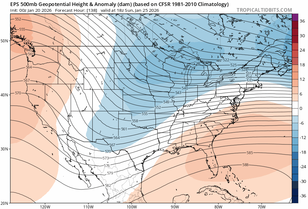
12z RGEM h5 and precipitation at 84
-

January 2026 Medium/Long Range Discussion
North Balti Zen replied to snowfan's topic in Mid Atlantic
Is this where I can extrapolate the NAM for February 2? -
lol this place is never happy
-

January 2026 regional war/obs/disco thread
jbenedet replied to Baroclinic Zone's topic in New England
The resolving of long wave features that the EPS and GEFS typically can reliably provide inside 10 days was absent. That was the rug pull. In just 6 runs inside 6 days the EPS is looking completely different in synoptic evolution.
-

January 2026 regional war/obs/disco thread
RUNNAWAYICEBERG replied to Baroclinic Zone's topic in New England
We can send @Masswxto do the job but unfortunately his dad told him the pattern ahead is not good, cold and dry, so he is working on his spring training swing already… -

Central PA Winter 25/26 Discussion and Obs
AccuChris replied to MAG5035's topic in Upstate New York/Pennsylvania
Remember it very well too! Hi Res NAM 48 hours out started spitting out stupid numbers for Lebanon ranging from 27”-35” at times leading up to it. Measured 32” when it was over . -
Beautifully worded and my thoughts as well lol. I actually rather have a clean 6 incher than a 12 incher with pounding annoying sleet all day.
-

Possible Record Breaking Cold + Snow Sunday 1/25 - Tuesday 1/27
mriceyman replied to TriPol's topic in New York City Metro
Forky in the house.. game on . -
motherofsidewaysfucks, are people really extrapolating the NAM and then worrying about their fictional extrapolation?
-
12z RGEM at range. It will often give us clues for the upcoming GEM run. For posterity and the eventual forensics investigation into this...If I hadn't seen 0z last night, I would say is that is going to be a severe ice storm if that low kicks out late or a snowstorm if it goes with that 1050 high. Usually, 1050 highs are money for frozen in this forum. However, there is definite precedent for it to rain behind big highs like that, but still is crazy to watch.
-

Central PA Winter 25/26 Discussion and Obs
pasnownut replied to MAG5035's topic in Upstate New York/Pennsylvania
Next up - its the Germans to keep hope alive. -
Rgem has more separation out west wrt the baja ull and the ns trying to phase in. A little slower to move out too? May be a less amped outcome.
-
Hard to tell early but looks little less phased and little more confluence over the top.
-

Occasional Thoughts on Climate Change
TheClimateChanger replied to donsutherland1's topic in Climate Change
Maybe I'm wrong to call it "rigged" but it just so happens that this incontrovertible fact favors the spin that the original poster wanted. And Grok even cited climate as an example, I didn't even bring it up in my query. All I'm saying is that explains a significant portion of why records - both highs and lows - tail off later in the dataset. Of course, lows are dropping more rapidly than highs because the mean is not constant, but rather is slowly rising. -
Central PA Winter 25/26 Discussion and Obs
pasnownut replied to MAG5035's topic in Upstate New York/Pennsylvania
yep that was NAM's vs the rest if memory served. Coup scored. -

January 2026 regional war/obs/disco thread
40/70 Benchmark replied to Baroclinic Zone's topic in New England
Elegantly obtuse -

January 25-26 Winter Storm Potential
Lucy Pull replied to Ralph Wiggum's topic in Philadelphia Region
Definitely looks to be amped, potentially more than 6z euro depending on stream interaction. Long range nam though but not far from euro structurally. -
But what if it ends as sleet? It would be ruined!
-
Freaking bingo!
-
Extrapolated NAM would be an overturned semi hauling Grape Nutz in my yard lol. Had a feeling yesterday morning that in the end a sleet bomb would be more likely than a top 10 snow event. Odds increasing every suite lol.
-
Occasional Thoughts on Climate Change
TheClimateChanger replied to donsutherland1's topic in Climate Change
I just knew someone would call me out for simply stated an incontrovertible fact. Run a random number generator with a certain degree of random variability around a, more or less, constant mean. If you credit the record (i.e., highest and lowest value) only to the first occurrence, more "records" will occur early in the dataset. This is simple mathematics/statistics - no tricks.