All Activity
- Past hour
-
Just impossible to put any faith in the models anymore.
-
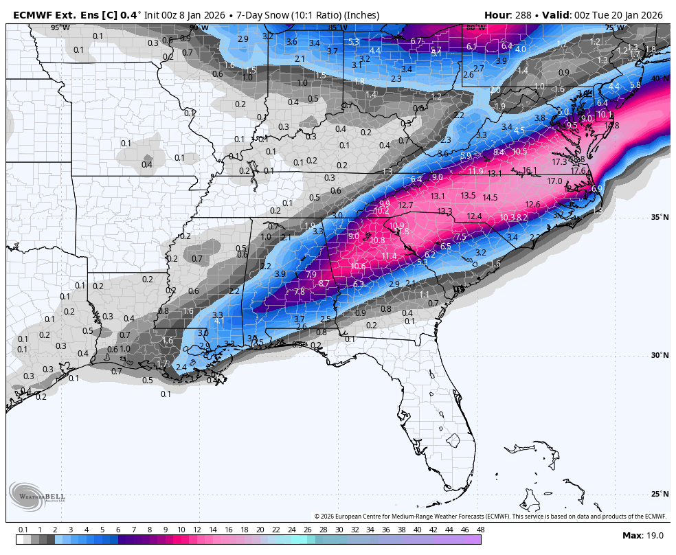
Obviously this is a far stretch but it shows the potential if everything goes right.
-

January 2026 regional war/obs/disco thread
ORH_wxman replied to Baroclinic Zone's topic in New England
A little bit of Wilton on that look late in the game (after maybe a few shots at a coastal in the D10-13 range)....some people might get a little scared of the orange colors at H5 getting close to NE, but that is a frigid northern tier look with that WPO/AO domain look.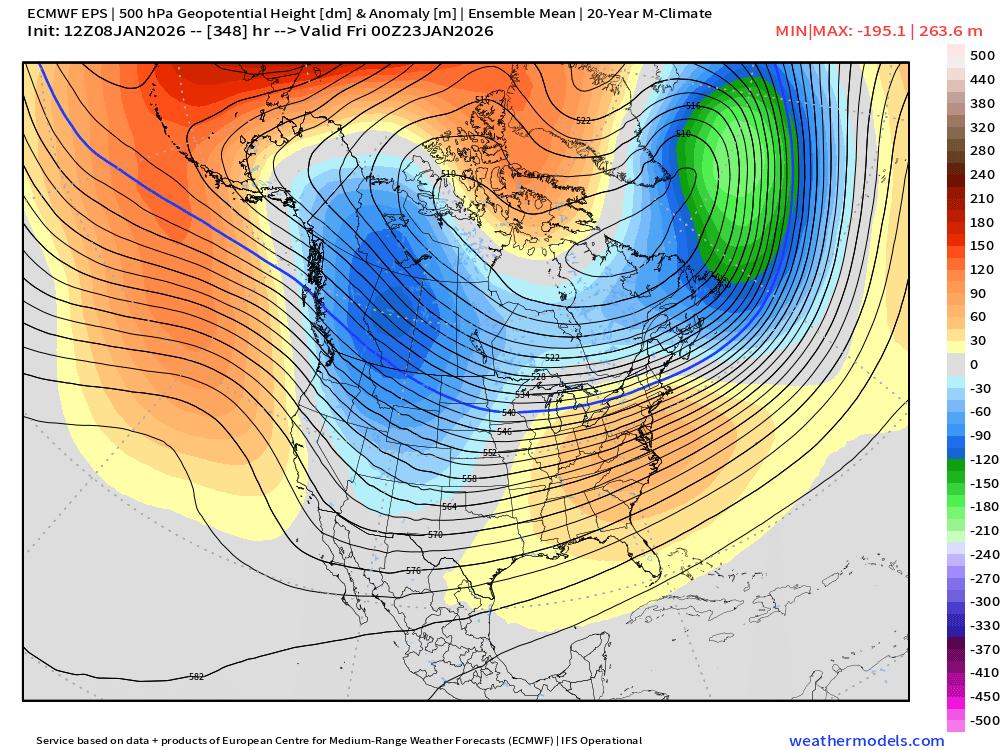
-
So what's everyone's thoughts about the next 10 days? Looks like we have some decent chances coming up.
-

Mid-Long Range Discussion 2026
gamecockinupstateSC replied to BooneWX's topic in Southeastern States
Well, we got a weenie run. Euro Wkly Control.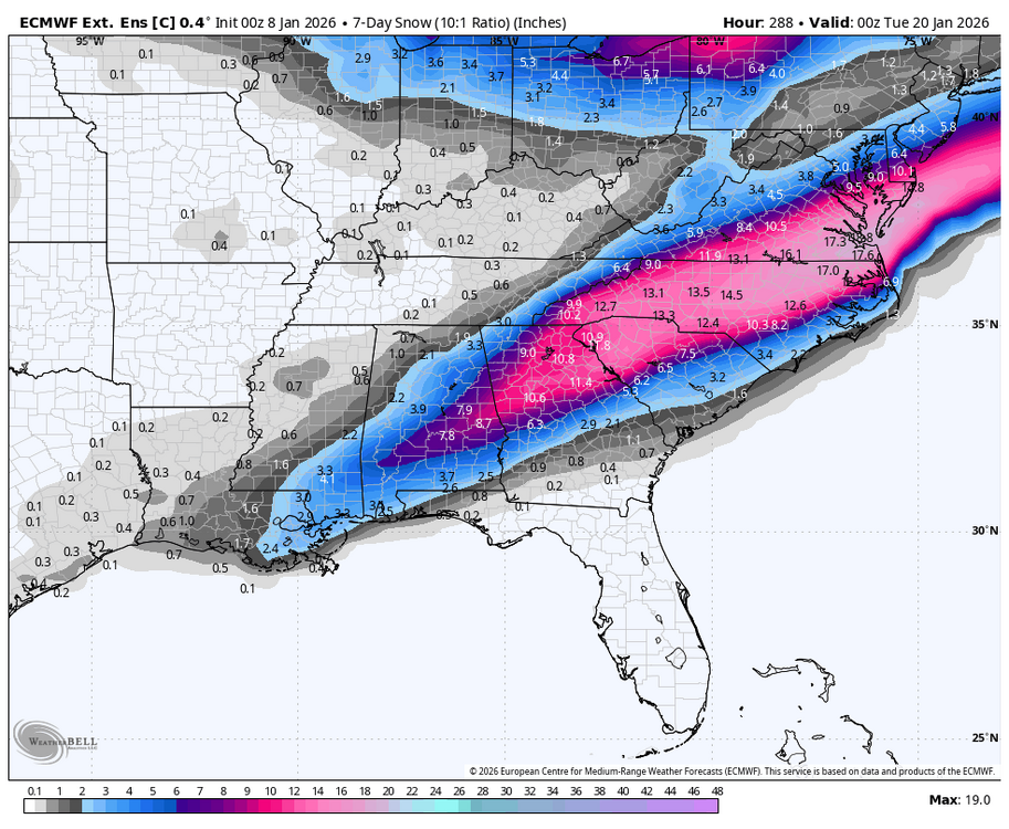
-
In a year framed largely by persistent drought, it was perhaps a flash flood that provided one of the most memorable and impactful events of the year. I realize we pay less attention to what happens outside of the beltways and the space in between, but Westernport sits almost at the base of backbone mountain and the N Branch Potomac river, uniquely vulnerable to a flash flood as evidenced in May 2025. https://www.wbaltv.com/article/150-students-evacuated-boats-allegany-county-school/64760668 Honorable mention: Deep Creek cabin experienced subzero low temperatures on 4 consecutive nights in January, the longest string of subzero lows at this location for at least the previous 4 years.
-

January 2026 regional war/obs/disco thread
CoastalWx replied to Baroclinic Zone's topic in New England
Lips and hips played on your blue tooth speaker while you shovel? -
January 2026 regional war/obs/disco thread
ORH_wxman replied to Baroclinic Zone's topic in New England
Honestly, I think a way CC can help is you'll get these mega juiced systems when the longwave pattern lines up correctly....you'll have some season where it goes bonkers (ala 2015 in E MA)....all the extra moisture just getting freight-trained into New England with a cold dome overhead. -

January 2026 regional war/obs/disco thread
Go Kart Mozart replied to Baroclinic Zone's topic in New England
This will be a good weekend for shoveling the accumulated dogshit in the back yard. Three dogs and two weeks of snow cover. It will be a lot! -
This is still in the long range . A few more days .
-
51 off a low of 27. Felt nice!
-
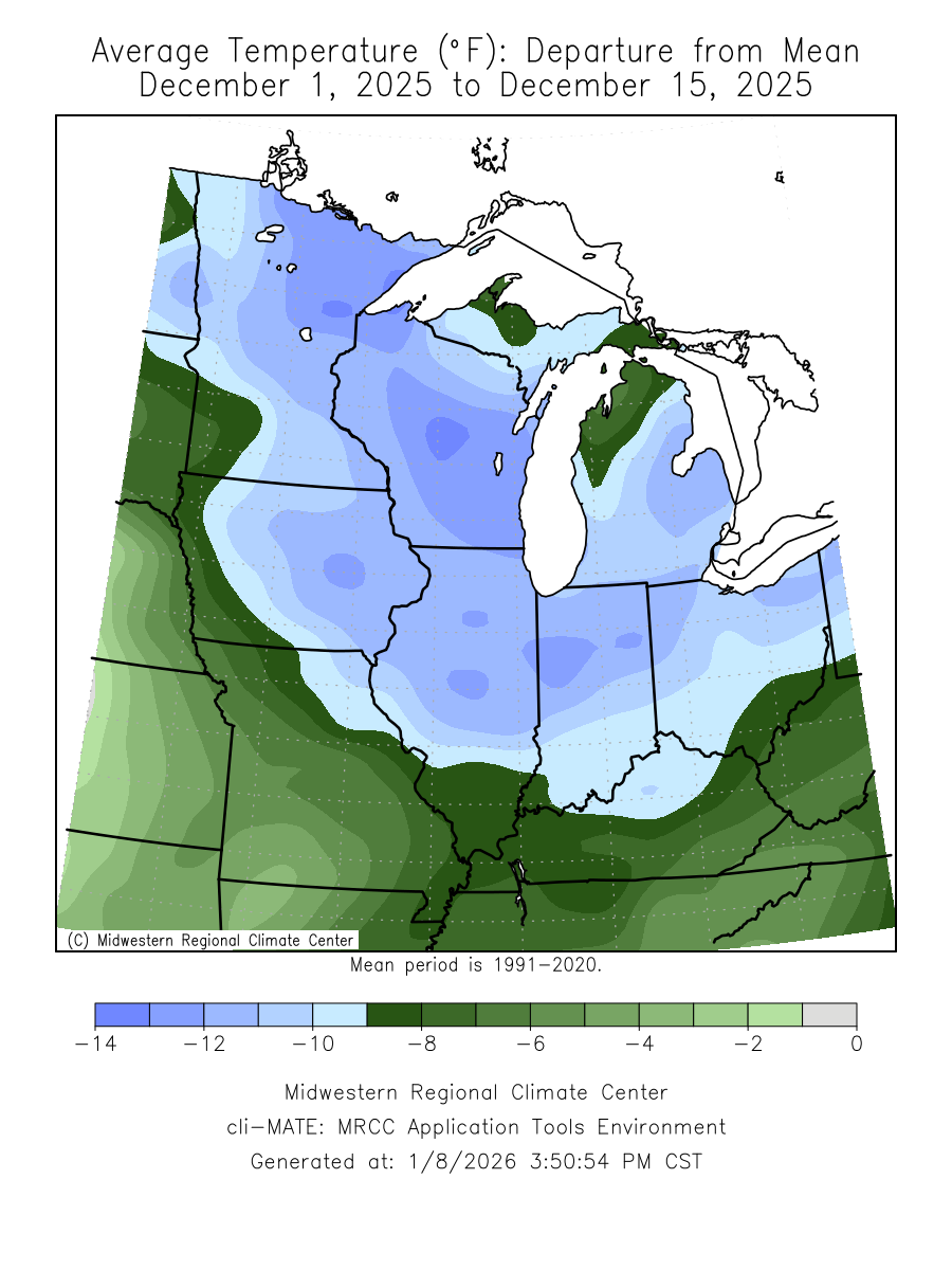
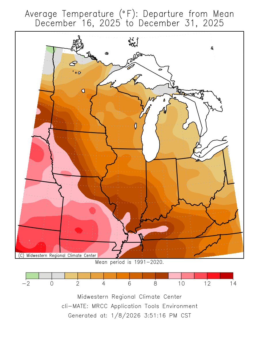
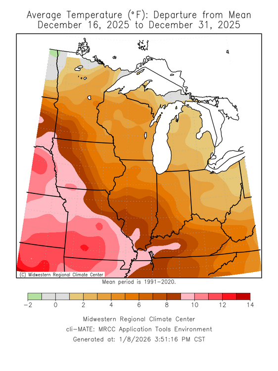
Dec was impressive both ways this year. From CC cringe To CC orgasm

-
i sent him $500 for 2 hiking passes for this weeknd and still haven't heard back and getting a little worried
-
January 2026 regional war/obs/disco thread
CoastalWx replied to Baroclinic Zone's topic in New England
That’s basically me looking at the last 4 years of snow data. -
January 2026 regional war/obs/disco thread
CoastalWx replied to Baroclinic Zone's topic in New England
Looking at the extended on the EPS you normally would think that offers something. -
(002).thumb.png.6e3d9d46bca5fe41aab7a74871dd8af8.png)
E PA/NJ/DE Winter 2025-26 Obs/Discussion
ChescoWx replied to LVblizzard's topic in Philadelphia Region
valley spots around me were in the 20's but mid 30's here -

January 2026 regional war/obs/disco thread
Ginx snewx replied to Baroclinic Zone's topic in New England
Everytime I read your sad posts it makes me think of this. https://www.facebook.com/share/r/17wRUvSMGK/ -
Sir, this is a Wendy’s
-

January 2026 regional war/obs/disco thread
dryslot replied to Baroclinic Zone's topic in New England
We take, Tonight Patchy freezing fog after 10pm. Partly cloudy, with a low around 15. Calm wind. Friday A 30 percent chance of rain after 4pm. Patchy freezing fog before 10am. Mostly cloudy, with a high near 40. Light south wind increasing to 5 to 10 mph in the afternoon. Winds could gust as high as 25 mph. New precipitation amounts of less than a tenth of an inch possible. Friday Night Rain, mainly before midnight. Low around 33. South wind around 10 mph becoming west after midnight. Winds could gust as high as 20 mph. Chance of precipitation is 80%. New precipitation amounts of less than a tenth of an inch possible. Saturday Increasing clouds, with a high near 42. West wind around 5 mph becoming calm in the afternoon. Saturday Night Snow, mainly after 9pm. Low around 27. Calm wind becoming northeast around 5 mph. Chance of precipitation is 80%. New snow accumulation of 1 to 3 inches possible. Sunday Snow likely, mainly before 9am. Cloudy, with a high near 34. Chance of precipitation is 60%. Sunday Night A 40 percent chance of snow before 1am. Mostly cloudy, with a low around 21. Monday Mostly sunny, with a high near 30. Monday Night Mostly cloudy, with a low around 19. -

2025-2026 ENSO
PhiEaglesfan712 replied to 40/70 Benchmark's topic in Weather Forecasting and Discussion
MEI just updated. ND 2025 came in at -0.8 -

Mountain West Discussion
mayjawintastawm replied to mayjawintastawm's topic in Central/Western States
Pretty soon we’ll be driving ourselves crazy looking at models that predict yesterdays snowstorm that never happened. -

E PA/NJ/DE Winter 2025-26 Obs/Discussion
Birds~69 replied to LVblizzard's topic in Philadelphia Region
I didn't even notice, I thought we did. -
E PA/NJ/DE Winter 2025-26 Obs/Discussion
Birds~69 replied to LVblizzard's topic in Philadelphia Region
Yeah, you're right, same. I thought we just made 32F but apparently not. -
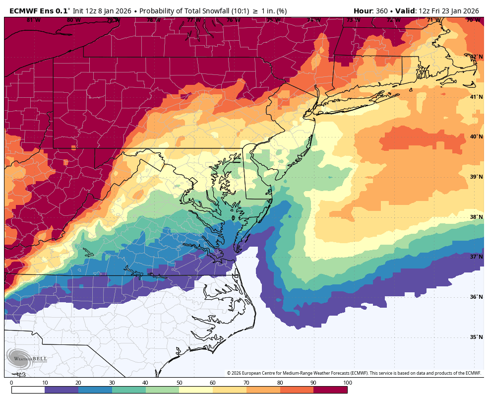
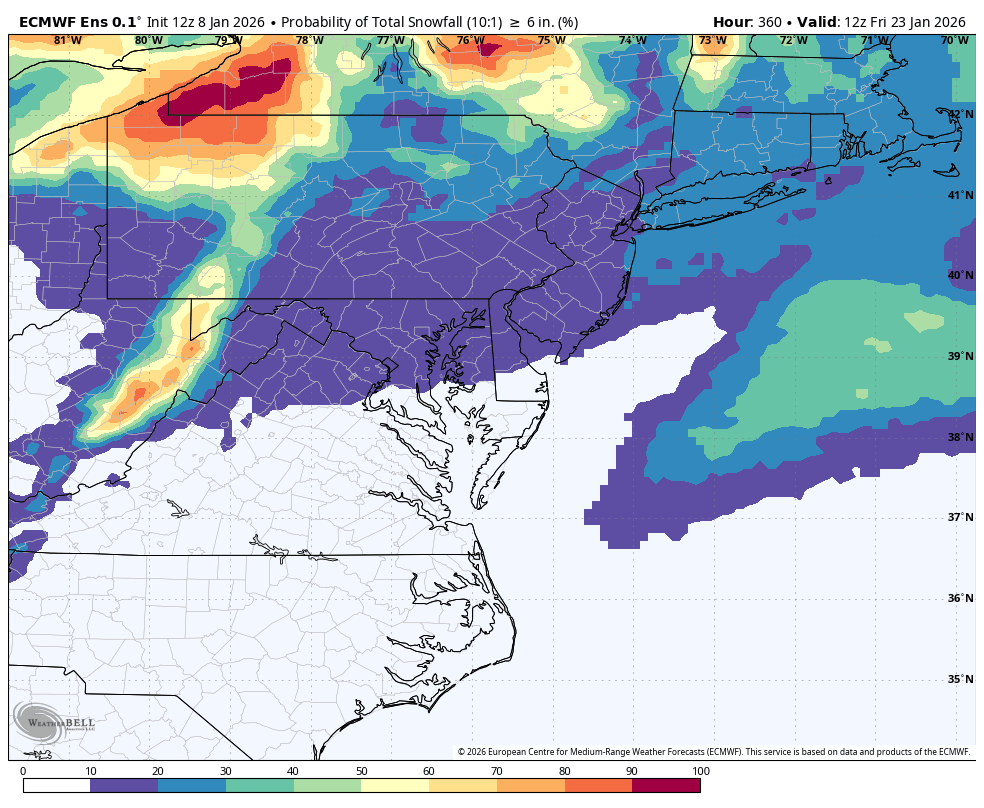
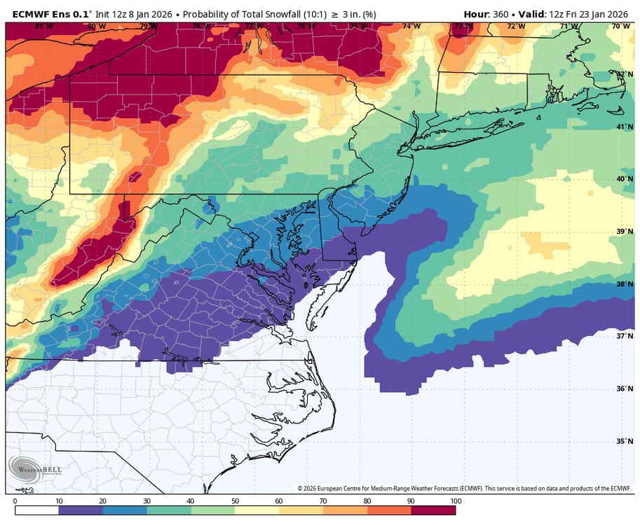
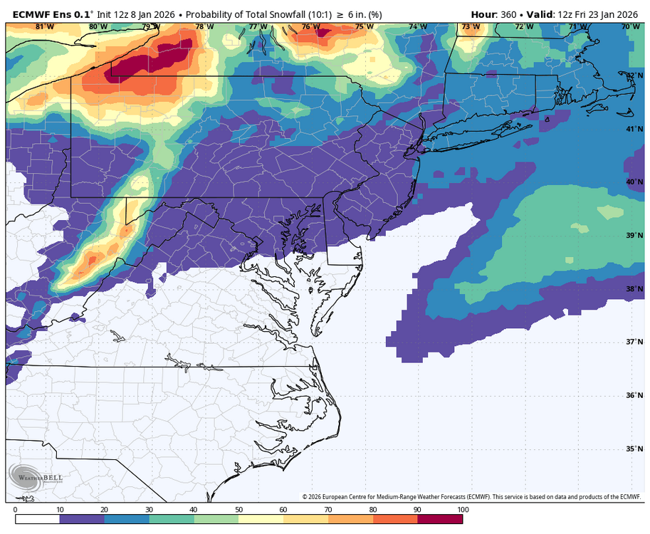
WB 12Z EPS probs ( all Day 7 onward) .... 1, 3, and 6 inches.

-

2025-2026 ENSO
40/70 Benchmark replied to 40/70 Benchmark's topic in Weather Forecasting and Discussion
Agree with above, but def very modest departures.