All Activity
- Past hour
-
 legitimate online pharmacy or best online pharmacy no prescription no rx needed pharmacy https://www.google.com.cu/url?q=https://medguideusa.com medstore online pharmacy and http://bbs.51pinzhi.cn/home.php?mod=space&uid=8265121 online pharmacy without prescription [url=https://cse.google.com.ph/url?q=https://medguideusa.com]best rx pharmacy online[/url] medicine online or [url=http://lostfilmhd.com/user/kmweffbyrk/]legal online pharmacies in the us[/url] shop medicine online
 -
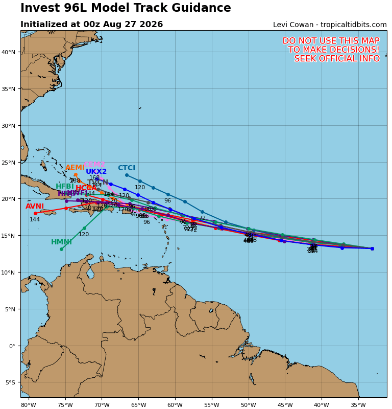
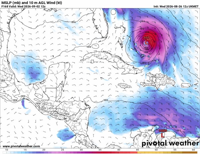
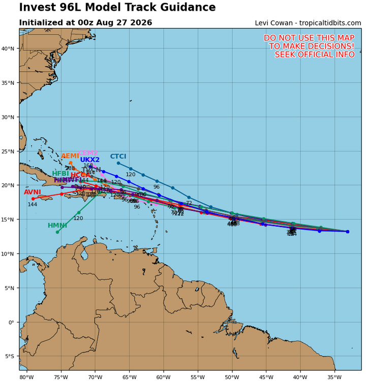
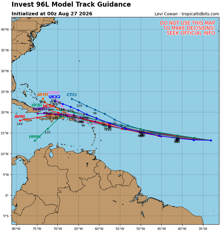
Not only did that preceding low appear on the 0Z UK, it is actually classified a TD on the 0Z at hour 108 in the subtropics and a TS at hour 132 on a WSW track ending not too far offshore E coast of FL on the way to a hit there on Sept 3rd as it is trapped by a strong SE H5 high: NEW TROPICAL CYCLONE FORECAST TO DEVELOP AFTER 108 HOURS FORECAST POSITION AT T+108 : 29.9N 72.3W LEAD CENTRAL MAXIMUM WIND VERIFYING TIME TIME POSITION PRESSURE (MB) SPEED (KNOTS) -------------- ---- -------- ------------- ------------- 1200UTC 31.08.2026 108 29.9N 72.3W 1014 25 0000UTC 01.09.2026 120 29.4N 72.3W 1011 30 1200UTC 01.09.2026 132 28.9N 72.4W 1007 35 0000UTC 02.09.2026 144 28.0N 73.7W 1005 37 1200UTC 02.09.2026 156 27.3N 75.6W 1005 38 0000UTC 03.09.2026 168 26.8N 77.3W 1003 37 Meanwhile, 96L is initialized as a TD, which is consistent with its 12Z run. Again, it remains a TD moving rapidly WNW in the MDR with a skimming of the N Leewards. It then becomes a TS but then it misses the SE Bahamas as it turns NW and NNW due to Fujihara around the preceding TS: TROPICAL CYCLONE DEVELOPED IN THE MODEL ANALYSIS AT POSITION : 14.1N 33.5W LEAD CENTRAL MAXIMUM WIND VERIFYING TIME TIME POSITION PRESSURE (MB) SPEED (KNOTS) -------------- ---- -------- ------------- ------------- 0000UTC 27.08.2026 0 14.1N 33.5W 1011 29 1200UTC 27.08.2026 12 13.8N 37.1W 1010 29 0000UTC 28.08.2026 24 14.2N 41.5W 1010 29 1200UTC 28.08.2026 36 14.4N 46.4W 1011 31 0000UTC 29.08.2026 48 15.1N 50.8W 1011 29 1200UTC 29.08.2026 60 16.0N 54.9W 1012 32 0000UTC 30.08.2026 72 16.8N 58.5W 1012 30 1200UTC 30.08.2026 84 18.2N 61.9W 1012 32 0000UTC 31.08.2026 96 19.3N 64.9W 1011 30 1200UTC 31.08.2026 108 20.8N 67.1W 1011 31 0000UTC 01.09.2026 120 21.9N 68.8W 1011 29 1200UTC 01.09.2026 132 22.5N 70.0W 1009 30 0000UTC 02.09.2026 144 23.6N 70.4W 1007 32 1200UTC 02.09.2026 156 25.5N 70.9W 1007 36 0000UTC 03.09.2026 168 27.2N 71.6W 1008 37 @WxWatcher007 Complications like this fascinate me as they make the forecasting much more difficult, which makes for more interesting forecast discussions.
-
Check this out: MedGuide USA. Good luck!
- Today
-
On the cusp...guidance all over the place
-
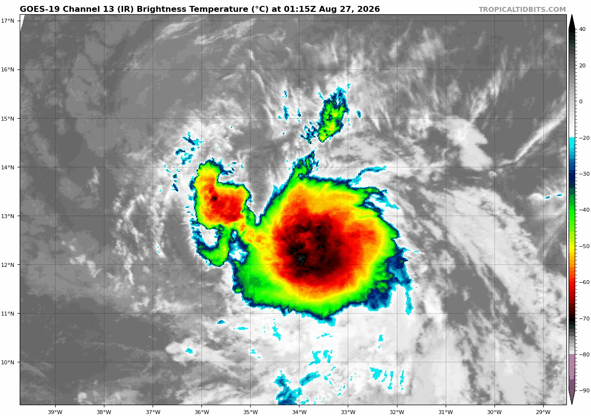
It's a thread the needle type deal because too far of a trend and it'll get ripped apart by the Antilles/Cuba. Long way to go though...guidance all over the place. Tropical Weather Outlook NWS National Hurricane Center Miami FL 200 AM EDT Thu Aug 27 2026 For the North Atlantic...Caribbean Sea and the Gulf of America: 1. Eastern Tropical Atlantic (AL96): Satellite imagery indicate that showers and thunderstorms associated with an area of low pressure, located several hundred miles west-southwest of the Cabo Verde Islands, have become better organized tonight. If the current trends continue, advisories could be initiated on a short-lived tropical depression or storm later today. However, environmental conditions are expected to become hostile beginning on Friday, likely ending its chances for development. * Formation chance through 48 hours...high...70 percent. * Formation chance through 7 days...high...70 percent. Forecaster Adams
-

2026 Atlantic Hurricane Season
WxWatcher007 replied to Stormchaserchuck1's topic in Tropical Headquarters
The only caution flag is that we've had several seasons recently where the Atlantic was dead in August, only to come to life in September and October. Now, my forecast contemplates that and doesn't foresee some sort of structural change that makes the basin more favorable, but I highly doubt we end up with nothing. -
For more information, visit https://www.medguideusa.shop/ - MedGuideUSA - it helped me a lot.
-
83/67 for a nice summer day. That rain helped the dews today.
-
 Wow, you forecasted a -PNA in 23-24. Congrats on that, I think that's a really good forecast. PNA region ended up having an anomaly of +45dm for DJFM
 -
We haven't had a +PNA month in 7 months. Recent winters have skewed very ridgey in the N. Pacific relative to ENSO. I mean I don't think this winter will have a la nina pattern but I would definitely not expect a N. Pacific vortex like 97-98, 82-83, 15-16 in the mean.
-

2026 Mid-Atlantic Severe Storm General Discussion
high risk replied to Kmlwx's topic in Mid Atlantic
I don't hate the Thursday severe setup. Parameters are not high-end for sure, but there is probably enough instability and shear to justify the SLGT risk. CAMs prefer areas to the east and northeast of DC. Several have an idea of initial storms in northeast MD backbuilding through the Baltimore area and eventually into Howard/PG/AA Counties before sinking south towards Charles/Calvert/St Marys. It's an odd evolution, but given that it shows up in multiple evening CAMs, I can't discount it. -
We track?
-
Keeps shifting west
-
It's located on the running trail that goes behind the baseball fields. Feel free to stop by.
-
The big heat for next week has always been a question mark due to the possibility of onshore flow. Models backed off, but it's still a close call on whether we'll get the heat or it stays to the south and west.
-

Augdewst 2026: Summer's Last Stand
Brewbeer replied to Prismshine Productions's topic in New England
folks interested in looking at the definitive data for New England electricity generation and transmission definitely should check out the ISO New England website @Laymanlinked above, the data are nearly endless and highly informative https://www.iso-ne.com/isoexpress/ it's worth noting that the 7-day capacity forecast includes temperature and dew point forecasts for both Boston and Hartford. one of the most fascinating graphs from ISO NE is how much and how quickly the 5 minute locational marginal price for a MWH changes -
Heat has backed off for late august/early september timeframe. Forky in shambles.
-

Augdewst 2026: Summer's Last Stand
vortex95 replied to Prismshine Productions's topic in New England
Yes, what does the state *import*. They seem to have left that out. But never let such facts interfere w/ a desired narrative or virtue signaling. "but you can call yourself green because it's a larger share --- and then import the lion's share of your electric from a non-green heavy grid." The fine art of cherry-picking and playing w/ numbers! -
Augdewst 2026: Summer's Last Stand
vortex95 replied to Prismshine Productions's topic in New England
Of course. Right, there are about 50 magnitude 4-5 quakes every day. So how does that work? Did CC "target" Nepal for some reason? The Himalayan chain is very prone to quakes due to the Indian Plate collision. And this was only a moderate quake. Law of averages and large numbers say something like this is going to happen from time to time, a concept the MSM and many grifters ignore or lack. So did the AK Lituya Bay quake and landslide megatsunmai in 1958, what caused that? The idea that sfc temp changes cause quakes anything more that frostquakes is ridiculous. Quakes original far down often in superheated or molten areas. And regardless of CC, the topmost layer going down 10s of ft experience massive thermal stress year round unevenly around the globe w/ the change of seasons, and not just from temp, but rain/snow/ice as well. The Moon's pull alone "works over" the Earth's crust constantly, and likely triggers many smaller of the quakes we see every day, along w/ tides, so there is no sensitivity tipping point or whatever! -
Check this out: MedGuide USA. Good luck!
-
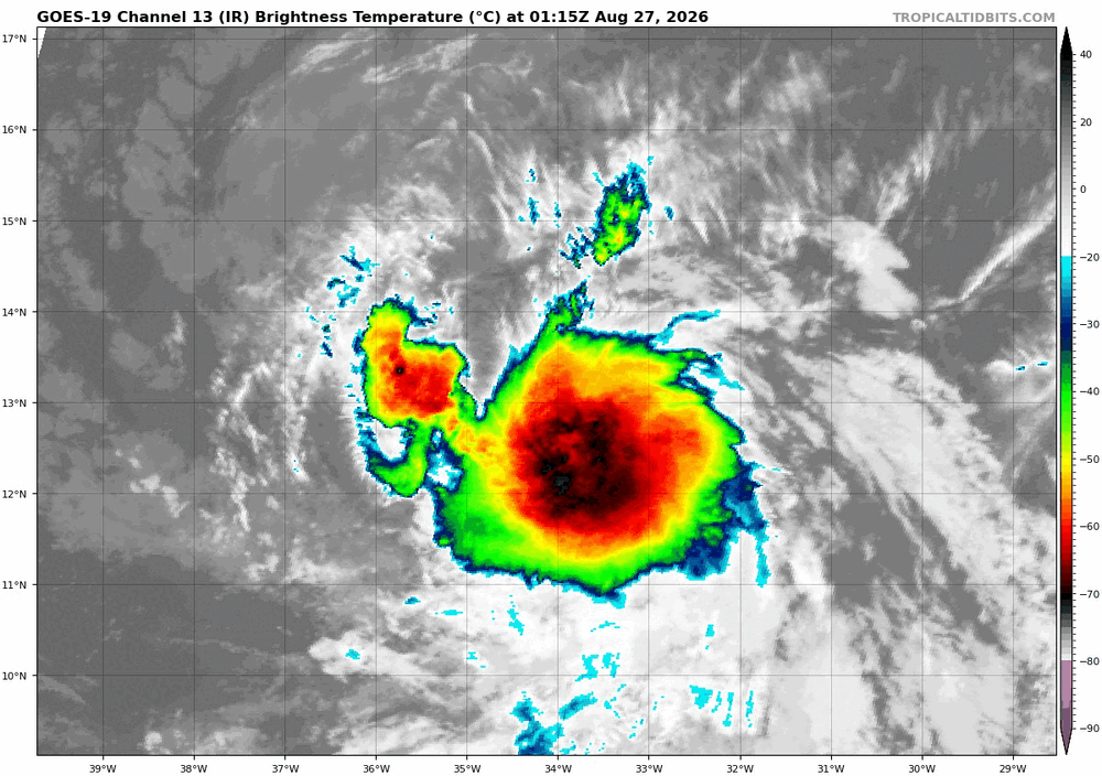
Agreed. If it can hold the convection overnight and still looks like this on first visible pictures we should have a least a TD by tomorrow 5am....maybe even a TS if we get a good ASCAT pass over the next 6-10 hours. Winds were marginal TS earlier but circulation was not completely closed off, no west wind. This satellite pic looks healthy. Thinking along the lines of TD or TS next 2-3 days then weakening beyond that and perhaps if it can hold together enough some regeneration north of the islands or east of the Bahamas down the road. Most guidance has shifted south and west last few days indicative of a weaker system I believe.
-

2026 Atlantic Hurricane Season
PhiEaglesfan712 replied to Stormchaserchuck1's topic in Tropical Headquarters
Funny thing is that wouldn't be true because 13 years ago was 2013, which was a very quiet season. All storms that year were either TS or C1. All of the notable hurricanes came during the active seasons of 2010, 2011, and 2012, which were 14-16 years ago. -

2026-2027 Record-breaking El Nino
40/70 Benchmark replied to Stormchaserchuck1's topic in Weather Forecasting and Discussion
Index Value Predicted '23-'24 DM Value Range Actual '23-'24 DM Value Forecast Error Pacific Decadal Oscillation (PDO) -.30 to -.60 -1.51 Biased .91 positive Perennial North American Pattern (PNA) -.35 to -.65 +.55 Biased .90 negative ENSO OND 1.7-1.9 ONI EMI: .6 - .8 (West Tilt Basin-Wide) NDJ 2.0 EMI: .30 .01 degree too cool and one month too early. Biased .30 West (J-M) East Pacific Oscillation (EPO) +.30 to +.60 -.04 Biased .34 positive Arctic Oscillation (AO) -.30 to -.60 -.10 Biased .20 negative North Atlantic Oscillation (NAO) +.10 to -.20 +.76 Biased .66 negative -
All of a sudden looks like TS Dolly...
-
More details can be found at [url=https://medguideusa.com/guide/zithromax/]MedGuideUSA[/url]. Good luck!