All Activity
- Past hour
-

September 2025 OBS-Discussion centered NYC subforum
MJO812 replied to wdrag's topic in New York City Metro
59 here -
Everything is wagons north
-
This looks closer to 3" this week.
-
What started a few days ago as a 4-5 day 1.5"-2" soaker has already shrunk to a 3 day 0.75" event with as much soaking power as the Steelers. Soon I fear it will move to Bengal soaking levels. Sent from my SM-G970U1 using Tapatalk
-
The new map is horrid looking.
-
Yea there’s a factor of that too.
-
Welcome! I live near there (but we’re in Alexandria). What are your hobbies and then can help point you in the right direction. You can’t go wrong with exploring Old Town. Del Ray in Alexandria has a great strip of coffee shops, restaurants, etc.
-

September 2025 OBS-Discussion centered NYC subforum
bluewave replied to wdrag's topic in New York City Metro
LGA remains the cool spot as we get a warmer pattern to close out the month. LGA….-1.8 BDR….-1.4 NYC….-1.1 JFK…..-1.1 HPN….-0.3 EWR…..0.0 SMQ….+0.1 ISP……+0.2 FWN…+0.6 HVN….+1.0
-
Some clear marks of UHI in once less populated areas.
-

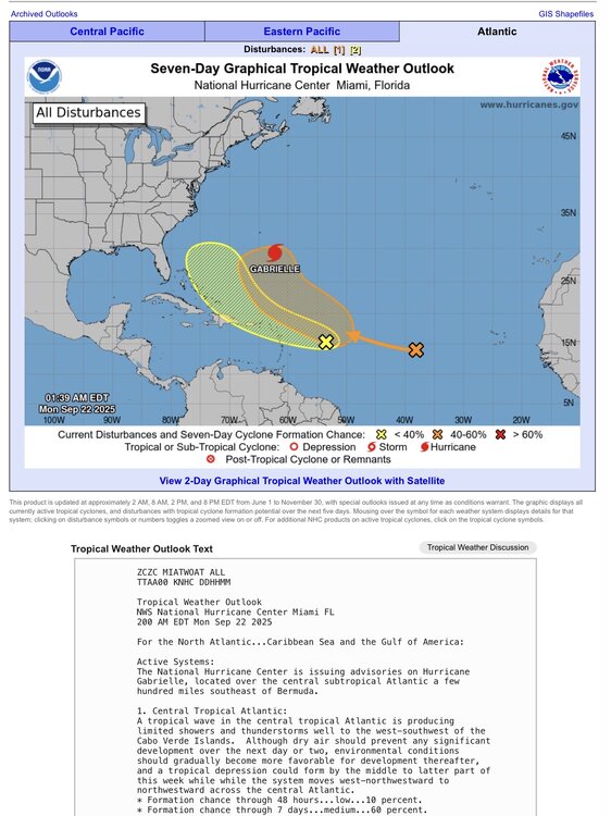
2025 Atlantic Hurricane Season
NorthHillsWx replied to BarryStantonGBP's topic in Tropical Headquarters
I believe the switch in the northern hemisphere has just flipped -
Yeah but the areas that need the most will get the least. CT jackpot for rain.
-
40 for the low, felt great on the morning walk.
-

September 2025 OBS-Discussion centered NYC subforum
steve392 replied to wdrag's topic in New York City Metro
48 and crisp this morning in Mahwah. Felt incredible with the windows wide open and fan going. - Today
-

September 2025 OBS-Discussion centered NYC subforum
donsutherland1 replied to wdrag's topic in New York City Metro
With the rapid drop in temperatures last night, White Plains had its first mean temperature below 60° (59.5°) yesterday since June 2. The first such mean temperature last year occurred on September 24. The 1991-2020 normal first such mean temperature occurred on September 9. This morning, the temperature fell to 49° in White Plains. That was the second reading in the 40s this month. The last time there were at least two such days occurred in 2022 when there were four. The 1991-2020 average is 4.4 days. -

Mid to long range discussion- 2025
WinstonSalemArlington replied to wncsnow's topic in Southeastern States
With the beginning of fall, average highs now dip into the 70s. Actual temperatures will soon comply. -
And on the PAC side, this -PDO cycle has been much stronger than the last one (1940’s-1970’s). I’ve seen a few articles blaming the record low arctic sea ice on this -PDO cycle
-
Near Shirlington… my job is a Physical Scientist Federal Contractor supporting NWS Upper-Air.
-
Wildfire smoke is having an increasing US health impact. Likely also cooling our summers. https://bsky.app/profile/shannonosaka.bsky.social/post/3lz4nvt3eqc2f https://www.nature.com/articles/s41586-025-09611-w#Sec4
-
looks like the drought is over looking at the 0z models
-
 Nooooo! Looks like I’d have to reformat the links but I gotta get up early for work! I’ll do it later!
 -
An extract from Maue’s newsletter: Two more areas being watched by NHC including a new 30% yellow hatchling based upon ensemble guidance from the A.I. models. The 60% orange will be our next Invest and likely to develop into Humberto in next 5-7 days. Models also show it becoming a major hurricane on a similar course as Gabrielle. ECMWF 12-Days Integrated Vapor Transport | 12z cycle Flagship model ECMWF 12z now develops Humberto north of the Caribbean in 5-6 days … but not seeing the yellow hatchling catching fire (NHC 20%) Atlantic Satellite Imagery | Infrared NOAA Tropical Surface Analysis | 12z Sea Surface Temperature + Anomaly | ECMWF 12z Analysis Anomalously warm water centered upon Bermuda ECMWF EPS 12z Ensemble | All Cyclone Tracks Through 7-days ECMWF EPS 12z Ensemble | All Cyclone Tracks Through 12-days I see Humberto — and there are a few more tracks that randomly extend westward presumably from a leftover tropical wave — but low chances < 10% ECMWF EPS 12z Ensemble | All Cyclone Tracks Through 15-days Gabrielle and Humberto but small chance of something else (< 10%) through 15-days (October 6) AIFS-ENS Comparison at 12z | All tracks at Day 7 The A.I. trained ensembles also show Humberto … and if we look at the MSLP contours at Day 10 — a bunch of members show a TS or Hurricane from the Gulf to Bahamas. AIFS-ENS Comparison at 12z | All tracks at Day 12 Meanwhile — AIFS blows up more member tracks w/ TS/Hurricane west of Humberto in the Gulf and out of the Caribbean AIFS-ENS Comparison at 12z | Active Tracks at Day 15
-
Model runs have this taking a similar path to Gabby, but at a higher intensity. https://weather.substack.com/p/september-21-2025-sunday-hurricane
-
2025 Atlantic Hurricane Season
Michelle Davies replied to BarryStantonGBP's topic in Tropical Headquarters
Major is indicated for the mandarin according to model guidance https://weather.substack.com/p/september-21-2025-sunday-hurricane -
It may be starting to take off with deep convection now wrapping fully around the center. It has a narrow window before environmental conditions become more hostile but the once anemic Gabby may put on a show before the curtain falls.
-
 It’s a spectacular system


.thumb.png.4150b06c63a21f61052e47a612bf1818.png)


