All Activity
- Past hour
-
I’m leaning not a huge deal outside of minor stuff. Beaches of CT could get a good one.
-
We just don’t know
-
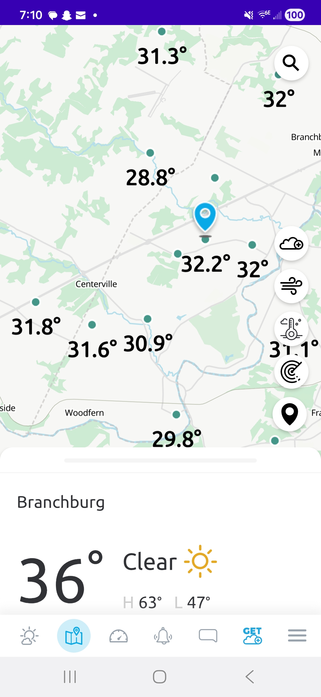
Down to 29 and holding on flipping the heat switch. Also some frost on the pumpkins. Wow that’s chilly, 65 in my house currently.
-

E PA/NJ/DE Autumn 2025 Obs/Discussion
BBasile replied to PhiEaglesfan712's topic in Philadelphia Region
First frost this morning. Low was 37.2F. -
 This is hilarious, the diffrerences on the models between 18z, 0z and this morning's 6z are insane.
 -
41 here too.
-
 All the watches and alerts were posted by NWS yesterday afternoon (9th/20z). Not changing this headline. Am not thinking any different-likely not worse than posted. Will adjust this as an OBS thread tomorrow. BUT... if anything, am not seeing the kind of phaser that was implied approaching thread post time (740PM Wed eve). Ensembling suggests the Great Lakes closed low short wave is tracking a little too far northeast to completely phase with the southern trough... instead a weaker wet windy scenario with impacts but certainly no greater than the thread headline. There is still time for the worst case coastal hugger scenario but am thinking that this won't be quite as alarming... welcomed rain, a few power outages and certainly moderate coastal flooding for 1 to possibly 3 high tide cycles. While major is still possible, I think less chance of major than what I saw 2 days ago. Again... still a problem for the involved coastal communities. On tidal predictions: when you look at the various model predictions, the GEFS suite is worst, and associated with the more closer coastal hugger scenario. I now have to consider the NAM/EPS/ECAI scenarios of a little further east (00z/10 cycle trends) On tides: am not sure why a few folks are saying astronomically large departures---NOT TRUE. We're out of the full moon phase. Someone please clarify. So, a decent storm but unless modeling changes... am not changing headline as written and presuming everyone has enough information to plan/avoid/mitigate the coming adverse impacts. Will recheck late today...
 -
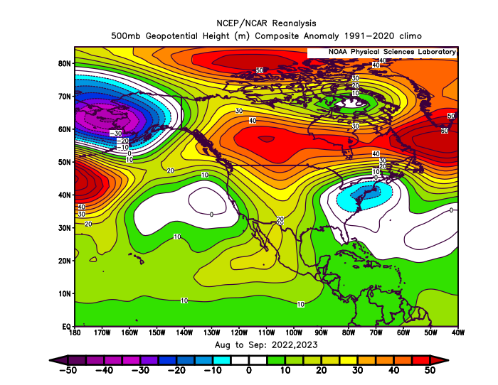
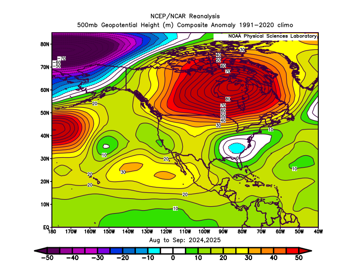
This has pretty much been our default August and September pattern since 2022. Strong blocking in Canada with a weak low near the Northeast. Impressive to get a similar pattern for 4 years in a row.
-
Well if one camp is right and the other wrong, there will be a very big difference in sensible weather.
-

Central PA Fall Discussions and Obs
Superstorm replied to ChescoWx's topic in Upstate New York/Pennsylvania
34F this morning. Lots of frost around! . -

The return of the elusive Nor'easter. Drought buster or bust?
dailylurker replied to dailylurker's topic in Mid Atlantic
Yay. Days of drizzle and wind. The boring streak continues. -
There’s enough agreement to know it’s gonna rain, but I don’t think this is gonna be a huge deal overall. They’ll probably a little bit of wind damage on the south coast or CT and over southeast mass.
-
41 here
-
30 degree's in Mahwah when i got here. WOW, that was refreshing feeling walking in.
-

Spooky Season (October Disco Thread)
Baroclinic Zone replied to Prismshine Productions's topic in New England
30-31 here. frosties all around -
36 here.
-
Leave it for me to have a long weekend planned in Hilton head this weekend. Grrrr. Rainy and windy today and tomorrow....FUN??? Yet back at home in the ATL area gonna be beautiful with Sunshine and 80. As a matter of fact looks to be in the low 80's with sunshine for the next 10 days. DRY as a bone around here.
-

Spooky Season (October Disco Thread)
Damage In Tolland replied to Prismshine Productions's topic in New England
37.1. I was too cold by 2 degrees. So fake . Growing season carries on and on and on -

The return of the elusive Nor'easter. Drought buster or bust?
TSSN+ replied to dailylurker's topic in Mid Atlantic
I mean it’s been with pretty much anything lately even a cold front passage haha. It’s just best to temper expectations till 2-3 days out then don’t have to have meltdowns when things go to crap. -
31.8, some upper 20s within a mile

-
Glad to see we have zero agreement and we are two days out.
-

The return of the elusive Nor'easter. Drought buster or bust?
WxUSAF replied to dailylurker's topic in Mid Atlantic
Forecast is always going to be very razor-edge when you’re counting on a phase happening right on top of us essentially. The “locked in” coastal storms phase much farther southwest. -

Spooky Season (October Disco Thread)
Modfan2 replied to Prismshine Productions's topic in New England
Down to 29F here in E CT with a light frost -

Spooky Season (October Disco Thread)
dendrite replied to Prismshine Productions's topic in New England
28.4° so far -
41 for me. No 30s. Boooo