All Activity
- Past hour
-
Pretty snowy morning. 26.4 degrees.
-
Cold to Hold the next 10 Days - 2 weeks Surge of much below normal Dec 8 / Dec 12-14, Dec 15-17
-
Moderate-heavy huge dendrites falling from the sky. MAYBE I’ll eke out 2.5-3”.
-
You all have been winning the war the last 8 years, tbh...but we oughta turn it around eventually I hope. This has been a historically odd stretch
-
2002: Dec 5 2003 Dec 5:
-
Yea, the last few frames of the radar you can see the back edge drifting east. I think the inner suburbs have about an hour's worth of snow left. Still, this is a great event!
-
I remember 92-93 for the Dec 92 and March 93 huge storms, 93-94 as being my first real winter and bitterly cold/icy, 94-95 lousy except the one snow to rain event on 2/4, 95-96 epic obviously, 96-97 entirely forgettable-don’t remember 4/1 at all which was probably a bunch of white rain here, 97-98 torch with the record El Niño, 98-99 cutter city with the strong Nina response, 99-00 as also pretty forgettable other than the late Jan 2000 system which was OK here but a lot better to the west, supposed to be a brush or out to sea.
-
Low of 19 late yesterday, low 7 this morning with 3" of snow at the stake.
-
Records: Highs: EWR: 72 (2001) NYC: 70 (2001) LGA: 69 (2001) JFK: 65 (2001) Lows: EWR: 15 (1935) NYC: 11 (1926) LGA: 21 (1942) JFK: 20 (1966*) Historical: 1886 - A big snowstorm in the southeastern U.S. produced 11 inches at Montgomery AL, 18.5 inches at Rome GA, and 22.5 inches at Knoxville TN. (Sandra and TI Richard Sanders - 1987) 1886: A southern storm dumped heavy snow up into far southwest Virginia. The storm dumped 11 inches in Montgomery Alabama and 22.5 inches in Knoxville, TN. It also dropped 25 inches in Rome, Georgia, and 26 inches in Ashville, North Carolina. 1913: Snowstorm hits Denver, Colorado from the 1st to the 6th piling up 46 inches of snow with most of the snow falling on the 4th and 5th. This is still the record for Denver as of 2010. (Ref. Denver Blizzard of 1913) 1941 - The temperature at Enosburg Falls soared to 72 degrees to establish a state record for Vermont for the month of December. (The Weather Channel) 1953 - A killer tornado hit Vicksburg, MS, killing 38 persons, injuring 270 others, and causing 25 million dollars damage, the most damage since the forty-seven days of continuous shelling the town received in the Civil War. (David Ludlum) 1968: High surf from an intense storm near Alaska swept rocks and seawater into pavilions at Onekahakaha Beach near Hilo, HI. Water reached 150 feet above the high-tide mark at Napili Beach and swept into the swimming pool and ground floor of a hotel there. (Ref. AccWeather Weather History) 1975: An F3 tornado struck Tulsa, OK during the late afternoon hours injuring 38 people and destroyed numerous structures, including homes and businesses. (Ref. Wilson Wx. History) 1981: An explosively deepening ocean storm southeast of New England caught forecasters off guard and unloaded heavy snow over New England. By the time it was all over on the 6th, Boston, MA was buried under 12.9 inches of snow. Some places south and west of Boston and in Rhode Island had over 2 feet. (Ref. AccWeather Weather History) 1982: An unseasonable upper level ridge off the southeast coast was responsible for record high temperatures from the Ohio Valley to the East Coast including: Orlando, FL: 84 °F, Jacksonville, FL: 82 °F, Augusta, GA: 78 °F, Norfolk, VA: 78 °F, Richmond, VA: 77 °F, Cape Hatteras, NC: 77 °F, Wilmington, NC: 77 °F, Columbia, SC: 77 °F, Savannah, GA: 77 °F-Tied, Raleigh, NC: 76 °F, Charleston, WV: 75 °F, Charlotte, NC: 73 °F, Atlantic City, NJ: 73 °F, Lynchburg, VA: 73 °F, Huntington, WV: 73 °F, Washington, DC: 72 °F, Wilmington, DE: 72 °F, Greensboro, NC: 72 °F, Baltimore, MD: 71 °F, Sterling (Dulles Airport), VA: 71 °F, Elkins, WV: 71 °F, Harrisburg, PA: 70 °F, Philadelphia, PA: 70 °F, Bristol, TN: 70 °F. (Ref. Wilson - Additional Temperatures Records Listed on This Link) 1984: A heavy snowfall, which began on the 4th, came to an end over central and northern Oklahoma. 6.1 inches fell at Oklahoma City, which set a new record for the heaviest snowfall for so early in the season. 10 inches of snow was measured at Skiatook, OK. (Ref. AccWeather Weather History) 1987 - Heavy snow blanketed parts of the north central U.S., and freezing drizzle produced a coat of ice up to half an inch thick in northwestern Minnesota and eastern North Dakota. Snowfall totals ranged up to seven inches at Grand Rapids MN, and 12 inches at Seney MI. High winds in the north central U.S. gusted to 63 mph at Pellston MI, and reached 70 mph at Makinaw Bridge MI. (The National Weather Summary) (Storm Data) 1988 - There was only a "flurry" of activity, as for much of the nation winter remained on hold. The cold and snow of winter was primarily confined to the northeastern U.S. Five cities in the north central U.S. reported record high temperatures for the date, including Norfolk NE with a reading of 65 degrees. (The National Weather Summary) 1989 - A warm Pacific storm system brought high winds and heavy rain to western Washington and western Oregon. Up to ten inches of rain deluged the western slopes of the Cascade Mountain Range in Washington State over a three day period, and 500 persons had to be evacuated due to flooding along the Skagit River. Up to five inches of rain drenched northwest Oregon, and winds gusted to 71 mph at Netarts. (The National Weather Summary) (Storm Data) 1996: The first of two major storms brought extremely heavy snows to interior New England. Over a foot of snow fell from Northeastern Pennsylvania to Western Massachusetts through the 6th. (Ref. AccWeather Weather History) 1998: An strong upper level and surface high pressure ridge extended from off the southeast coast bringing widespread record high temperatures from the Plains & Midwest to the East Coast. Locations setting their all-time December high temperature record included: La Crosse, WI: 67 °F, Winona, MN: 65 °F and New Hampton, IA: 63 °F. Locations reporting daily record high temperatures included: Orlando, FL: 84 °F-Tied, Montgomery, AL: 83 °F-Tied, Columbia, SC: 81 °F, Augusta, GA: 80 °F, Wilmington, NC: 80 °F, Charleston, SC: 80 °F, Huntsville, AL: 79 °F, Savannah, GA: 79 °F, Mobile, AL: 79 °F-Tied, Pensacola, FL: 79 °F-Tied, Washington, DC: 75 °F, Charlotte, NC: 75 °F, Sterling (Dulles Airport), VA: 75 °F, Atlanta, GA: 75 °F-Tied, Asheville, NC: 72 °F, Harrisburg, PA: 72 °F, Baltimore, MD: 71 °F-Tied, Toledo, OH: 66 °F, Mansfield, OH: 63 °F, New York (Central Park). (Ref. Wilson - Other High Temperatures Listed on This Link) 2001: A strong low pressure system moved northeast from southeast South Dakota into northeast Minnesota. At the same time, a strong cold front moved east across the Upper Mississippi Valley. Strong thunderstorms developed along the cold front. The winds gusted to 50 mph at New Lisbon, WI and a severe thunderstorm produced nickel size hail just south of Eyota, MN. Strong southerly winds ahead of this cold front helped temperatures to climb into the lower and middle 60s across the region. Many record high temperatures were established for the date. Locations setting record high temperatures for December included: Holland, MI: 70 °F, Flint, MI: 70 °F, Grand Rapids, MI: 69 °F, Lansing, MI: 69 °F, Sparta, WI: 66 °F and Prairie du Chien, WI: 66 °F. Locations reporting daily record high temperatures for the date included: Richmond, VA: 78 °F, Sterling (Dulles Airport), VA: 77 °F, Charleston, WV: 77 °F, Lynchburg, VA: 76 °F, Roanoke, VA: 76 °F, Raleigh, NC: 76 °F-Tied, Washington, DC: 75 °F, Baltimore, MD: 75 °F, Elkins, WV: 74 °F, Wallops Island, VA: 72 °F, Philadelphia, PA: 71 °F, New York (Central Park), NY: 70 °F, Chicago, IL: 68 °F, Bridgeport, CT: 62 °F. (Ref. Wilson Wx. - Other High Temperatures Listed on This Link) 2003 - A major winter storm impacted parts of the Mid-Atlantic and northeastern United States during the 5th-7th. Snowfall accumulations of one to two feet were common across areas of Pennsylvania northward into New England. Boston, MA received 16.2 inches while Providence, RI had the greatest single snowstorm on record with 17 inches, beating the previous record of 12 inches set December 5-6, 1981. Boston's Logan International Airport was closed briefly on the 7th as heavy snowfall made regular airport operations impossible (AFP).
-
Low of 19 late yesterday, low 7 this morning with 3" of snow at the stake.
-
It’s interesting that the rapid warming of the North Pacific could be contributing to the 2012 minimum not being surpassed due to a weakening of the AD since then. Article Open access Published: 18 November 2025 Decelerated Arctic Sea ice loss triggered by accelerated North Pacific warming over the past decade https://www.nature.com/articles/s43247-025-02882-1 This study offers fresh insights into the mechanisms behind the decelerating decline of Arctic sea ice from 2007 to 2024. We demonstrate that an SST trend in the North Pacific excites a Rossby wavetrain that propagates into the Arctic, driving a downward trend in the summertime Arctic Dipole (AD) index (−0.1 year⁻¹, p < 0.02). This shift induces anomalous surface wind patterns and colder air temperatures, fostering sea ice increases in the central Arctic Ocean near 180 °W (region 1) and the Canadian Arctic Archipelago (region 2), with trends of 0.4% year−¹ and 1.1% year−¹, respectively. These regional gains offset losses elsewhere, contributing to the observed slowdown in overall Arctic sea ice decline. Previous studies have documented the upward trend in September Arctic sea ice extent since 200734,35,36, yet its underlying cause remains unresolved. Our findings complement prior research on sea ice outflow11 and ocean heat transport13, while not diminishing their importance. For instance, southerly wind anomalies linked to increased sea ice in regions 1 and 2 (Fig. 2c, d) may reduce outflow through the Fram Strait, while northerly winds near the North Pole transport ice into region 1, enhancing its growth. Contrary to reports of an increasing AD index over the 2007–2024 period relative to the 1992–2006 period13, we attribute the deceleration to a declining summertime AD index, driven by North Pacific SST warming, which agrees with previous studies37,38. This warming, potentially tied to rising greenhouse gas emissions, merits further investigation to pinpoint its origins.
-
(002).thumb.png.6e3d9d46bca5fe41aab7a74871dd8af8.png)
E PA/NJ/DE Winter 2025-26 Obs/Discussion
ChescoWx replied to LVblizzard's topic in Philadelphia Region
Snowing on the beaches in SJ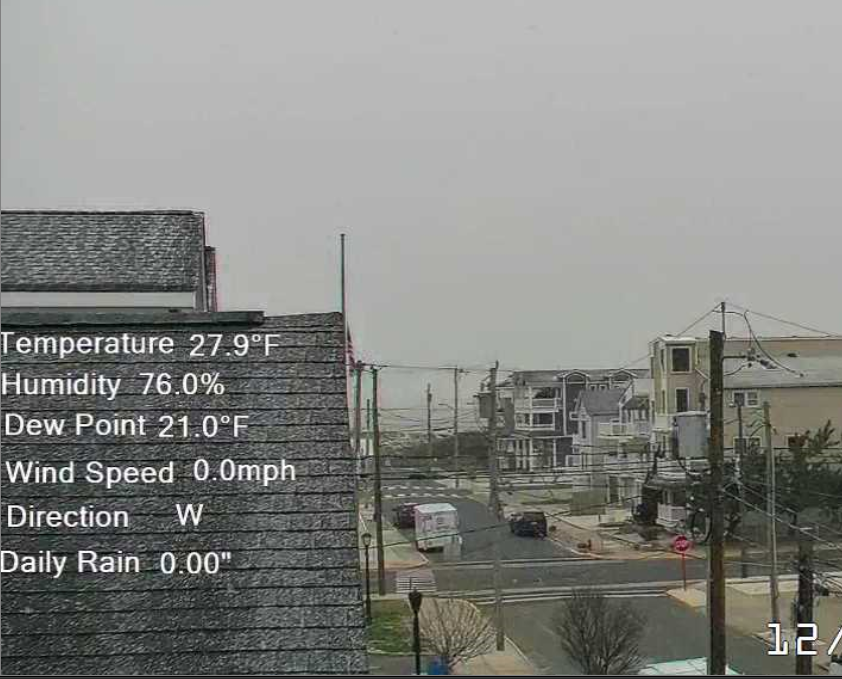
-
yes. we win a battle or two...they will win the war
-

December 2025 regional war/obs/disco thread
Typhoon Tip replied to Torch Tiger's topic in New England
We talked about this a bit yesterday ...so what, 5 pages ago? anyway, yeah ...most posters involved in that exchange agreed, me merely "suffer" ( depending on subjective perspective ) through a time that is unrepresentative of that longer termed reality. I also want to point out... last year (and I think a couple of other years since 2020 for that matter) Eurasia over into Russia/Asia itself, went through perhaps counter-intuitive excessively cold periods - if memory serves, they tended be front winter when they occurred, but I'll have to look. It is interesting that despite the global this and that, the empirical/realized data shows that both things are true: The world is both warming in total, while seated within ... there is also gasping cold. -

The Return of the 12/5 Snowstorm
NorthArlington101 replied to SnowenOutThere's topic in Mid Atlantic
December climo these days is 0” so I’d say probably -
Hey hey! No cheating with a snowflake pattern on your clothes! Juicing your flake count--DISQUALIFIED!!
-
Exactly 3.5 on the back deck - A very solid start to winter..
-
I actually noticed that on the car dash this AM. It was 4 degrees when I left the house and 17 degrees when I pulled up to 69th and cottage
-

December 2025 regional war/obs/disco thread
Sey-Mour Snow replied to Torch Tiger's topic in New England
December miracle for CT would be 1-2" for a narrow band .. just whitening up the landscape would do a lot for myself and many weenies on here as we wait for a real storm in this pattern. -
Friend just measured 1.7" on his snowboard in Leesburg. Final band might push it to 2?
-
1989/1990 season is a good example. Record cold December followed be record warm January and February (snowy March). Today some sites are breaking 1989 records.
-
The only thing you might be able to argue is that perhaps 80 years ago some of these borderline events would’ve been a little more snow on the coast.
-
Best wishes!! A Dec 5th snow baby...your snow weenie friends approve Immediate powder dusting here.
-
There’s definitely an Enso variable. I mean the storm track has just sucked for us and benefited others.
-

December 2025 Short/Medium Range Forecast Thread
Daniel Boone replied to John1122's topic in Tennessee Valley
After the shafting we Tennessee Valley Folks got from this one hopefully we get lucky with the other's up the pipeline. I had a light dusting from this one. Blacksburg about 5". Even Danville at about 800ft elevation in South Central VA near the NC Line has 3" and still snowing.


