All Activity
- Past hour
-
I was messing around with decades-old tornado outbreaks. It seems that May 1995 was had a near-record high 392 tornadoes (month of May only.) I'm not really sure which May had more tornadoes, but obviously we can say that April 2011 had more. Many tornadoes affected Illinois.
-
Hwrf into Hatteras
-

2025-2026 ENSO
40/70 Benchmark replied to 40/70 Benchmark's topic in Weather Forecasting and Discussion
Wait 3 weeks before winter and Chris will hook it up. -
2025-2026 ENSO
40/70 Benchmark replied to 40/70 Benchmark's topic in Weather Forecasting and Discussion
A good exercise I like to participate in is "opposite outcome"....give me a few examples of why this season could turn out more favorably from the perspective of snow/cold enthusiasts, than you envision....it helps to guard against preconceived thought processes, which is something we are all guilty of from time to time. -
95 at 3:10. Go away, I can't have Oktoberfest with this weather! Eyeing that possible low of ~49 next week.
-

2025-2026 Fall/Winter Mountain Thread
Maggie Valley Steve replied to Buckethead's topic in Southeastern States
Big slow moving storms moving into the far SW Mountain Counties. GSP stated in their afternoon disco that rain chance increase over the Mountains overnight into tomorrow morning. Nothing looks severe, but there is so very rich tropical moisture out there and heavy rainfall is a possibility. -

2025 Atlantic Hurricane Season
hawkeye_wx replied to BarryStantonGBP's topic in Tropical Headquarters
Another wild 18z Euro run.... has a 966 mb and a 933 mb hurricane off the coast.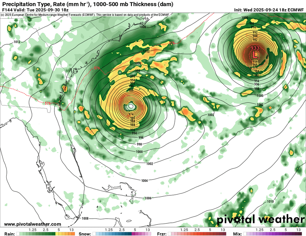
-
 Humberto brings the count to 8/2/2 and the forecast gives me enough confidence to score from 8/3/2. Apparently there is some potential to go to 8/3/3 eventually and if so the scoring will be adjusted. It will improve all scores except two already at zero error for two majors; those two scores would drop by 1.0. Scores with errors of 1 for major hurricanes will improve by 1; scores with errors of 2 will improve by 2 (from 3 to 1 error deductions); scores with errors of 3 will improve by 3, etc.
 -
2025-2026 ENSO
40/70 Benchmark replied to 40/70 Benchmark's topic in Weather Forecasting and Discussion
If you have been reading my blogs, you would know I expect neither wall-to-wall -WPO of -EPO...that said, show me on the doll where the negative modes of those respective teleconnections hurt you? It's okay to mention them.... -

E PA/NJ/DE Autumn 2025 Obs/Discussion
Kevin Reilly replied to PhiEaglesfan712's topic in Philadelphia Region
Humberto yea moves towards Bermuda then out to sea. I am pretty sold on that. However, what is south of Puerto Rico I am not so sure. That would become Tropical Storm Imelda. I would think Imelda is a threat to the United States East Coast South Carolina to New England. Humberto leaves stage right then high pressure builds and traps Imelda forcing Imelda toward the United States East Coast next week. Time to watch, I think. I am always weary of tropical systems developing in September and October down near Puerto Rico Hatti because chances are they are heading up the east coast with troughness around to our west and high pressure to the east. -
Same s*** different day.
-
probably cirrus... but we track. there are a few ways that can change though
-

September 2025 OBS-Discussion centered NYC subforum
Stormlover74 replied to wdrag's topic in New York City Metro
Getting a downpour now -
My bias is not part of this conversation. I know you’re ready to start one of your 5th grade personal attacks
-

September 2025 OBS-Discussion centered NYC subforum
SACRUS replied to wdrag's topic in New York City Metro
Highs TEB: 82 * EWR: 81 New Brnswck: 81 ACY: 80 PHL: 80 ISP: 80 NYC: 80 BLM: 79 TTN: 79 JFK: 78 LGA: 78 -
Reminds me of the "Video Professor"
-
I've cracked double digits!!!!!! 0.10"$$$$$$$$$$$ Sent from my SM-X210 using Tapatalk
-

2025-2026 ENSO
donsutherland1 replied to 40/70 Benchmark's topic in Weather Forecasting and Discussion
Convection during neutral ENSO events is more evenly spread out; during La Niña it's farther west (often but not always in the vicinity of the Maritime Continent); during El Niño, it's located in the cental/eastern Pacific. Depending on how the atmosphere and ocean couple, these differences matter. MJO phases in the Maritime Continent often favor warmth in eastern North America. ENSO, of course, is but one variable that shapes seasonal outcomes. Other variables can outweigh it. -

-
What is the ceiling of potential impacts in Templeton, MA? Irene level flooding?
-

September 2025 OBS-Discussion centered NYC subforum
Sundog replied to wdrag's topic in New York City Metro
They have lowered altitude significantly unfortunately. For me it's takeoffs from LGA. I can clearly read the writing on the planes with a quick phone pic. Sometimes I say to my wife I think they're going to land on the boulevard nearby they're so damned loud and low. -
September 2025 OBS-Discussion centered NYC subforum
Sundog replied to wdrag's topic in New York City Metro
Maybe KDIX can get its act together and clean up the radar. -

September 2025 OBS-Discussion centered NYC subforum
uofmiami replied to wdrag's topic in New York City Metro
I get non-stop planes overheard on approach into JFK runway 22 now at 1800 to 2000 over my house & my parent's in Muttontown. Can always tell a 747 by the sound alone. While planes flew over Great Neck from LGA when I was kid & lived for 30 or so years, they were always at a higher altitude so not as noisy in my experience. -
How can the ENSO cool and La niña composites have completely opposing temperature anomalies in the eastern US? The temperature of the tropics can't have been that different in these two scenarios, why would its effect suddenly reverse?
- Yesterday
-

September 2025 OBS-Discussion centered NYC subforum
ForestHillWx replied to wdrag's topic in New York City Metro
Decent shower rolled through, now a line is forming north of 78.


.thumb.jpeg.406ecda2eec9e267302c22b9f128fe3c.jpeg)