All Activity
- Past hour
-
Ok yeah. When you burn a month in La Niña early on, usually a bad thing. There were places close to the coast in E MA that got skunked in Nov ‘71 but still recovered. Obviously rare though…Feb ‘72 was a huge month despite La Niña. Usually February is the weakest La Niña month.
-
Think he is station at YYT St. John’s. Rodney Barney from the ol ne.weather days is in YQX Gander. They’ve already gotten a boatload of snow so far. They in the crosshairs…for now.
-
congrats powderfreak
-
Gusty shower line to close out 2025? Friday AM?
-
The Allegheny Front does weird things.
-

December 2025 regional war/obs/disco thread
40/70 Benchmark replied to Torch Tiger's topic in New England
I am talking about the seasonal total after the seasonal tally at the end of December is in single digits. -
How has the long range euro AI been performing? I know it's long range but one can dream.
-
(002).thumb.png.6e3d9d46bca5fe41aab7a74871dd8af8.png)
E PA/NJ/DE Winter 2025-26 Obs/Discussion
ChescoWx replied to LVblizzard's topic in Philadelphia Region
Today will be near to slightly above normal with highs in the middle 40's. We warm a bit more tomorrow into the upper 40's and then the low 50's by Friday. Rain arrives by Thursday night and would expect to see some areas of fog as the snow melt ramps up tomorrow night. We could see 3/4 to an inch of rain. We then turn colder again for the weekend and into the start of Christmas week.
-
Central PA Winter 25/26 Discussion and Obs
ChescoWx replied to MAG5035's topic in Upstate New York/Pennsylvania
Today will be near to slightly above normal with highs in the middle 40's. We warm a bit more tomorrow into the upper 40's and then the low 50's by Friday. Rain arrives by Thursday night and would expect to see some areas of fog as the snow melt ramps up tomorrow night. We could see 3/4 to an inch of rain. We then turn colder again for the weekend and into the start of Christmas week.
-

2025-2026 ENSO
JenkinsJinkies replied to 40/70 Benchmark's topic in Weather Forecasting and Discussion
I have a feeling that Webb is going to ride the torch wave until the very end. -
what is it if you remove the 17 -19th and calculate from the 20th to the 31st ?
-

Winter 2025-26 Medium/Long Range Discussion
Frog Town replied to michsnowfreak's topic in Lakes/Ohio Valley
Take away...when you buy a snowblower, it doesn't snow and when you get rid of it, it does. -
If we can get that trough to back up west a lil
-
‘71-72? November ‘71 was good but Dec ‘71 was kind of a dud for snow.
-

December 2025 regional war/obs/disco thread
WxWatcher007 replied to Torch Tiger's topic in New England
I like that pre Christmas window more than trying to thread the needle on Christmas. I’m not as confident in that signal. I mean in all seriousness, last year we had epic patterns showing up and that was awful. We’ve had bad patterns be awful. We’ve had middling patterns be awful. It’s a rough decade. Yes, there have been great storms, but on balance nothing has worked with the PAC being uncooperative. I lean more toward you here. I don’t think it’s permanent, but perhaps one of these longer range oscillations that are really a blip on the global time scale but suck for us. 100% We have to be at climo by Dec 31. -
Yeah that’s a split flow, we’ll see if it has legs as we get closer. .
-
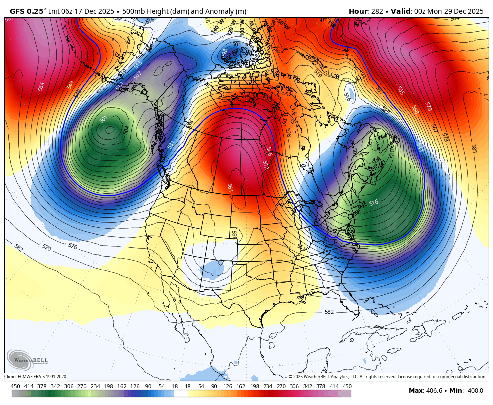
Hmm yeah there are similarities. Euro AI has that giant tropospheric PV in Canada provide just enough confluence without squashing it. GFS squashes it. High latitudes on euro AI otherwise look like trash at that time frame lol. Definitely a unicorn setup but not much else happening…
-

Central PA Winter 25/26 Discussion and Obs
TheClimateChanger replied to MAG5035's topic in Upstate New York/Pennsylvania
BIG changes underway. That snow and ice doesn't stand a chance. -
December 2025 regional war/obs/disco thread
40/70 Benchmark replied to Torch Tiger's topic in New England
No, the end of December. This is for my area....tri state as done okay. -

December 2025 regional war/obs/disco thread
Snowcrazed71 replied to Torch Tiger's topic in New England
When you say soon, you meaning by the end of January? I mean, things really shouldn't get going climatologically as far as snow in our region, especially Southern New England and the Tri-State area ( although south of us have done very well and are above average I would say for the month of December and are above average I would say for the month of December). Even though we're not getting a parade of snow events here, I wouldn't call it horrible. -
Is 6-9" a big snow? The upper end of that is getting there. Maybe we need a woman's perspective on this??
-
December 2025 regional war/obs/disco thread
Snowcrazed71 replied to Torch Tiger's topic in New England
Man, I get the pessimism from most. I to am disappointed in how things could pan out. For now, I'm looking forward to having some real time Winter as we are taking a trip to Quebec ( right between Quebec City and Montreal ) in Shawinigan QC arriving there the day after Christmas and staying until early the next week. It's looking Snowy there, so I'm sure I will get my fix while we are there. Hopefully when I get back, things will look better going forward. -
December 2025 regional war/obs/disco thread
40/70 Benchmark replied to Torch Tiger's topic in New England
Excerpt from my latest blog: While the forecast for the balance of 2025 would appear rather unchallenging, things are seldom as they appear in weather. In this particular instance, the caveat is an MJO wave that is expected to remain rather meager and variable after having largely dissipated over the course of the past week following its brief flirtation with phase 8 near the outset of the month. Note the tendency for the MJO to stagnate and become incoherent enough in phase 8 as to actually be reflected as having reemerged into the MC phases as byproduct of the continued warmth in the western Pacific that was referenced last fall. The consistent struggle for the MJO to remain a coherent wave in the western Pacific has been a theme over the course of the past decade that any seasoned forecaster should not have neglected to consider. The disjointed signal that results from the continuation of the battle for proxy between the MC and western Pacific will allow for an occasional element of western Pacific expression to assert itself into the pattern as a byproduct of the areas of dual forcing. This will be especially prevalent during the final week of the month, which is when some potentially colder intrusions may periodically infiltrate the northeastern quarter of the country -
Like you said, grasping a little here but the Euro and the GFS have the same ULL entering Cali and trying to make its way across under the ridge. I actually thought the 6z GFS was going to do something with it but the ridge just gets bullied east and squashes it.

-

December 2025 regional war/obs/disco thread
weatherwiz replied to Torch Tiger's topic in New England
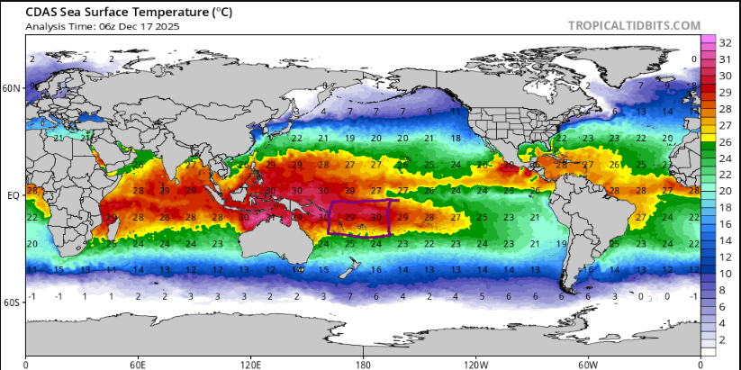
I have these thoughts too. I've been creating composites of SSTs focusing on the Pacific for EL Nino/La Nina dating back to 1900 with a focus on the WPWP. There's lots of studies out there discussing how it has expanded over the last 2-3 decades along with the extension of the WHWP. But even with the Nina look...those 29-30C temps are extending well east, just past the dateline. Definitely sufficient to sustain strong convection around the dateline which I believe is something that enhances ridging across the NPAC?