All Activity
- Past hour
-
One last day of record warm temperatures before reality sets in. Getting the last of the yard work completed and tracking 3 systems, life is good.
-

Central PA Fall Discussions and Obs
canderson replied to ChescoWx's topic in Upstate New York/Pennsylvania
Texas basketball recently had an exact same situation. When Chris Beard got fired for hitting his girlfriend, Rodney Terry stepped in and took them to the elite 8. They immediately gave him a 3 year contract. The team was garbage under his direct command and he was fired in 2 years. Be careful. -
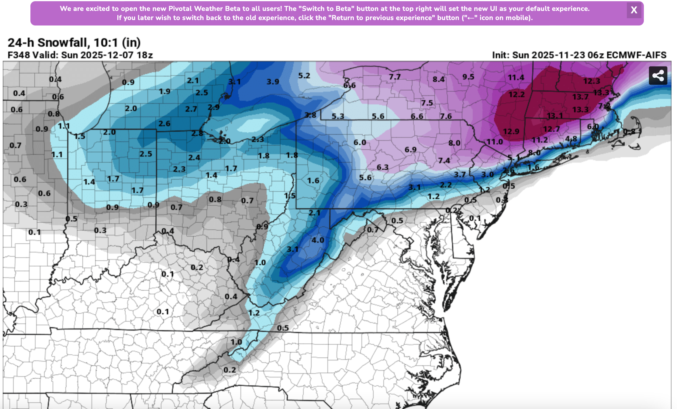
Just so everyone is aware... this is not AI Ensemble... just a single member. You'd be astounded if I posted the EC FRAM Freezing rain output from some of the recent EC cycles... ice storm big impact... fortunately ensembles temper enthusiasm and of course we're in the unreliable = beyond 10 day period when this occurs. I love EC AI but I've Zero experience monitoring beyond a week. Maybe we'll soon have occasion? I attached the most significant ECAI 24 hr 10 to 1 snowfall (not taking into account potential melting pavement). Note that most of this is in the last day or two of the 16 day cycle. I've no confidence. However, the ECAI seems a little colder than the traditional globals that we use and it has snow acc for I95 to the coast (including NYC/LI) around Dec 1-2. I need to see more support before it get enthusiastic.

-

E PA/NJ/DE Autumn 2025 Obs/Discussion
Albedoman replied to PhiEaglesfan712's topic in Philadelphia Region
Where the hell these long range so called weather gurus snow weenies seeing snow for our area on facebook and other media sources and who are just trying to make a few advertising bucks playing up the polar vortex bs but the current models are sure are NOT portraying anything like this right now for our area.. Every single snow chance has now dwindle to rain/mix event and also an insignificant rain event at best for our area as the cold dry air is winning the battle. The models have shown only one positive thing in the last two weeks for a major pattern change and a possible major snow event for us but when it will ever occur will just be plain luck. If you old timers recognize the current major pattern shift on the last weeks runs which we have not seen in nearly 6-10 years is identified as the four corner lows which are developing and pushing into the Gulf of America. Then these lows are quickly re-energized with a ton of moisture and are setting up for a good Miller A type of storm event- rain or snow along the east coast. The lows south of New Orleans into Tampa are impressive on the model runs. This is the best look in model runs in a long time as it appears the GOA is opening back up for business, however these low pressure systems are also quickly becoming southern sliders too. The cold dry air that does come through with a cold front is NOT retreating back up into Canada so quickly before the moisture reaches us. Would not be surprised if the Carolina's up to Washington DC sees more accumulating snow then us this year. This pattern is slowly setting up for a lot nuisance mix storm events snow/sleet to rain for our area if this keeps up. A pure snow event will be hard to come by in the next few weeks I basically want a 2-4 in long duration three day rain event asap to get the trees feet wet before the ground freezes and to get runoff back into the soon to be dry streams. Trout fishing and landscaping this spring will be severely hampered too if you do not get some significant rains in the next 2-3 weeks. When LCA declares a drought watch folks,its pretty serious. I have USGS gauging stations in my backyard for the Little Lehigh and if this stream dries up, the businesses will be greatly affected too throughout PA -
39 / 30 cloudy off a low of 26 here. Clouds should hopefully clear later this afternoon. Warmer through Wed (some showers / lght rain Tuesday)( then Thursday transitions to colder. A bit back and forth the next 10 days to two weeks and an option to be caught in the middle as this current warm up didnt fan out to what it could have been the Dec 2 - 7 one may be muted as well to a more cloudy /wet one but deep trough to the west and strong ridge in E ahead of the next trough with deep cold building north/west. 11/23 - 11/26 : Above normal - rain Tue 11/27 - 12/1 : Colder than normal - overall 12/2 - 12/6 or 7 : Warmer than normal / could be cloudier / wetter or potential stronger warmth - departures.
-
Truly excellent work. Thank you!
-

November 2025 general discussions and probable topic derailings ...
das replied to Typhoon Tip's topic in New England
The lowest low here in Charlotte has been 21.2°F. If we hit 50°F on Wednesday (increasingly unlikely), it’ll be the first >50’s since the 8th. Days and days of 30’s and 40’s for highs. Chilly but not cold. -
Yeah unfortunately the RNA creates a SE ridge, and without blocking can facilitate cutters. This really feels like the old fashioned warm wet, cold dry years of the past. Last year we had plenty of cold but remained dry.
-
(002).thumb.png.6e3d9d46bca5fe41aab7a74871dd8af8.png)
Central PA Fall Discussions and Obs
ChescoWx replied to ChescoWx's topic in Upstate New York/Pennsylvania
After a frosty start in spots, we should see sunny skies with temperatures not too far from normal for both today and tomorrow. Rain chances increase by Tuesday afternoon with some spots seeing the potential for up to 0.50" of rain before it ends on Tuesday night. Wednesday looks like our one warmer day before we turn back to well below normal temperatures for the Thanksgiving Holiday and weekend.

-
E PA/NJ/DE Autumn 2025 Obs/Discussion
ChescoWx replied to PhiEaglesfan712's topic in Philadelphia Region
After a frosty start in spots, we should see sunny skies with temperatures not too far from normal for both today and tomorrow. Rain chances increase by Tuesday afternoon with some spots seeing the potential for up to 0.50" of rain before it ends on Tuesday night. Wednesday looks like our one warmer day before we turn back to well below normal temperatures for the Thanksgiving Holiday and weekend.
-
I mean if all it takes is a cold Siberia and warm Pacific to end winter then we are never going to get cold and snow ever again
-
Sunday low imby/Columbia a toasty 34°.
-
 Well there, you have it. Winter's canceled. Nothing good is going to happen. On to next winter. I guess we'll see you on here then.
 -
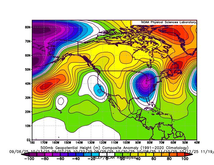
During more +PNA intervals like this fall the, the Southeast ridge was focused to the east building into Eastern New England and Canada on our 10 wettest storm days. So these frequent WAR and Southeast ridge patterns are interchangeable. They both have been leading to dominant Great Lakes cutter and hugger storm tracks whether we have had +PNA or -PNA patterns over the last 7 years since 2018-2019. 10 wettest days storm track 500 mb composite this fall around the area with dominant Great Lakes cutter and hugger storm tracks and strong +PNA WAR pattern
-
Like I said, hes pushing 50 and banned from multiple boards for years for being an idiot. Some people dont grow up. 25 this morning, coldest of season so far
-

November 2025 general discussions and probable topic derailings ...
WinterWolf replied to Typhoon Tip's topic in New England
But It’s also been consistent…that was my point. Doesn’t mean anything with regard to the upcoming winter season, just like only a couple coastals means nothing either..only that it has been consistently cool/cold for autumn and November. -
Let's see how the AI model performs in December -will it show some consistency moving forward ?
-
 Watching this right now…
 -
I'm never cooked, only relaying information. My realistic views usually serve me well!
-
The dry part is more concerning than the warm part IMO
-
November 2025 general discussions and probable topic derailings ...
WinterWolf replied to Typhoon Tip's topic in New England
Agreed. It’s a different year, we’ll have our chances. -
Maybe no one on here but plenty of people have. Also , no clue why are you throwing in the towel in November. You do this all the time.
-
Literally no one is predicting December to be cold and active
-
27 here earlier this morning, frosty