All Activity
- Past hour
-
All you gotta do is look at last years…abysmal performance by them.
-
Another one for the fakers
-
 http://cangetrx.com/# reliable canadian pharmacy
 -
mexico pharmacy order online delivery [url=https://mexgetrx.shop/#]mexican pharmacy prices[/url] mexican online mail order pharmacy
-
Looks perfectly seasonable to me for the metro. Mid to upper 60's most days (maybe some 70's in there) with lows in the 40's. Can't get much better for October.
-

2026 Mid-Atlantic Severe Storm General Discussion
high risk replied to Kmlwx's topic in Mid Atlantic
The minimum is probably a line of heavy showers with gusts to 30-40 or so. The higher end is widespread gusts to 50 and some localized 60, with maybe a brief spinup or two. Probably at least a few scattered lightning strikes if we can get some heating. -
My stance has and still is: -whereas CC/AGW has its clearly detrimental effects and thus I’m not happy about it (plus I selfishly prefer cold over warmth way down here in the deep SE), its effects aren’t all bad and are naturally largely being ignored by the extreme doomsayers. I‘m referring mainly to the increased greening of the globe that has occurred due to increased CO2 and also the reduced number of deaths from cold, which has killed many more than heat per organizations that compile the stats even though the balance could change if it gets hot enough, of course -there very could be some negative feedback loops that aren’t being modeled well as regards how much warmer it will ultimately get, which if true would mean that the worst case scenarios aren’t realistic
-
canadian pharmacy price checker and online canadian drugstore reliable canadian pharmacy http://images.google.com.sv/url?q=https://cangetrx.com canadian pharmacy checker and https://armandohart.com/user/arpqkeeswe/?um_action=edit legitimate canadian online pharmacy [url=https://toolbarqueries.google.ki/url?sa=t&url=https://cangetrx.com]canadian pharmacy 365[/url] canadian pharmacy official website or [url=http://lenhong.fr/user/axsjqezlko/]canada pharmacy online[/url] safe canadian pharmacy
-
That’s at 6z too. Sunday morning is light winds.
-
canadian pharmacy price checker and online canadian drugstore reliable canadian pharmacy http://images.google.com.sv/url?q=https://cangetrx.com canadian pharmacy checker and https://armandohart.com/user/arpqkeeswe/?um_action=edit legitimate canadian online pharmacy [url=https://toolbarqueries.google.ki/url?sa=t&url=https://cangetrx.com]canadian pharmacy 365[/url] canadian pharmacy official website or [url=http://lenhong.fr/user/axsjqezlko/]canada pharmacy online[/url] safe canadian pharmacy
-
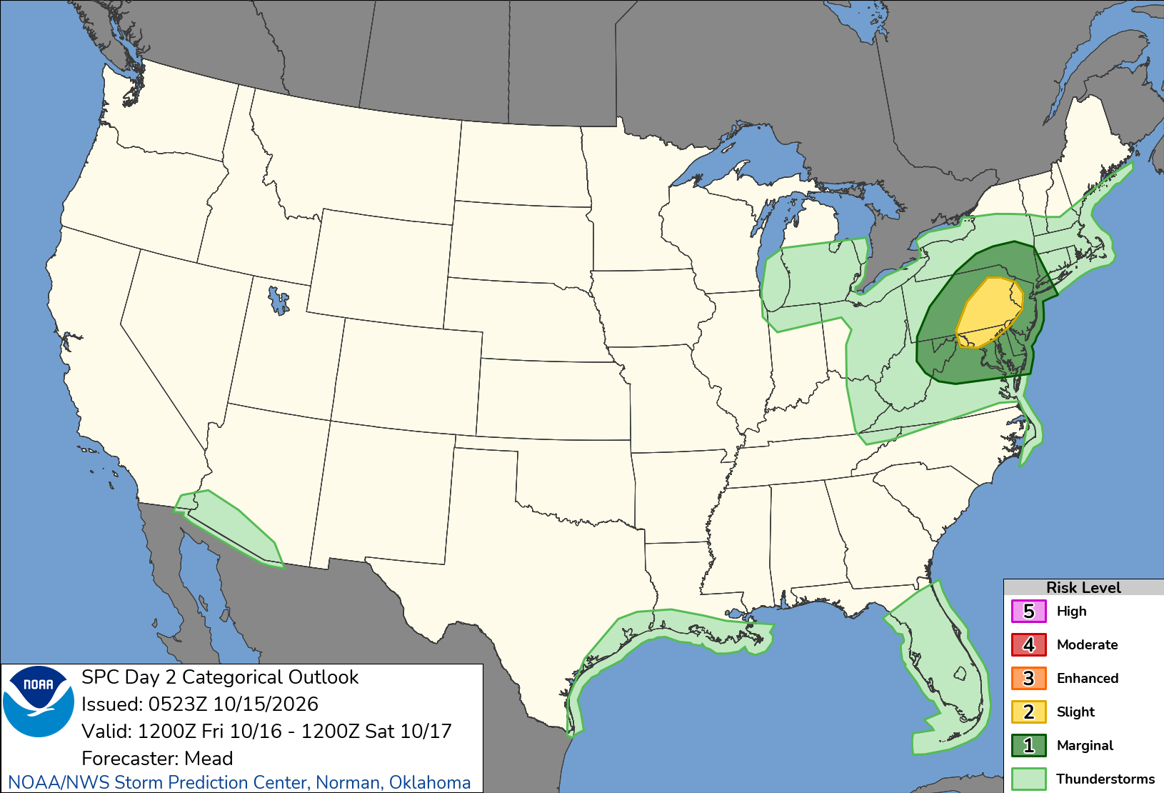
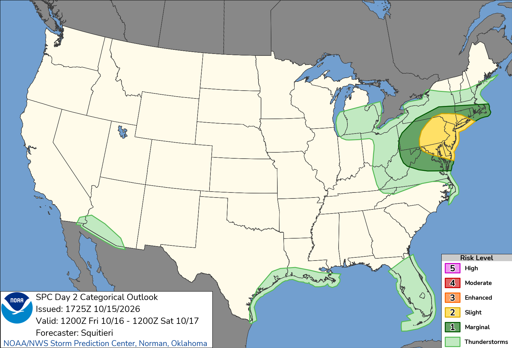
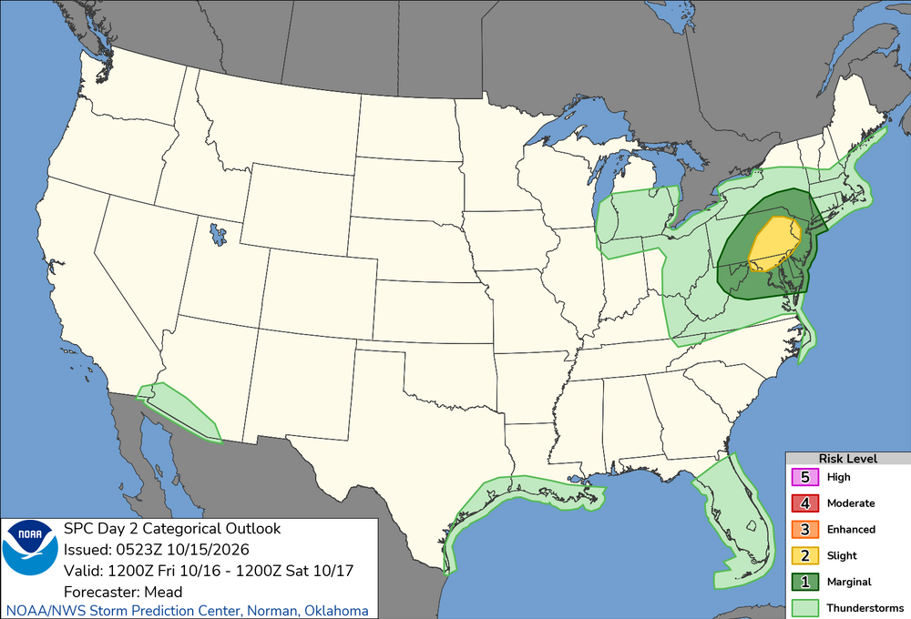
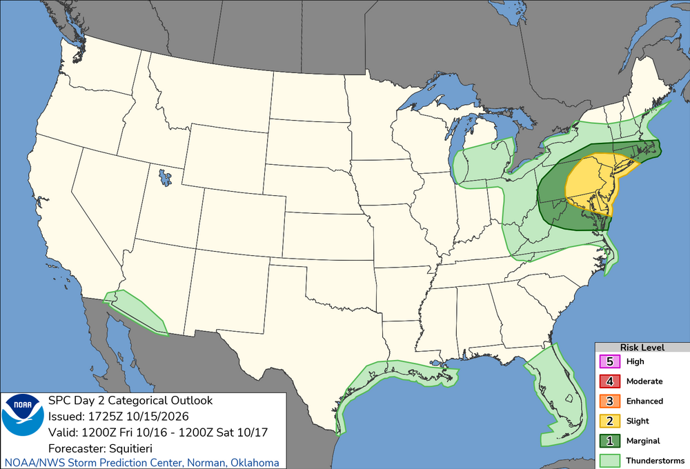
..Mid-Atlantic into southern New England... As the upper trough amplifies and the surface cyclone deepens over the northern Appalachians, low-level convergence along the attendant surface trough will increase into the morning hours, resulting in the development of low-topped convection that will quickly evolve into a squall line across western NY/PA. The northward advection of mid 60s F surface dewpoints beneath 6 C/km mid-level lapse rates will result in 500 J/kg MLCAPE on a widespread basis ahead of the line, with locally higher values approaching 1000 J/kg in spots. Some guidance members suggest that surface airmass recovery may be brief ahead of the squall line given the potential for widespread antecedent cloud cover. Still, strong tropospheric wind fields will accompany the squall line, with forecast soundings showing 50+ kt flow as low as 800-700 mb, with 35-40 kt flow contained within the boundary layer, just above the surface. Regardless of the degree of destabilization that precedes the squall line, downward momentum transport of the stronger flow aloft within the squall line should support strong to occasionally severe surface gusts, mostly in the 35-55 kt range. Scattered instances of tree/wire damage are expected, starting from around western PA during the late morning hours, to the East Coast around early evening.
-
Way too cold here
-
Big change with the afternoon update
-
30% wind added for NE MD into SE NY on 1730z SPC OTLK
- 2,568 replies
-
- 1
-

-
- severe
- thunderstorms
- (and 7 more)
-

2026-2027 Fall/Winter Mountain Thread
Maggie Valley Steve replied to BlueRidgeFolklore's topic in Southeastern States
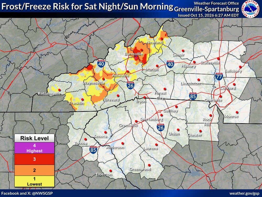
It's that time of year!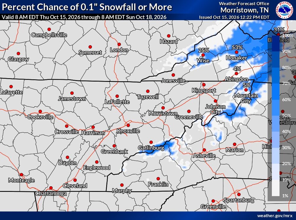
-
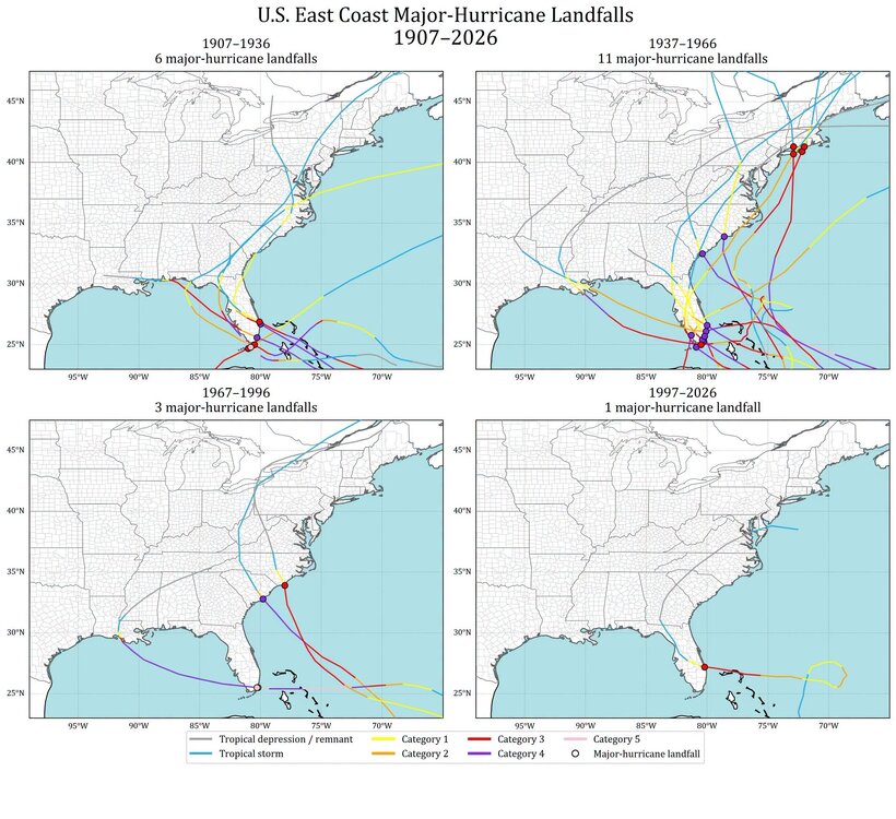
No disagreement. We are definitely in an unprecedented period of hurricanes somehow missing the northeast. Though if you look at the frequency of majors it’s not that far off. Going back using sediment data to around 1000 the reoccurrence rate is about 100 years. So Carol 54 technically being the last, we are due. .
-

2026-2027 Record-breaking El Nino
40/70 Benchmark replied to Stormchaserchuck1's topic in Weather Forecasting and Discussion
That guys has always put out crap...it was previously organic crap, now it's chemically treated with AI. -
Fake cold always over achieves. Real cold always under-achieves
-
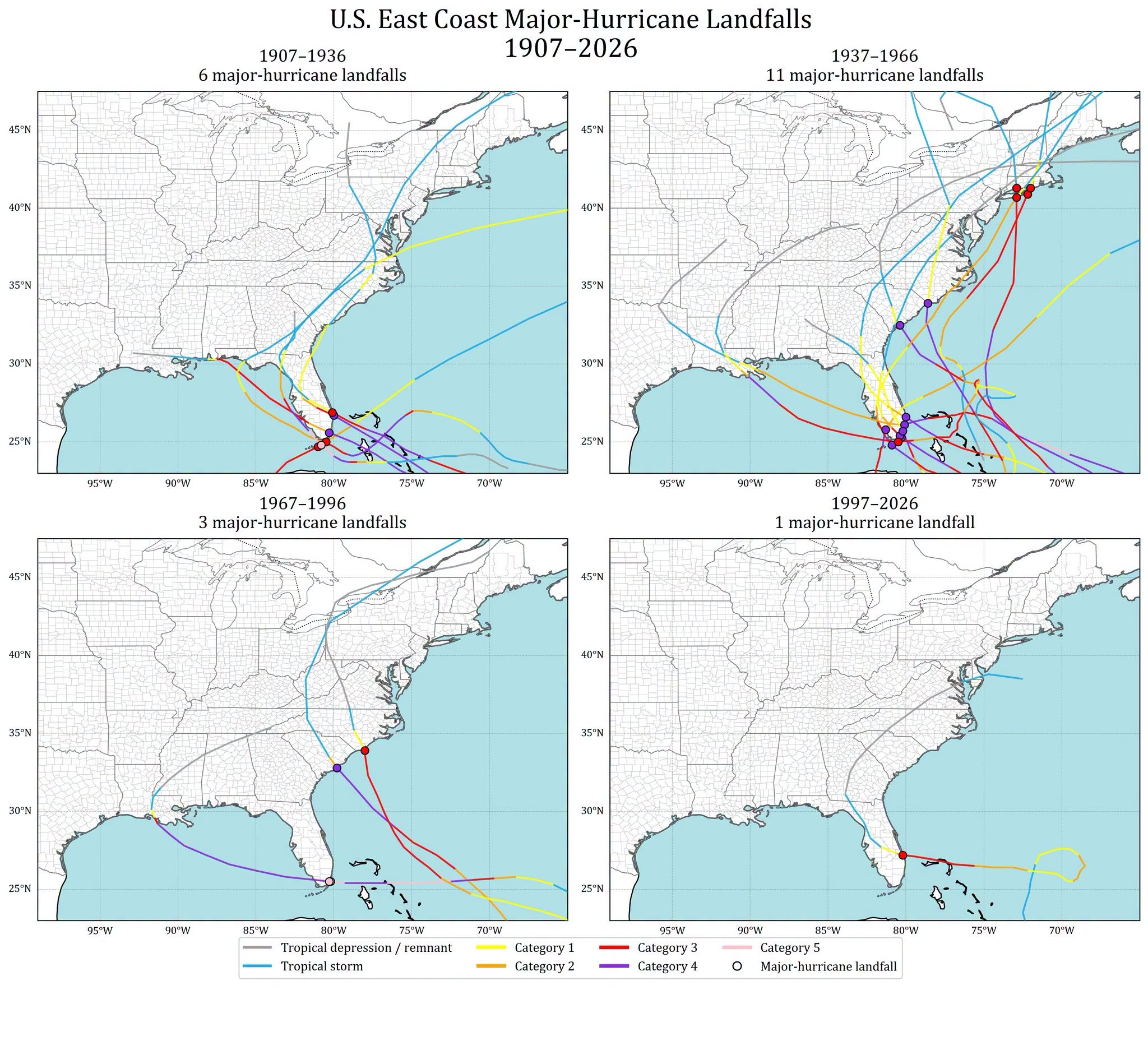
The AMO cycles 25-45 years based on the Atlantic HU activity going back to the late 19th century. We are in year 32 of the active phase, so it could end any year now. Regarding E Coast landfalls, it depends on how you look at it. If you go by major HU E Coast landfalls, events are *way* down in the last 60 years compared to the previous 60 years. See graphic attached. There has not been a major HU landfall GA to ME since Fran in 1996. And for the entire E Coast, not since Jeanne in 2004. And I would argue this is the most important stat when considering changes/trends over time b/c major HUs do a disproportional amount of impact/damage. And I know one can say, "well, what about Gulf landfalls?" That is valid statement, as those show a different trend. However, what I find far too often is that facts/data are cherry-picked, and the omission of key facts/data is really no different that lying. The point is that one needs to include all valid/relevant data when making claims for changes/trends and look over long periods of time, not hyper-focus in short-term snapshots and run w/ that as if that how it is going to be proves one point. Unfortunately, the MSM and too many on social media largely ignore this and run w/ whatever gets eyeballs/clicks/likes best, and that is gloom and doom and the end is nigh. There is a saying here, "never let the facts get in the way of a good story." For any HU landfall for a E Coast location, New England has not have one since 1991, its longest or 2nd longest gap period on record (depending on landfall definition). So it is not just anecdotal that things are not as frequent of bad for the E Coast. Actual hard data support it.
-
give me 60s through Novie, with spot 70s.
-
Sell. Save your time for Winter. Looks like an easy whiff to me
-
Full rundown of 12Z main global non-AI for the possible E coast storm next week excluding the not yet released Euro: The 12Z UKMET, after 3 full runs in a row with an E coast “tropical cyclone”, has no TC and not even an E coast storm as the non-tropical low forms well offshore (300 miles) and then moves out NE from there to just NW of Bermuda. 12z Icon is much further offshore than its 0Z with little E coast effect. 12Z GFS is a bit closer (similar to the 0Z) but like for the 0Z the low still is far enough out to have little effect on the E coast as it then moves out. OTOH, the 12Z CMC is its first run with effects on the E coast with it getting caught 300 miles SE of the Carolinas and then then coming back WSW to Jacksonville on 10/23. That’s now an extreme outlier pending what the 12Z Euro shows.
-
Full rundown of 12Z main global non-AI for the possible E coast storm next week excluding the not yet released Euro: The 12Z UKMET, after 3 full runs in a row with an E coast “tropical cyclone”, has no TC and not even an E coast storm as the non-tropical low forms well offshore (300 miles) and then moves out NE from there to just NW of Bermuda. 12z Icon is much further offshore than its 0Z with little E coast effect. 12Z GFS is a bit closer (similar to the 0Z) but like for the 0Z the low still is far enough out to have little effect on the E coast as it then moves out. OTOH, the 12Z CMC is its first run with effects on the E coast with it getting caught 300 miles SE of the Carolinas and then then coming back WSW to Jacksonville on 10/23. That’s now an extreme outlier pending that the 12Z Euro shows.
- Today
-
Kind of the theme since July-warm but not the warmest as that stays to our S and W
-
mm yeah thing is, it doesn't feel that way for us here in SNE .. maybe it's this 'blazing above normal' because the nights stay hot under cooler afternoon routine that's been going on since global warming began it seems ( ) - if that is the reason for that 'faux impression' my hunch is that we will be among the coolest relative to the whole, while still being above normal?