All Activity
- Past hour
-

July 2025 Obs/Disco ... possible historic month for heat
rimetree replied to Typhoon Tip's topic in New England
77/57...couldn't draw it up any better for the 4th. Enjoy the day folks. -

July 2025 Obs/Disco ... possible historic month for heat
powderfreak replied to Typhoon Tip's topic in New England
66/50 in the valley. Bit cooler up here at the mountain. A nice break in the heat. -

July 2025 Obs/Disco ... possible historic month for heat
Lava Rock replied to Typhoon Tip's topic in New England
Gusty NW winds at the lake. Sent from my SM-S921U using Tapatalk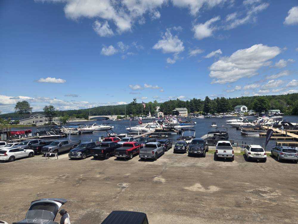
-
Early split picture showing up in the data. It was a warmer than average May across the Arctic. But not as warm as 2020 was which lead to all the preconditioning that year. June was the coolest in the Arctic over the last decade. Yet the extent is currently in 1st place for lowest in early July. But the area is only 8th lowest. Area and melt pond fraction are more important this time of year than extent in trying to guess a September low. Unfortunately, the May melt pond data still hasn’t been released. This is what the statistical model uses to forecast a June September low. If I had to take an early guess, the higher area now than extent could mean that the extent will fall behind the steep 2012 drop which happened back in early August 2012. So it’s possible that the 2012 record low will hold for another year. But I want to see the May melt pond fraction first before making a final call. I will update this if the ARCUS SPIN site gets around to posting the model forecasts for September. They have been delayed in their update.
-
Unexpected 1.2” early this AM. Garden now having a happy 4th. The brisket, however, is going to be delayed.
-

July 2025 Obs/Disco ... possible historic month for heat
weathafella replied to Typhoon Tip's topic in New England
Lovely day! I enjoy my heat but love the gathering planned in near perfect outdoor wx today. It should be hot Sunday onward for a few days and like the past few weeks, cooldowns are short lived. -
Was surprised the military planes made it this far north this morning. Had numerous fly by
-
GGEM remains consistent bringing rain from future Chantal into the area. Many runs in a row even though it has no support.
-

Occasional Thoughts on Climate Change
TheClimateChanger replied to donsutherland1's topic in Climate Change
Funnily enough, the USCRN data largely supports my contention decades ago that the US climate record likely understates the change. If you accept USCRN as the gold standard, then, you must conclude nClimDiv [and the older USHCN] clearly understates warming in recent decades. -
Occasional Thoughts on Climate Change
TheClimateChanger replied to donsutherland1's topic in Climate Change
I do want to clarify one thing. I indicated USCRN has a slightly larger warming trend than nClimDiv over the period. I think that actually understates the difference. While the trend difference over the 21 years of overlap are relatively small, the magnitude of the trend is quite larger in USCRN. You can see Zeke Hausfather addressed this in 2023, after some images purporting to show minimal change in USCRN were shared on Twitter/X and picked up some steam. In reality, there was a large trend in the data masked by the much greater month-to-month variability in the data. The most accurate record of US temperatures shows rapid warming At that time, per Hausfather, the trends were 0.3C/decade for USCRN and 0.23C/decade for nClimDiv. Revisiting this with data updated through the first half of 2025, the difference has become a bit more substantial. Obviously, 2025 is incomplete, so these trends could be off a bit if the final annual anomaly deviates significantly. But I calculate the trend in USCRN at 0.47F/decade, or 4.7F/century, while nClimDiv is 0.34F/decade, or 3.4F/century. Note, I use degrees Fahrenheit, as opposed to degrees Celsius as Zeke did. -

July 2025 Obs/Disco ... possible historic month for heat
moneypitmike replied to Typhoon Tip's topic in New England
71 at noon….COC afternoon in store. -

July 2025 Obs/Disco ... possible historic month for heat
Damage In Tolland replied to Typhoon Tip's topic in New England
Torch!!! -

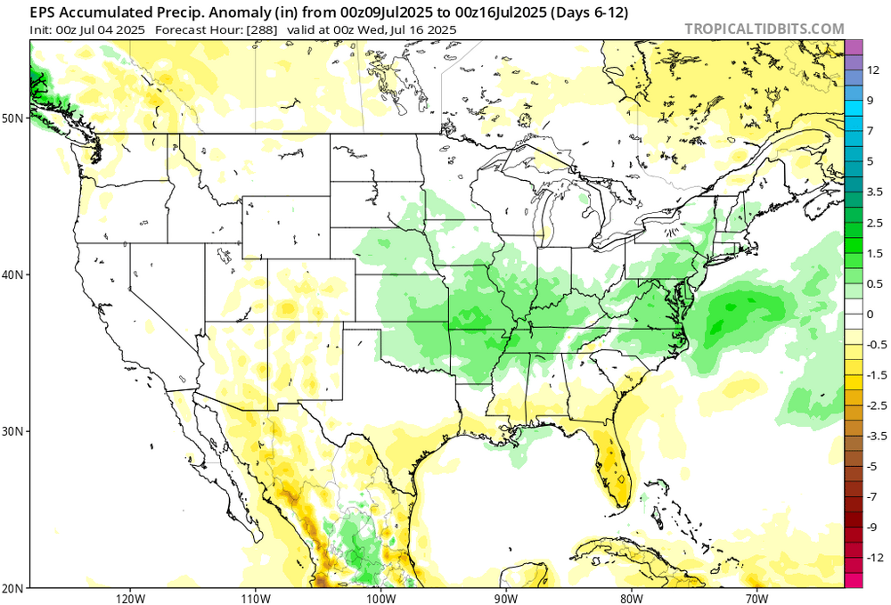
July 2025 Discussion-OBS - seasonable summer variability
bluewave replied to wdrag's topic in New York City Metro
Looks like the next warm up in mid-July will be another over the top one leaving room for moisture undercutting the ridge before then.
-
Steamy Independence Day in the Twin Cities. 88/70 at 11am. Water activities abound.
- Today
-
July 2025 Obs/Disco ... possible historic month for heat
moneypitmike replied to Typhoon Tip's topic in New England
Much mire wind and chop this morning. Fishing venture was shortlived -
-
The coastal areas of especially much of the Carolinas are likely going to be affected a good bit this weekend by Invest 92L, located ~100 miles E of N FL as it heads generally N. Recon will be in it early this afternoon. It’s possible that they’ll find that it’s already a TD. If so, TS Chantal may not be far behind. Conditions are moderately conducive to development. See the Tropical subforum for a dedicated thread for this.
-
Lovely day for a ride, or 2. Just as much as people are enjoying the nicer temps so are the horses. Have the younger Ms J down to exercise some ponies while hers is still on rest from an injury.
-

July 2025 Obs/Disco ... possible historic month for heat
ineedsnow replied to Typhoon Tip's topic in New England
you said it would be memorable so you kind of did -

July 2025 Obs/Disco ... possible historic month for heat
dendrite replied to Typhoon Tip's topic in New England
67.9/52 SCT A nice change of pace, COC day. -

July 2025 Discussion-OBS - seasonable summer variability
LoboLeader1 replied to wdrag's topic in New York City Metro
Spending the long July 4th holiday weekend with family & friends here in the Berks. Gorgeous outdoors, currently 71F under deep blue skies. Topped out at 92F yesterday back in HPN. -

Invest 92L--60% Two Day & 60% Seven Day Odds
GaWx replied to WxWatcher007's topic in Tropical Headquarters
Recon will take off at noon EDT and get into it during the early afternoon: SUSPECT AREA (OFF SOUTHEAST U.S. COAST) FLIGHT ONE - TEAL 71 A. 04/1800Z B. AFXXX 01BBA INVEST C. 04/1600Z D. 30.5N 79.5W E. 04/1730Z TO 04/2100Z F. SFC TO 10,000 FT G. LOW-LEVEL INVEST H. WRA ACTIVATION -
Perfection until all of the people showed up lol
-

July 2025 Discussion-OBS - seasonable summer variability
donsutherland1 replied to wdrag's topic in New York City Metro
2 consecutive days in 1948, not 3. -

Invest 92L--60% Two Day & 60% Seven Day Odds
WxWatcher007 replied to WxWatcher007's topic in Tropical Headquarters
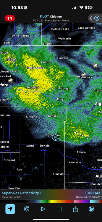
It’s hard to tell via radar but there looks like there’s a fairly well defined low level circulation.