All Activity
- Past hour
-
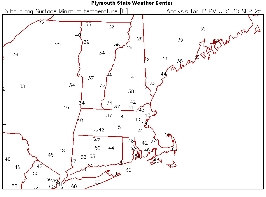
BDL maxima in the 4th week of September are low 70s. So now +5 is a "furnace"? First (light) frost this morning, low of 30. Our 28-year average for first frost is . . . today. (Though recent years have averaged later.) Will salvage cherry tomatoes and peppers today, as we'll likely dip into the 20s tonight. Covered the peppers last night as they're only 1-2 feet tall. All the remaining 'maters are 4-5 feet off the ground so safe from light frosts.
-
 Ragasa is looking mean this morning. I’m shocked Josh is chasing this, looks like it is traveling between the uprights in terms of splitting the populated islands in the area
 -
Beautiful morning here. Drier than I expected with this east wind. I blow the moisture off my cannabis plants with my leaf blower and their was hardly any dew this morning. It's going to be a beautiful day with these scattered clouds and breeze.
-
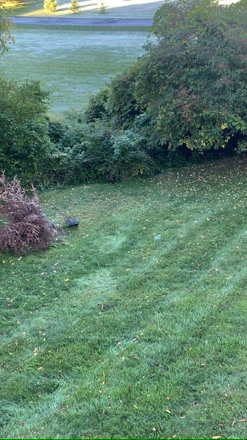
Patchy frost around here. On cars and any open areas, low spots. Frost out on the open lawn in this shot but not near the bushes.
-

2025 Atlantic Hurricane Season
WxWatcher007 replied to BarryStantonGBP's topic in Tropical Headquarters
I’ll take the over on no development after Gabby lol. You could see the tropical Atlantic being a dead zone again from a mile away—the real question is what happens when climo shifts to the Caribbean and homebrew regions. Those areas have been warmer with more instability and less shear all season. If their peak season is a bust, then we’ll be in bust territory. -

Central PA Summer 2025
Mount Joy Snowman replied to Voyager's topic in Upstate New York/Pennsylvania
Low of 59. Should be a glorious weekend. -

September 2025 OBS-Discussion centered NYC subforum
SACRUS replied to wdrag's topic in New York City Metro
65 / 44 clear . Sunny today cooler low - upper 70s in the warmest areas. A bit cooler tomorrow. Overall warmer and perhaps a period of rain as another low cuts off under the ridge between Tue - Sat next week. Will see where it does and which areas get some rains. -
Another season where many forecasters had the east coast above average chance with alot of storms. Just like winter outlooks, take the tropical outlooks with a grain of salt or maybe not do outlooks way far in advance.
- Today
-
Will my next measurable precip be snow?
-
September 20 Euro and GFS runs: no tropical development through October 6. lol at all the people saying the lid was gonna come off in the second half of September and early October. After Gabrielle that MDR is closed for the season, could still see a Caribbean/Gulf storm in October but this season will be a massive forecast bust.
-
I got 8" in that storm. I remember going down to town and it was just drizzling when I drove home gradually snow appeared and then about a quarter of a mile from the house everything was covered as I came around the last bend.
-
31.8° at 1P1. Didn’t expect them to do it the first night.
-
Mins
-
Streets were damp in Vienna when I woke up, but neither IAD nor DCA reported any rain.
-

September 2025 OBS-Discussion centered NYC subforum
LoboLeader1 replied to wdrag's topic in New York City Metro
43 here in the Berkshires this AM, no complaints here. Currently 60F back in HPN. -
42.5° Not too bad until I went outside and felt the breeze accompanying it.
-
34° for the low. Frost on the car tops. Looks like MVL is 32°
-
What, a 30 to 40% chance of showers doesn’t get your heart pumping?
-
Tuesday looks warm. The rest of the week looks meh
-
The Baltic Sea says hi. Record highs the last two days here. Heading to Stockholm tomorrow where it’ll be 20-30 degrees cooler thank goodness.
-
Thankfully stayed in the 50’s here
-
36.5F at a PWS a mile from me. My low was only 41, but that I think is my seasonal low. nice morning
-

September 2025 OBS-Discussion centered NYC subforum
bluewave replied to wdrag's topic in New York City Metro
Yeah, from the 60s to early 90s within a few inches of 25” was very common. There were a few seasons of near 30”+ and a few 20” and below. So a very balanced snowfall pattern during that stable colder era. The snowfall became all or nothing since 93-94. Most seasons have been over 30” or under 20” since then as the winters have continued to warm. The storm tracks remained cold enough to our south for many 30”+ seasons from 09-10 to 17-18. The warmer storm tracks since 18-19 have resulted in most seasons ending up with under 20” of snow. So it has been challenging to get a 30”+ season. Plus NYC hasn’t had a season near 25” since 12-13. So losing the higher end 30”+ seasons and continuing the decline in the near 25” seasons has resulted in the under 20” season becoming most common. NYC snowfall seasons near 25” 12-13….26.1” 08-09…27.6” 92-93…24.5” 90-91….24.9” 86-87….23.1” 84-85….24.1” 83-84….25.4” 82-83…..27.2” 81-82……24.6” 78-79…..29.4” 76-77…..24.5” 73-74…..23.5” 71-72…..22.9” 69-70….25.6” 64-65….24.4” -
-
Looks fairly warm right thru Helloween .


.thumb.png.4150b06c63a21f61052e47a612bf1818.png)


