All Activity
- Past hour
-
 34 F for a low at Barre Falls MA 7/1/1988. Same time MWN had 4" of snow for it most snow so late.
 -
 Dewy this AM. 68F currently. A full 16F higher than 24hr ago.
 -
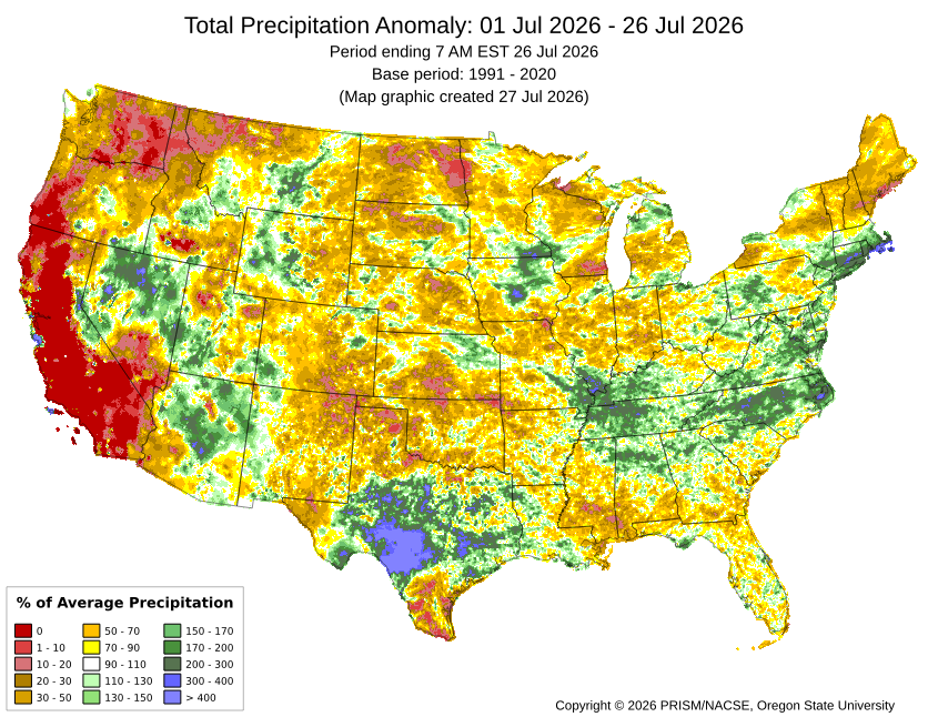
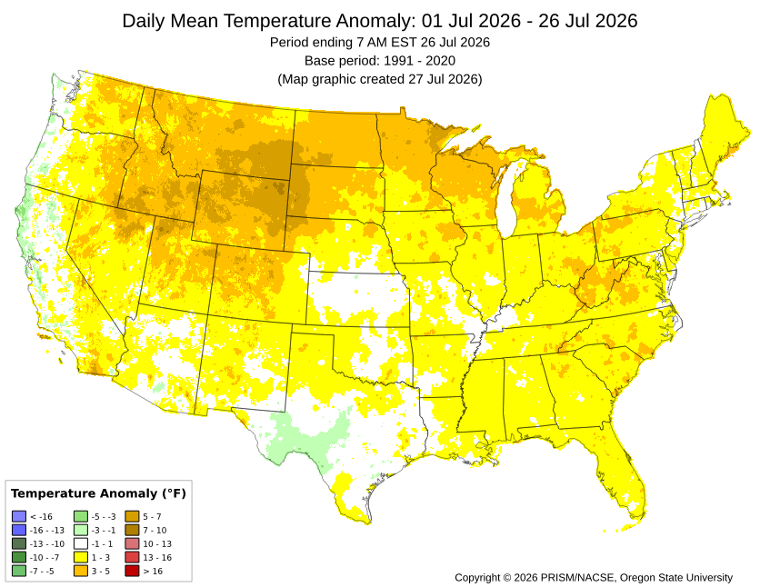
Our area will finish July much wetter than much of the CONUS which has been experiencing record heat and drought.
-
"Ever - in our life" Whose life? That is highly variable dependent on the person! Meaningless w/ context or standardization. Slicing and dicing down stats per day for any location you can find that has a record is bottomless pit. Always tons of stats like this, and when you consider how many wx parameters we have records for, and all the locations? Most of it is minutia or meaningless as to sensible wx impact, and yet the "race to the bottom" for content has resulted in this drivel.
-
 Somebody's all-in..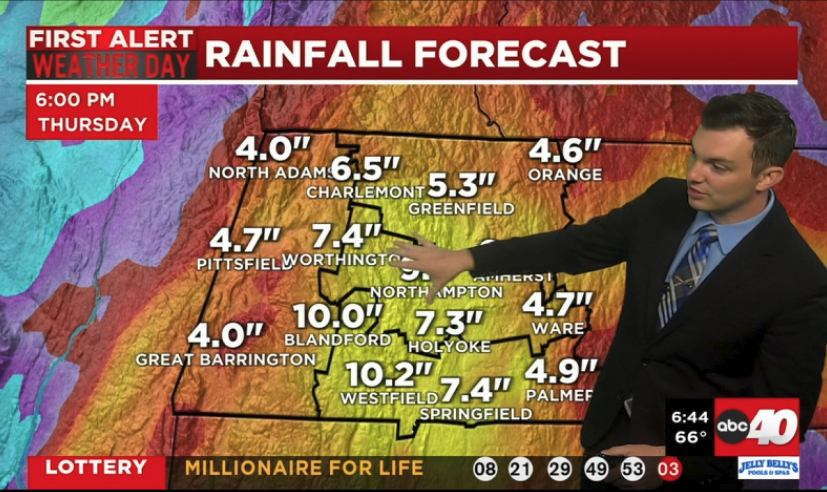
-
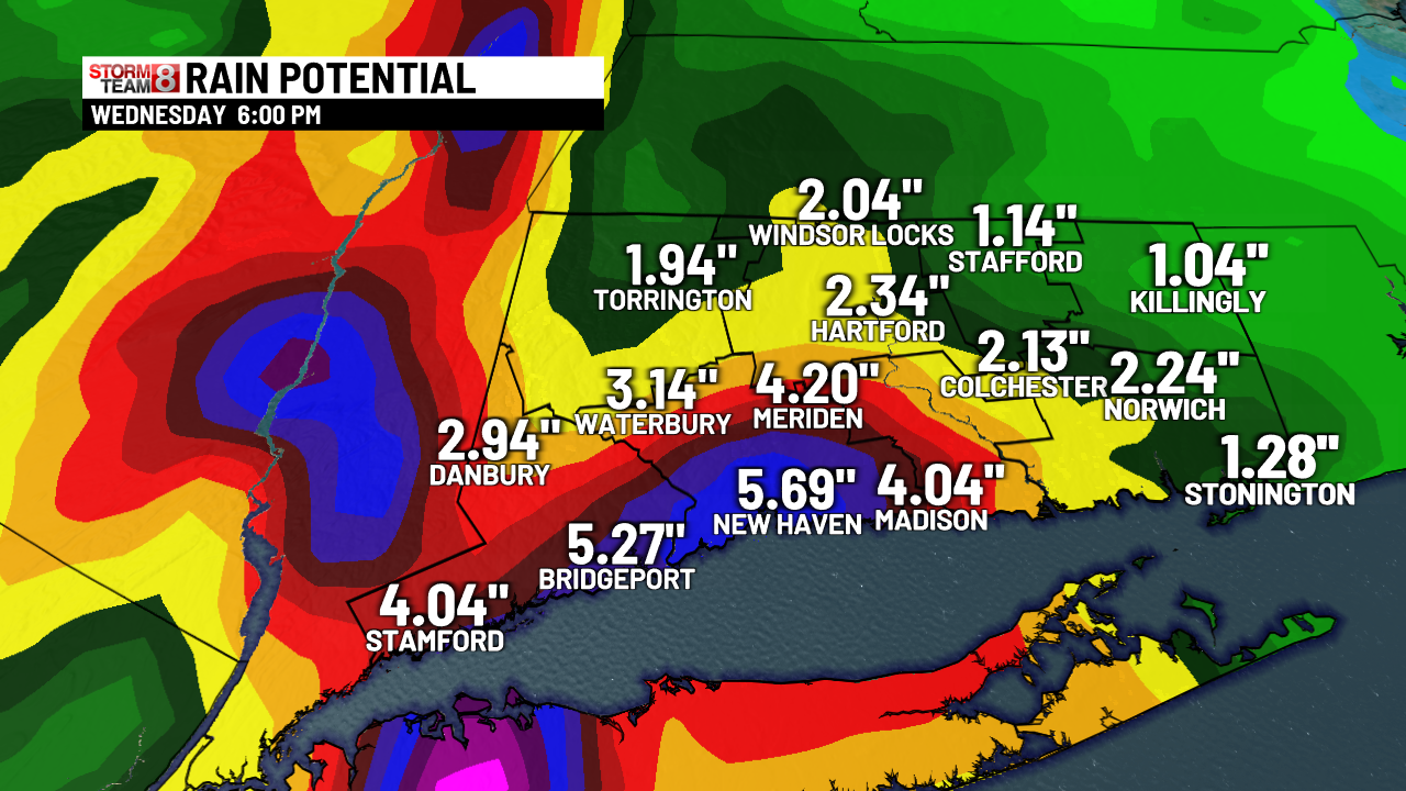
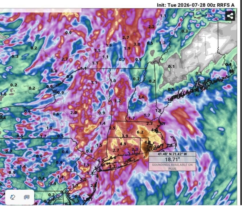
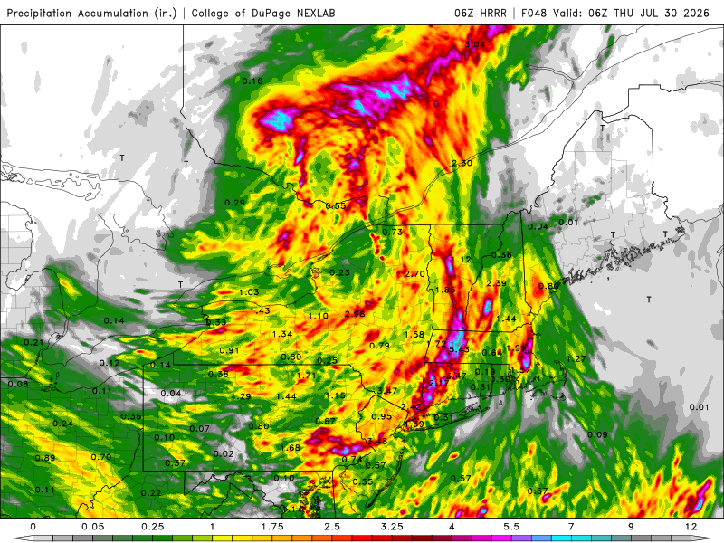
What about the 6.5" for Weymouth the HRRR has? Is that a garbage model as well?
-
Yes once again, duration. 6" in 48 hr is *not* the same as 6" in 6 hr! And w/ areas still w/ deficits, it mitigates things. Wrn and srn CT do has more of flood risk this time tho.
-
 Atmosphere certainly feels loaded.
 -
Similar totals and placement as the early July Rainer?
-

2026-2027 Super El Nino
bluewave replied to Stormchaserchuck1's topic in Weather Forecasting and Discussion
Just saying it’s going to be positive isn’t much of a stretch. But my examples of 2015-2016 and 2023-2024 both featured positive +PNA patterns. The magnitude and character of the positive is the question here which is a function of where the main Nino ridge and Aleutian trough complex becomes established. Plus we have the difference between the CPC PNA and the 500 mb PNA at times. Sometimes we get bootleg +PNA patterns like in January 2023 with a deep trough underneath the Canadian ridge out West which many consider a -PNA. We may have to be patient before getting something more closely resembling an El Niño pattern across the mid-latitudes of the Northern Hemisphere. -

Central PA Summer 2026 Discussion/Obs Thread
mahantango#1 replied to Voyager's topic in Upstate New York/Pennsylvania
.22 rain from a thunderstorm at around after 3am - Today
-
 Frcst less than 1". Shocking Sent from my SM-S921U using Tapatalk
 -
Hopefully we see some big storms today. After today we have several days of beautiful weather for August with highs in the 70s and lows in the 50s.
-

Central PA Summer 2026 Discussion/Obs Thread
pawatch replied to Voyager's topic in Upstate New York/Pennsylvania
Picked up over an 1” of rain this morning and still light rain. Also looks like we will have more rain later on today. Much Needed! -
Central PA Summer 2026 Discussion/Obs Thread
mahantango#1 replied to Voyager's topic in Upstate New York/Pennsylvania
Hazardous Weather Outlook National Weather Service State College PA 358 AM EDT Tue Jul 28 2026 PAZ004>006-010>012-017>019-024>028-033>037-041-042-045-046-049>053- 056-290800- Warren-McKean-Potter-Elk-Cameron-Northern Clinton-Clearfield- Northern Centre-Southern Centre-Cambria-Blair-Huntingdon-Mifflin- Juniata-Somerset-Bedford-Fulton-Franklin-Tioga-Northern Lycoming- Sullivan-Southern Clinton-Southern Lycoming-Union-Snyder-Montour- Northumberland-Columbia-Perry- 358 AM EDT Tue Jul 28 2026 This Hazardous Weather Outlook is for central Pennsylvania. .DAY ONE...Today and tonight. Scattered strong to severe thunderstorms, capable of damaging wind gusts and localized heavy rainfall of 1 to 2 inches per hour are possible today. -
Central PA Summer 2026 Discussion/Obs Thread
mahantango#1 replied to Voyager's topic in Upstate New York/Pennsylvania
Flood Watch National Weather Service State College PA 234 AM EDT Tue Jul 28 2026 PAZ057>059-063>066-290600- /O.NEW.KCTP.FA.A.0009.260728T0634Z-260729T0600Z/ /00000.0.ER.000000T0000Z.000000T0000Z.000000T0000Z.OO/ Dauphin-Schuylkill-Lebanon-Cumberland-Adams-York-Lancaster- Including the cities of Lancaster, Pottsville, Hershey, Gettysburg, Carlisle, York, Harrisburg, and Lebanon 234 AM EDT Tue Jul 28 2026 ...FLOOD WATCH IN EFFECT THROUGH LATE TONIGHT... * WHAT...Flash flooding caused by excessive rainfall is possible. * WHERE...A portion of central Pennsylvania, including the following counties, Adams, Cumberland, Dauphin, Lancaster, Lebanon, Schuylkill and York. * WHEN...Through late tonight. * IMPACTS...Excessive runoff may result in flooding of rivers, creeks, streams, and other low-lying and flood-prone locations. * ADDITIONAL DETAILS... - Multiple rounds of slow-moving and occasionally training heavy showers and thunderstorms will produce rainfall rates of up to 2 inches per hour leading to rapid runoff into low lying areas and small streams and creeks. - http://www.weather.gov/safety/flood PRECAUTIONARY/PREPAREDNESS ACTIONS... You should monitor later forecasts and be prepared to take action should Flash Flood Warnings be issued. -
 Garbage model. Although I still like SW CT Jack and a secondary one out east. Models did seem to back off a bit in wrn CT but it could easily come back so no need to knee jerk.
 -
-

2026-2027 Super El Nino
snowman19 replied to Stormchaserchuck1's topic in Weather Forecasting and Discussion
Incredibly impressive sea level anomalies/thermocline: -

Chester County PA - Analytical Battle of Actual vs. Altered Climate Data
chubbs replied to ChescoWx's topic in Climate Change
A good first step in using the raw data to identify station changes, with several station changes identified. What's missing are most of the station changes in Chester County. A couple of issues cause station changes to be missed: 1) It appears that only station moves and TOB changes described in NCDC documentation were investigated. There are two problems: NCDC documentation is incomplete and there are many other causes of station changes besides moves and TOB. 2) The common weather signal across stations is not identified. Having this signal facilitates the identification of station changes. and 3) Stations outside of Chester County are not used. Comments 2 and 3 work together. It easier to identify the common weather signal with more stations. The fact that many station changes are missed causes station comparison to break down. In summary the analysis is much less thorough than NCEI's A couple of comments on write-up itself. First like most AI its very wordy and wishy-washy. Too long to review carefully in detail. More importantly, there are no charts or quantification of any kind. Impossible to verify or compare to other results without hard numbers. -
Scott's favorite model does this (00z RRFS)!!! Aug 1955 Diane totals! But the 06z HRRR has almost 7" for Weymouth!
-
00z HRRR was good for big storm coverage in the DC Metro. 06z has backed off somewhat. 00z was putting it all in one big hit 3-7pm. 06z has sct storms in the area around 5pm, then good coverage e-cntrl and sern VA, then a second decent area coming from the PA border spreading SE 8pm-midnight. 00Z RRFS crushes DC metro at 5pm. 06z was a little less impressive but still solid. It does have the best storms in the RIC area. The MCS that moves from OH overnight to WV and wrn VA by noon appears to weaken enough and far enough away, so by peak heating, we should be ok in the much of the DMV. The best winds at 500 and 250 are S of the DC Metro, so I see why 5% tor risk is in sern VA. The NAM has excellent 925 and 850 winds in the DC Metro w/ nice curved hodographs, but the RRFS is less impressive and the GFS/ECWMF as well. Again, best winds fields are S and SE closer to the NC border.
- 1,499 replies
-
- 1
-

-
- severe
- thunderstorms
- (and 7 more)
-
In SPC's defense, they did have 2% tor risk for the area, and there was only one tor in WI. And at an atypical time of day, before noon CDT! Intense tornadoes in the morning are rather uncommon. It was not synoptically-evident event, but you do not need that for a significant tornado to occur. Sometimes it all works out on a very local scale. Storms deviate more to the right, ride along a warm front/boundary, storm mergers, etc. that can quickly escalate the situation and give you a high-end tornado event. Case in point - 5/25/2016 ern KS. Large area of sight risk and 2% tor area. A long-tracked EF4 occurred at Chapman KS. It is the #1 tornado chase for many chasers who were on it due to its slow movement, visibility, and structure. It avoided populated areas and no fatalities or injures, so it did not get much attention. That supercell that produced it was it for the state that day. See here: https://www.weather.gov/top/longtracktornadohitsnorthcentralks Plainfield IL in Aug 1990 and Jarrell TX in May 1997 are two other classic examples. 8/24/2016, 22 tors in IN/OH in a small cluster, and quite a surprise! https://www.spc.noaa.gov/climo/reports/160824_rpts.html And then we have 6/5/2024 here, 2% tor risk, and we ended up w/ 13 tors! That caught many by surprise. Warm fronts can be sneaky! Isolated intense tornadoes or local outbreaks can occur at times when it does not look impressive overall synoptically or even on the mesoscale hours before the event. It is not common, but law of averages and large numbers guarantees this will happen every so often.
-
I appreciate you input and response! My point is that 102 there is not the same as 102 in New England b/c the mean temps in the summer are significantly higher in this part of the county, so they are more used to 100 deg temps, so not as impactful net-net. It all relative to the normal climate. 102 in MLS is like 95 in BOS (dry bulb temp). Also, when they hit 102 on 7/26, dew points were in the mid 30s, so that gave a max heat index of 96, so that's a lot closer to their avg high, and this from a human impact standpoint, is that not better? But the media ignores this. Heat index is only mentioned when it is higher than the air temp. MLS POR is 1937 to present, at least for continuous records for monthly averages, so that removes a significant part of the very hot 1930s as to reference the hottest Julys, so although it has hot periods in recent decades, it is not likely as impressive as it seems given the POR. Yes it is still hot, but we need to adjust for climate of the location and the dew points present. It needs to be scaled. Again, going back to the E Coast media bias, they do not take this into account when reporting. They think 90 is "hot" everywhere. I've seen before, "oh it was so hot in DFW today w/ high of 95!", and their normal high in July is 97. See the problem here? The have no context or perspective. Facts are meaningless w/o context. To them it is all just one "furnace" that will end things.