All Activity
- Past hour
-
"Don’t do it" 2026 Blizzard obs, updates and pictures.
acoolerclimate replied to Ginx snewx's topic in New England
My back yard is fairly open, as well as the driveway, but there are a lot of trees. My sister on the Northeast side of N Prov, says she measured around 30 inches. I was just in a bad spot, I guess. -

"Don’t do it" 2026 Blizzard obs, updates and pictures.
dendrite replied to Ginx snewx's topic in New England
How do you even clear in 40+ mph winds without already fallen snow drifting or blowing back into your cleared area (essentially filling the bowl back in). I think I’d be tempted to measure this at the very end as well. Luckily I rarely get much wind with my snow. -

Winter cancelled/uncancelled banter 25/26
coastalplainsnowman replied to Rjay's topic in New York City Metro
Heard that during the storm too, but just assumed it was snowman19's tears. -
Who said that?
-
Colder than predicted today. Only reached 36 so far but nicer for a walk than yesterday felt.
-
I'm in that area frequently for different sports. Football, tennis, basketball, baseball and softball. Campbell County is in the same district as Halls.
-
you could even hear dripping sounds right after the storm ended
-

Clipper Fires In Wednesday Feb 25 Disco/ Obs
WxWatcher007 replied to Damage In Tolland's topic in New England
Helps to know what you want in life and pursue it lol All these years of talking about it maybe my wife subconsciously endorsed it when she applied for a new job. She loves the cold but hates the snow. -
Wind took care of a a lot and the sun is doing its thing helping! Something to be grateful for, don’t want that on roofs, especially if more snow falls. Luckily we’re at that time of year where it typically doesn’t last too long - best of both worlds.
-

Clipper Fires In Wednesday Feb 25 Disco/ Obs
Brian5671 replied to Damage In Tolland's topic in New England
perfect for more school closures! LOL -
deflect deflect defect
-
I don't know how to answer this in a simple way so bear with me. The A/B thing is overly simplistic and becomes complicated when you apply the more messy but real parameters of storms. Originally Miller only had his two A/B types but they have since added a ton more to try to resolve the complexity. Originally type A was a gulf wave that rode up the east coast without any transfer. B was a west to east system that jumped to the coast and redeveloped. However, this gets messy because most gulf waves that impact up here start out with a low up west of the apps and then redevelops to the east. Is this A/B? Frankly all storms "jump". Storms don't move. The low pressure continually reforms along the path of best height falls. We say convective feedback error all the time, but convection actually can "pull" a low off its path for a short time due to the meso height falls created. So yes some storms have a more continual path than others but they all jump to some degree, making these classifications overly simplistic. Then you get into phasing. Was it a pure STJ wave moving west to east that simply jumped to the coast or was there some weaker wave that phased with a northern stream SW? How does that impact the definition? What is important to the DC/Baltimore area is not so much "did the storm redevelop or jump" but where the jump happens and how mature the system is and its moisture source. The problem here is the main energy for the storm was a northern stream wave diving southeast that bombed and phased with a very very very weak pacific wave that split off and ejected from the retrograding trough out west. There was not a good moisture feed with the original pacific mid latitude wave and so the system had very little going on until it was captured and phased with the more energetic northern stream system diving in. This is not ideal for our area. Forget the A/B thing, what we need is a healthier wave with better moisture source coming at us from the west that jumps to the coast south of our latitude. Feb 2003. Feb 9 2010. We can do just fine with a transfer system if the wave has a good moisture source and is developing before it gets to our longitude/latitude. We will not if we are waiting on some northern stream wave to bomb out and capture and explode a weak wave just as it gets to us. That almost never works here. There was one in Feb 1996 that worked out...but that's about it. I can't think of any other examples where we had some NS system diving in from the NW waiting to bomb a virtually non existent wave just off our coast and we got into the CCB associated flush hit zone. It always ends up being NJ northeast thing. I called this a miller b because of the transfer and the fact the primary energy was that NS wave. It definitely was not a miller A and honestly I have not kept up with all the various additional definitions they've since added to try to better resolve this debate and I don't care to because it's silly. All storms jump. Ones that have to cross the mountains just have a more pronounced jump because they jump to where the coastal front is located. But some people have the wrong idea that the screw zone is because of this jump. It's because the storm went north of them. The mountains cause the screw zone because of the west wind creates downsloping to the south of the storm track. The appearance of the jump screwzone is more a function of the impact of the mountains. IF the track is south of your location you will usually do fine. But if it is north...yes a west wind once the low gets east of you will cut off the precip, but if the storm had not jumped and kept moving in that trajectory it would have been rain anyways, the mountains and the CAD associated is the only thing that saves places east of there in cases with a west track system...so you can't cherry pick one and ignore the other impact of those mountains. A storm tracking through the midwest going north of Winchester would have screwed them over regardless of a jump. The track is what's more important. Get that low into KY and jump it to off the VA capes and Winchester can do just fine. It tracks into OH/WV and jumps to off MD or north and...yea no good. Sorry I know this was more complicated than you wanted but it's not nearly as simple as the typical A/B debate makes it.
-
so not 22.5?
-
I've seen 72 over a foot of snow ... Granted it is rare
-

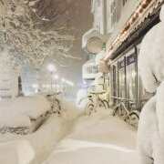
"Don’t do it" 2026 Blizzard obs, updates and pictures.
CCHurricane replied to Ginx snewx's topic in New England
Have been without power in Barnstable (Cape Cod) since 4AM yesterday. Cell service has been non-existent away from Route 28. Not being able to track radar yesterday was so frustrating. 21” here in Barnstable, but measuring in a blizzard is never easy. Can’t wait to chow down on +50 pages of event observations tonight.
-
What’s the deal with nearly no snow on anyone’s roof? Over 2’ and it seems to have disappeared fast
-
Or a wind-scoured valley, like our stake in the April 1982 blizzard at Fort Kent. 4/6: 24 0 T T 27" 4/7: 17 10 1.10" 15.0" 26" Wind NW 35G60, vis near zero 4/8: 23 13 0.14" 2.0" 25" Wind NW 20G40 I doubt there was much melting, but 15-20 feet either side of the stake there were 6-foot drifts.
-

February 2026 OBS & Discussion
donsutherland1 replied to Stormlover74's topic in New York City Metro
It would rank as the 15th warmest November on record. -

"Don’t do it" 2026 Blizzard obs, updates and pictures.
The 4 Seasons replied to Ginx snewx's topic in New England
Yeah fluff bombs like Jan 7th 2022 and Feb 7th 2021 with virtually no wind, short 6-10hr duration are the best for getting nice uniform snowfall totals. Events like these are a nightmare. And even worse 3 day events like Mar 2001. -

"Don’t do it" 2026 Blizzard obs, updates and pictures.
40/70 Benchmark replied to Ginx snewx's topic in New England
Exactly....agree. DT was breaking my balls on Facebook......dude always makes excuses when he busts..."The data changed"....love that one. Like...WTF is a forecast for if you can anticipate late trends and know when the data is BS?? He always used that excuse. -
It’s an A in my book. Prolonged cold since even December, snow on the ground consistently for at least a month plus, two 12+ inches snowstorms. For coastal CT that’s about all you could ask for. Having said that I’m over the cold. If it’s gonna be cold then at least snow. Otherwise let’s just torch lol
-
22 for Gloucester Been some kind of stretch.
-

"Don’t do it" 2026 Blizzard obs, updates and pictures.
amarshall replied to Ginx snewx's topic in New England
We’re not plowed, but I have power. Also have a big lifted truck for such occasions where I can drive around with an open beer can and get around wherever I want.[emoji23] . -

Clipper Fires In Wednesday Feb 25 Disco/ Obs
ORH_wxman replied to Damage In Tolland's topic in New England
These events are typically garbage east of the spine of ORH hills. Prob C-1” here…maybe 2” if lucky. -

Winter 2025-2026 Thoughts
Stormchaserchuck1 replied to donsutherland1's topic in Weather Forecasting and Discussion
I'm glad we don't have to talk about that anymore lol