All Activity
- Yesterday
-
We just need to steal a small and medium event before a decent pattern returns.
-

December 2025 regional war/obs/disco thread
H2Otown_WX replied to Torch Tiger's topic in New England
I'm just messin with you with the confused emoji. I guess time will tell. It doesn't look like an overly promising pattern but perhaps we end up just far enough north or south to benefit. Weird to see shortwaves getting shunted south on the GFS in what's supposed to be some epic warm pattern at least for the central US. -
That seems too much for our region. I really don't even see how plowed piles could last beyond the end of April around here, unless it was exceptionally cool. Otherwise, by May the 70's and higher dewpoints would eat any snow alive.
-

Winter 2025-26 Medium/Long Range Discussion
cyclone77 replied to michsnowfreak's topic in Lakes/Ohio Valley
I think torchartie did it if I remember right. -
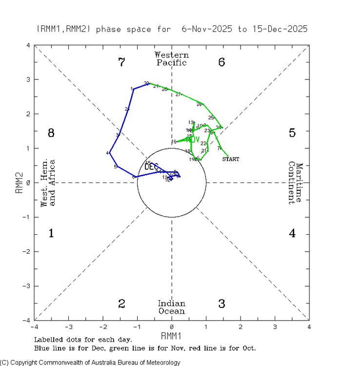
Ladies and gentlemen, can I have your attention, please? The results are in and we did it. The MJO went back into phase 8 on Dec 15th, the coldest day of the season to date! Let the celebrations begin! The weenies are gonna party like it’s Feb 1899!
-
i had tomato seedlings sprouting in the garden. it was so hot i wanted to put the ac on with a house full of guests. heck with that. at least we had some winter this year. hope spring eternal.
-

December 2025 regional war/obs/disco thread
WinterWolf replied to Torch Tiger's topic in New England
If you were 60 miles north, or 700 miles south(VA, NC, DE)..you’d have alot of snow the last few weeks. That’s the funny part. -
Tomorrow and Friday will be mild days with highs reaching or exceeding 50° in parts of the region. Friday will be the warmer day with highs in the 50s across much of the region. A soaking rain is likely tomorrow night and Friday. Much of the region could see a general 0.50"-1.50" of rain. Behind the storm, the weekend will turn somewhat cooler. No exceptionally cold or warm weather appears likely for the first week of astronomical winter. The probability that December 2025 will have a maximum monthly temperature below 60° has continued to increase. The last time that happened was in 2019 when the monthly high was 58°. If 2025 has a monthly high below 60°, that would be only the fifth such occurrence since 2000 (2003, 2004, 2005, and 2019 are the cases since 2000). The ENSO Region 1+2 anomaly was -0.3°C and the Region 3.4 anomaly was -0.7°C for the week centered around December 10. For the past six weeks, the ENSO Region 1+2 anomaly has averaged -0.33°C and the ENSO Region 3.4 anomaly has averaged -0.67°C. La Niña conditions will likely continue through at least mid-winter. The SOI was -4.26 today. The preliminary Arctic Oscillation (AO) was +2.532 today. Based on sensitivity analysis applied to the latest guidance, there is an implied near 99% probability that New York City will have a cooler than normal December (1991-2020 normal). December will likely finish with a mean temperature near 34.0° (5.1° below normal). Supplemental Information: The projected mean would be 3.4° below the 1981-2010 normal monthly value.
-
.thumb.png.4150b06c63a21f61052e47a612bf1818.png)
December 2025 regional war/obs/disco thread
HIPPYVALLEY replied to Torch Tiger's topic in New England
The cutter on Friday sucks, but at least the weather will be a little bit interesting that day. -
.thumb.png.4150b06c63a21f61052e47a612bf1818.png)
December 2025 regional war/obs/disco thread
HIPPYVALLEY replied to Torch Tiger's topic in New England
This has been one of the most boring “active patterns” ever and the fact that we have the cold air has been a bit maddening. -
I think the places to the NW and up into Northern Maine should hang on.
-
The climate has always been changing. Probably why we had shitty ass winters in the 80s and some amazing ones after... and before that. NO one can say this is permanent, and likely isn't. Pattern will continue to morph as it always has, it's the outcome and downstream changes we have no idea about.
-

December 2025 regional war/obs/disco thread
WinterWolf replied to Torch Tiger's topic in New England
For sure. Silly folks. -

December 2025 regional war/obs/disco thread
WinterWolf replied to Torch Tiger's topic in New England
We like that…let’s keep you guys and the county in the snow. -

December 2025 regional war/obs/disco thread
WinterWolf replied to Torch Tiger's topic in New England
We crushed it here for a couple decades…it was bound to change. Other parts of the country getting their turn the last 4-5 yrs. While we were pulling 12-16 inchers out of our ass Constantly, other parts of the country were baking, and drying out. It happens. It happened before. Just gotta roll with it.. it will change. But until it does, we take it on the chin. NNE just crushed it the last 3 weeks..best start in history perhaps.? And Virginia and Delaware and NC doing real well too…we stuck In between. -
18z GFS was pretty skimpy on the qpf for here Friday.
-
I'm a nutjob cold weather winter weenie but damn... How We Drive a Car at −71°C (−95°F) | Yakutia, Siberia
-
Lot of hyperbole amidst kernels of truth.
-
What
-
We had a snow squall warning issued in 2019 and it definitely verified here
-

Winter 2025-26 Medium/Long Range Discussion
IWXwx replied to michsnowfreak's topic in Lakes/Ohio Valley
Who was it in here that once had a snow making machine? There may have been two people. -
It is a permanent issue. With a record warm west pacific year after year, that supercharges the pacific jet and/or southern stream and nothing is ever able to phase properly. Back in the 2010s, there would be bowling balls traversing CONUS and anywhere east of the Rockies would do well. Aside from 2021, that has been absent for most of the country. 2020, 2023, and 2024 were very good out west thouhh, with 2023 and 2024 having record snows for Rockies through upper Midwest and Great Lakes (even 2020 and 2019 to some extent.) But the northeast has been the loser time and again, and that’ll continue for as long as the west pacific remains very warm. Climate change will only exacerbate this. Welcome to the new normal.
-

Saturday night/Sunday 12/13-12/14 Jawn
MGorse replied to Ralph Wiggum's topic in Philadelphia Region
Usually those old reports are removed from the PNS going forward and especially for the final one (we received something like 500 reports during and immediately following the storm!). There were some issues however with the software we use during the Sunday storm, plus there was a newer Meteorologist gathering the reports and issuing LSRs and PNSs. Also, thanks for the kind words in your second paragraph. We try our best but are certainly not perfect. -

December 2025 regional war/obs/disco thread
Damage In Tolland replied to Torch Tiger's topic in New England
There’s far too much cold from Siberia all the way into SE Canada to have us get warm. That’s very unlikely. The cold is going nowhere . Not to say no screamers but it’s not a warm pattern in the N tier -
Tracking anomalies and projected end of month ... _____________________________ DCA _NYC _BOS __ORD _ATL _IAH ___DEN _PHX _SEA _____ (anom 1-16) __________ -9.2 _ -8.7 _ -7.7 __-10.7 _-4.9 _-3.2 __+8.3 _ +5.1 _ +6.4 _____ (p anom 1-31) ________ -5.0 _ -4.5 _ -4.0 __-6.0 _-2.5 _-1.0 __+6.0 _ +3.5 _ +2.5 (17th) _ A more variable regime will cut into large negative anomalies in eastern and central regions. It will stay generally mild in the western regions but SEA will have a larger reversal as arctic air builds in for a while later in the month.


