All Activity
- Past hour
-
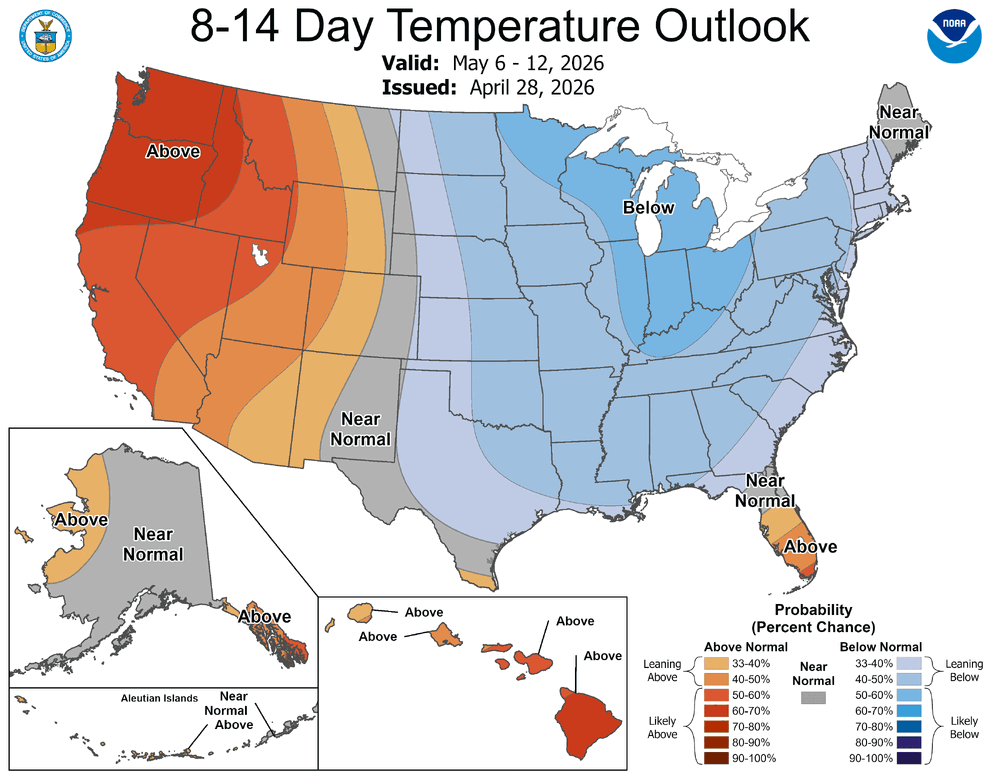
April is just about in the books, so we turn our attention to May flowers and the prospects of thunderstorms. CPC says cool and wet may be in order first.
-

Texas 2026 Discussion/Observations
Stx_Thunder replied to Stx_Thunder's topic in Central/Western States
Primary threat today around DFW still looks to be svr/large hail, once again. Significant Hail Index Parameter on special 19Z UA obs this afternoon is even higher than it was on Saturday evening's 0Z UA obs that was 3.4 At 4.0 this afternoon. Definitely high for that hail parameter, no doubt. I have not seen it go that high before in the state, as far as I can remember. -
Oak buds are starting to swell here. Things will probably slow down through the weekend. There's still a couple of freeze chances here Sun-Mon.
-
Take them apples-
-
Interesting. Now the Ravens have a third string QB. Why does he look like he is 35?
-

2026-2027 El Nino
snowman19 replied to Stormchaserchuck1's topic in Weather Forecasting and Discussion
-
Something like this?

-
Yep, finished mowing around 2:30. The weeds look better now.
-
Big pun hit ya with the big bun

-

2026 Mid-Atlantic Severe Storm General Discussion
George BM replied to Kmlwx's topic in Mid Atlantic
No it wasn't. That tornado occurred on September 24, 2001. Coming to think about it... it sure was something that we got two different significant/violent tornadoes in the area a little over 7 months apart. -
Not a player just Punny ?
-
And for the record, I’m just being punny. Please don’t indict me.
-
He's on mobile. Strolling the beach hand in hand with the former FBI Director.
-
If you use his numbers… 86.6” is 1.8” below normal. Normal being 88.4”.
-
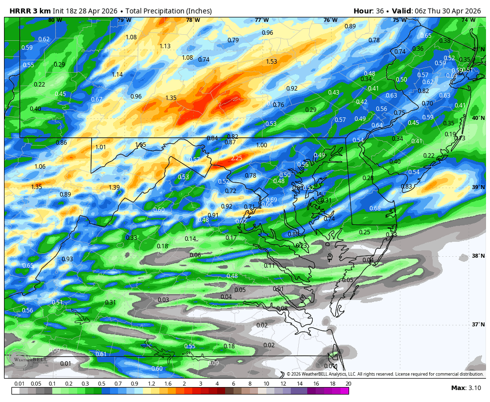
Mount Holly's graphic from this morning is still up, with a half to one inch for the entire forecast area. Their latest forecast for here is less than a tenth tomorrow, tenth to a quarter tomorrow night, less than a tenth Thursday. Another bust.
- Today
-
One thing seems certain- its not going to be hot anytime soon
-
86.47?
-
-
WB 18Z HRRR for Wed.

-

2026 Mid-Atlantic Severe Storm General Discussion
nw baltimore wx replied to Kmlwx's topic in Mid Atlantic
Was that the same day as the College Park tornado at UMCP? -
It's neat to watch this... That low in the ocean is clearly attempting to retrograde W at the same time this axis of schmutz is attempting to move E. https://weather.cod.edu/satrad/?parms=subregional-New_England-02-24-0-100-1&checked=map&colorbar=undefined
-

Central PA Spring 2026 Discussion/Obs Thread
Itstrainingtime replied to Voyager's topic in Upstate New York/Pennsylvania
It might be especially rough this week if we get enough rain tomorrow night. -
See my edited post just above…going by his numbers from ‘12-‘13.
-
This is the best we can muster in full sun today. The bane of the bay...
-
Updated discussion .KEY MESSAGE 2... An upper level low shifts east and will linger over eastern Canada, with broad troughing over the eastern US through the weekend. This pattern will lead to cool conditions, with a stretch of highs and lows 5 to 10 degrees below normal. Stuck with NBM temperatures for now, but trends will be monitored as there will be a few nights across the interior where frost may be possible. The offshore low that was mentioned in the previous forecast has shifted farther in the latest guidance, far enough to lower the potential for impacts to the area.
- 940 replies
-
- 1
-

-
- april showers bring may..
- rain
- (and 2 more)