All Activity
- Past hour
-
Y'all are gonna get walloped. Enjoy! Make a snowman.. or 19 of them.
-
one thing-if you end up near a band but not in it-you can get skunked from subsidence around the band.
-
https://dtwxrisk.medium.com/first-call-snow-map-blizzard-possible-for-nyc-long-island-southeast-25-of-new-england-06741b0b8185
-
Would not be surprised to see the NWS hoist blizzard warnings into PA tonight or early tomorrow.
-
Curious as well. Any Mets?
-

“Cory’s in NYC! Let’s HECS!” Feb. 22-24 Disco
Ginx snewx replied to TheSnowman's topic in New England
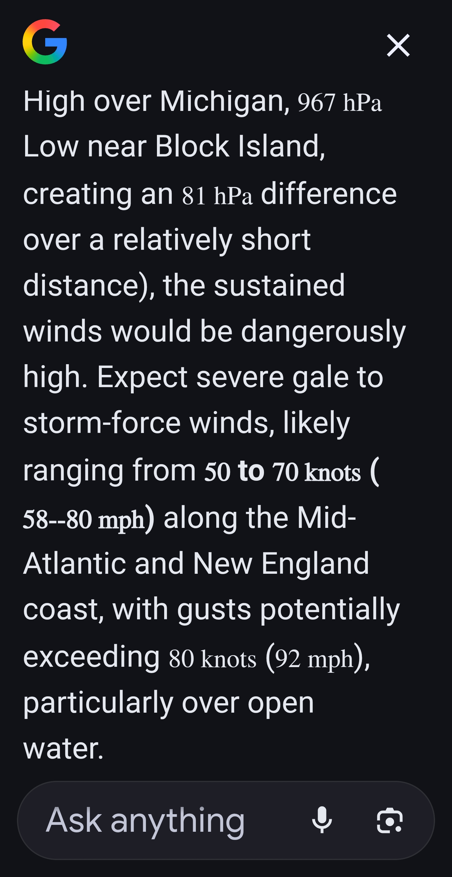
1048 vs 984 1049 vs 967 Same distance
-
must be the plastics?
-

Pittsburgh/Western PA WINTER ‘25/‘26
Mailman replied to Burghblizz's topic in Upstate New York/Pennsylvania
47% chance of 4" / 31% of 6", according to PBZ. So maybe a surprise for some? Didn't even realize I was under an advisory for 2-5". -

Richmond Metro/Hampton Roads Area Discussion
mikeeng92 replied to RIC Airport's topic in Mid Atlantic
Awesome disco from Wakefield. Leaves the door open for the positive bust: Given how much models have trended over the past 24 hours and lingering uncertainty with respect to how much snow will accumulate farther inland, have opted to hold off on Winter Weather Advisories for this forecast cycle. The EPS probs for >3" of snow has increased to 50% all the way to Richmond with lower (but nonzero) probs extending across most of the FA. Nearly all model guidance continues to show strong banding and heavy rates of 1- 2"+/hour developing Sun evening inland as the surface low rapidly deepens and the upper level system moves overhead. As such, there likely will be a quick transition from rain to heavy wet snow for most of the area late Sun afternoon into Sun evening as the band slowly pivots E. High snowfall rates can overcome warm and wet surface conditions and lead to rapid accumulation amidst otherwise marginal surface temps. Additionally, if rates are high enough, cooler air aloft will be pulled down to the surface, likely dropping temps to around freezing (as opposed to 33-34F). As such, we have essentially two possible solutions. The first is that rates are lighter and most areas struggle to accumulate more than 1". The other possible solution is that rates overperform and we quickly accumulate at least a few inches of snow with high-end Winter Weather Advisory to low- end Winter Storm Warning criteria snowfall. Either of these is possible (or something in the middle). Therefore, will wait for the 00z model guidance to see which of the two scenarios is more likely. In any case, at least Winter Weather Advisories are likely going to be needed for a large portion of the area. -
So what can go wrong with this storm for the tristate from a meteorological point of view .
-
its a tough crowd, but philly is tougher... i mean they threw snowballs at santa claus.....
-
kudos to you for these updates.
-

“Cory’s in NYC! Let’s HECS!” Feb. 22-24 Disco
Damage In Tolland replied to TheSnowman's topic in New England
Snowing here -

Central PA Winter 25/26 Discussion and Obs
GrandmasterB replied to MAG5035's topic in Upstate New York/Pennsylvania
ICON a hair stronger and further west. Low position is very close to the MD coast. -
Dear GFS, You still suck. You owed us one...or a hundred. Disrespectfully, The Wx Community
-
A sub 980 low on or close to the benchmark in mid-late February in NYC always delivers. Once we're talking about 18-24 inch snowstorms, 1888, 1978, 2006, 2016... they're all in the conversation.
-

The February 22-23 Late Season Miracle: JV Disco/Banter Thread
TSSN+ replied to bncho's topic in Mid Atlantic
Getting word they sending me home this evening. Thank goodness. But the communication in this hospital is awful. They told me a GI doc was going to come see me yesterday and they never did, then said today and they never did. Only one doctor stopped by this afternoon and didn’t give me much of a game plan. But nurse came in and said sounds like your going home. I’m like ok??? What’s the game plan here people. lol -

“Cory’s in NYC! Let’s HECS!” Feb. 22-24 Disco
40/70 Benchmark replied to TheSnowman's topic in New England
I had you 5-10" and KCON right near the line of 5-10"/10-15". -
https://epawaweather.com/weather-alerts/
-
wow. nasty. kissing the goal posts (benchmark)
-
Question I’ll pose, albeit may be too early: does this have some hallmarks of the granddaddies of the past, some that some of us have been alive for, some that we’ve only heard about? My initial thoughts: March 1888 February 1978 January 1996 Of course there are others, but those three are some inner-circle, first ballot HoFers. Thanks. I’ll hang up and listen. .
-
Flights out for 00z recon! Let’s bring it home
-
Just got in from snowblowing my own property, WMUR TV has Nashua 8-12" did this dive more south since early am?
-
Bruh look at this mess. That is straight trolling (mind you I'm in Baltimore).

-

2/22-23 "There's no way..." Storm Part 2
IUsedToHateCold replied to Maestrobjwa's topic in Mid Atlantic
This is one of the rare times the water is helping to keep us cooler out here. If you look at the Weather Underground map of stations you see a 5 degree difference near the water. I was out most of the day but I was gonna say we needed the 18z NAM to deliver, and it definitely did. I'm going high end all in. 20 inches for the Nat 20.