All Activity
- Past hour
-
And who did Emery Jones come in to replace??? Vorhees!! Cant make this shit up. FIRE HARBAUGH.
-

Nov 28-30th Post Turkey Day Wintry Potential
sbnwx85 replied to Chicago Storm's topic in Lakes/Ohio Valley
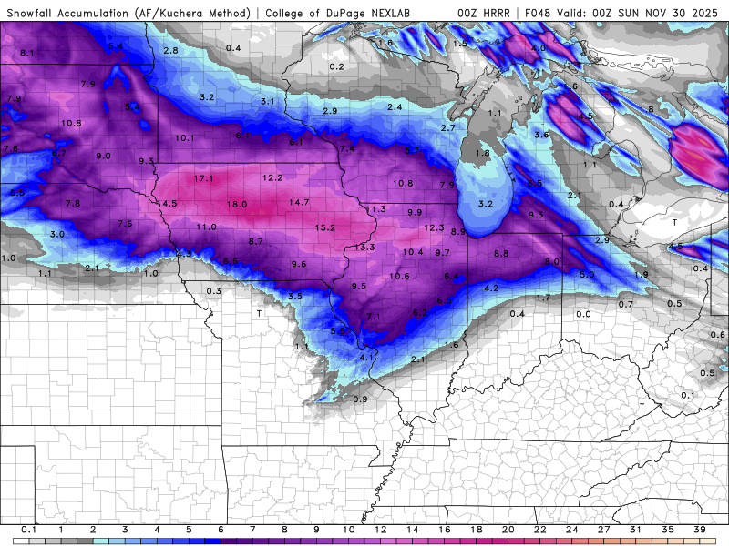
Last hour of the HRRR plus kuchera amounts. It’s making me a little nervous seeing how far north that warm air is budging in… and a potential dry slot.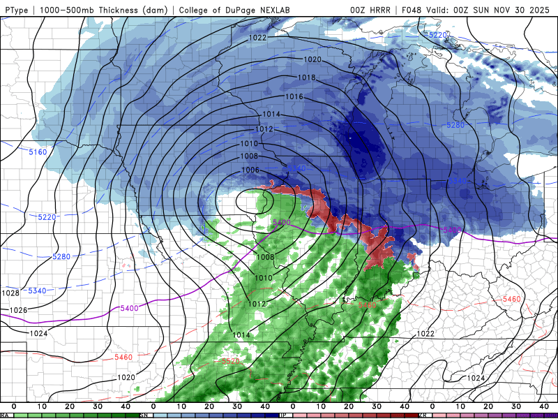
-

December 2025 regional war/obs/disco thread
Baroclinic Zone replied to Torch Tiger's topic in New England
Foxborough IS a better geographical spot than Taunton. Nothing to debate. -
You are 15 miles southeast of me, in my opinion that’s going to matter for this storm. I could be wrong, but im betting on me getting a minor snow event and you getting all rain.
-
A great day indeed, hopefully you and yours had a wonderful day too.
-
Notice how Faalele got pushed into him...Lamar uses one hand to try and bounce off...strip sack. So that was 90% on the guard
-
He definitely was! I remember him calling for the early December snow in 2010 when it wasn't on anyways radar that afternoon. We received about 4 inches of snow
-
George hitting the eggnog.
-
And look which lineman got pushed into Lamar and helped make that fumble? Smh
-
Who's this?
-
WTH was that by Lamar?
-

December 2025 regional war/obs/disco thread
TauntonBlizzard2013 replied to Torch Tiger's topic in New England
LOL, no you are not. Good grief. We’ll revisit this next week -
December 2025 regional war/obs/disco thread
TauntonBlizzard2013 replied to Torch Tiger's topic in New England
He’s in a “much better spot” literally like 7 miles from here. lol. This place makes me want to put my head through Sheetrock sometimes -
.thumb.png.4150b06c63a21f61052e47a612bf1818.png)
December 2025 regional war/obs/disco thread
HIPPYVALLEY replied to Torch Tiger's topic in New England
The past few winters have taken a toll on weenies. This year doesn’t produce, we’ll be getting into Lord of the Flies type situation. -

Nov 28-30th Post Turkey Day Wintry Potential
Stebo replied to Chicago Storm's topic in Lakes/Ohio Valley
Looking good time to lock it in -
Def some more hugged members in there. Baby steps.
-
Foxborough trolling Taunton over location was not on my bingo card
-
December 2025 regional war/obs/disco thread
HIPPYVALLEY replied to Torch Tiger's topic in New England
We missed you Bob! -

Nov 28-30th Post Turkey Day Wintry Potential
andyhb replied to Chicago Storm's topic in Lakes/Ohio Valley
HRRR continues to be very impressive, albeit likely overdone. Verbatim would likely mean some pockets of 12-18" over IA and N IL/S WI. -

Nov 28-30th Post Turkey Day Wintry Potential
frostfern replied to Chicago Storm's topic in Lakes/Ohio Valley
I don’t know what kind of ratios this is. I prefer to look at 10:1 and bump it up a little in my head. It’s hard to get 15:1 or better this time of year without lake enhancement. WAA snow tends to be somewhat denser, at least in my area with E wind off the land. -
I hope everyone had a nice time celebrating today
-
I am in a much better spot than you are for this storm. I don’t think I am getting a lot, but nothing is unlikely.
-

Best Mid-Atlantic winter storm of the last 50 years
gopper replied to PrinceFrederickWx's topic in Mid Atlantic
Ditto this! I was 11 but my experience was the same as yours. I remember waking up around 4ish and was in absolute awe at how hard it was snowing where I lived in Baltimore. I went from window to window not really believing what I was seeing. It was also special that the rest of the family was still asleep...felt like it was a special gift just for me! Although I have seen a couple of storms with more overall accumulation, there was no replacing seeing the rates that PD1 gave early that morning! Instant imprint on my brain that led to this sick obsession that I share with many of you on this board. I'm glad that I am now old enough that I can enjoy each and every event without all of the ups and downs of model mania. -

November 2025 general discussions and probable topic derailings ...
ineedsnow replied to Typhoon Tip's topic in New England
0z HRRR whitens the ground tomorrow for some -
We absolutely want a good source region for surface cold but if the mid levels are torched/ruined by a too late low transfer to the coast, the surface doesn’t matter unless you’re into a lot of sleet or ZR. This setup seems like there’s enough cold air to the north at the surface that we’re more interested in when the low transfers to the coast and surface wind direction. A transfer too late keeps winds onshore and torches our surface, or torches the mid levels by a bad 700/850 low track to our west. You also really want to watch the mid level low evolution in a storm like this and where the 700/850 lows track.


