All Activity
- Past hour
-
The increase in development in Western Brooklyn and Queens last 20 years in relation totality of the urban footprint and UHI warming temperatures is still very small compared the the increasing CO2 forcing,. But it’s a big difference in terms of neighborhood traffic and aesthetics. It’s also pushing the coast of living through the roof due to skyrocketing rents and condo prices and continued gentrification.
-

December 2025 regional war/obs/disco thread
brooklynwx99 replied to Torch Tiger's topic in New England
the GEFS is just going to do what the GFS does at this range -

Central PA Winter 25/26 Discussion and Obs
Itstrainingtime replied to MAG5035's topic in Upstate New York/Pennsylvania
I would be thrilled with a 2-4" advisory event with a couple of cold days to follow. December snow is my favorite. -

December 2025 regional war/obs/disco thread
TauntonBlizzard2013 replied to Torch Tiger's topic in New England
It’s definitely nice to see a solid euro run, however, the gfs and icon along with the gefs being a whiff should give everyone pause, especially given what we’ve seen in this flow -

2025-2026 Fall/Winter Mountain Thread
Daniel Boone replied to Buckethead's topic in Southeastern States
Yeah. I can remember back in my Day's of the Criteria being that plus Temps below 20 F. -

Central PA Winter 25/26 Discussion and Obs
Blizzard of 93 replied to MAG5035's topic in Upstate New York/Pennsylvania
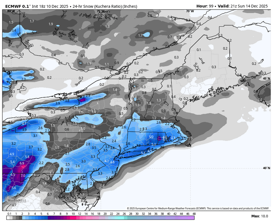
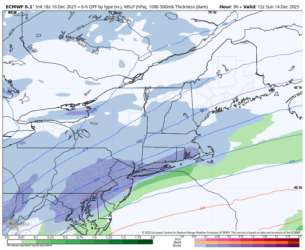
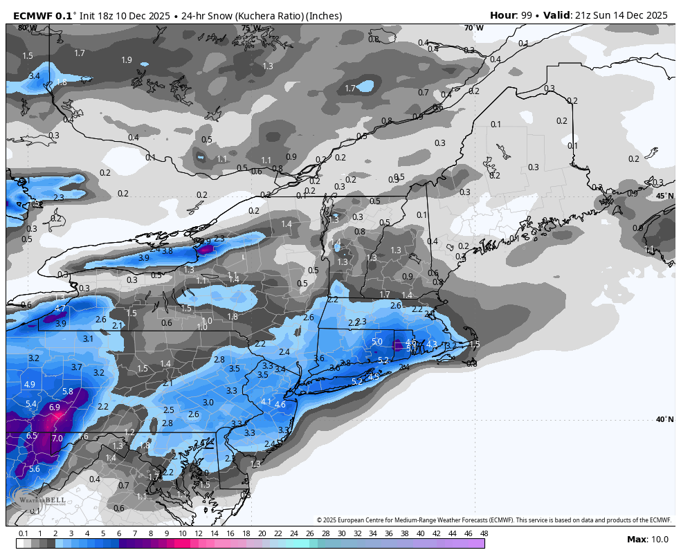
Good 18z Euro run for the LSV for the early Sunday chance.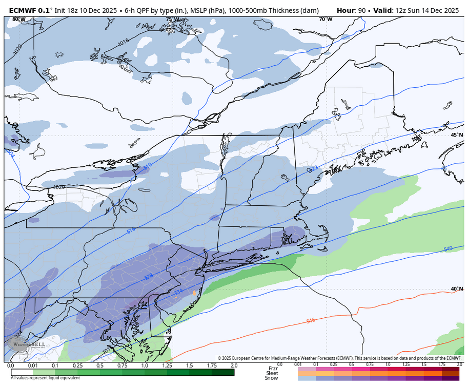
-
Pushing 2”. Over a foot on the season now.
-

December 2025 regional war/obs/disco thread
RUNNAWAYICEBERG replied to Torch Tiger's topic in New England
We don't know yet. -
January 2017 was the longest freeze free period in any DC winter.
-

December 2025 regional war/obs/disco thread
40/70 Benchmark replied to Torch Tiger's topic in New England
I think this is reasonable, but could see higher. -
26.7° -SN/SN Up to 1.8” Decent rates and growth IMG_7245.mov
-
I agree between the 1890s and 1960s NYC expanded a lot and it keeps getting bigger. Maybe it isn't substantial but I wouldn't call all that building of skyscrapers a drop in the bucket. What makes me even bring it up is when I cross the Throgs Neck bridge and look toward the city I see the Manhattan skyline but then to the south you see the Brooklyn and Queens skyline and it looks like another large city was built.
-
Some modeling shows possible snow showers or squalls tomorrow. Something to keep an eye on... despite the lack of "snowstorms" so far this year, I've seen snow a lot more to date than the past few years. The vibe feels different.
-

December 2025 regional war/obs/disco thread
Typhoon Tip replied to Torch Tiger's topic in New England
as we close in on 14th ... just be leery of the NAM NW bias/amplitude issues beyond 36 hours -
Interesting micro-climate observation out my way; as I climbed in elevation north of 287/78 interchange on 206, it flipped to heavy snow about 1/4 mile south of my home. 1/2” on all surfaces, even pavements.
-
Euro brings Barney in Sunday evening. Add a bit of snow and someone gets single digits I bet.
-
starting to flip over to snow here
-
Better for us. Instead of being in the 1" area just west of the 1.5" line, we're un the 2" area just shy by feet of the 2.5" line.
.thumb.png.dd7639f8b6d14841703ff9ee6546e05c.png)
-
The windshield wiper effect is strong with this one. We are only 4 days out and I have no idea what is going to happen. We just don’t know……
-
26/25°F, 0.50" of snow before the flip to FRZRN.
-
Turned into a pretty snowy evening for NW burbs especially with some elevation. As already mentioned, the NAM, GFS, and ECM did pretty good along the southern periphery of snow. HRRR and RGEM not so much - too warm. Apart from the ECM and ECM-AI (haven't seen?), 18z wasn't great for this weekend's potential event.
-
Kudos to Vernon Township DPW. They are in my neighborhood now. 2nd time plowing and salting. Roads are perfect.
-
Wantage NJ (this southern part at 740' MSL). 1.8" final-wet clingy snow. Less on driveway and virtually none on paved roads now... temp rising to 32.4F.
-
Can’t wait to see the pics from this group. It’s about to absolutely crank.
-
Long Island


.png.42d334aec05316bd9fafafbd4e58fe47.png)


