All Activity
- Past hour
-
This thing is gonna go viral.
-
Nice storm, GBM! Need to find a way to get this puppy to slow down and get captured! Love to see you guys end up with a wet nine feet of fresh snow!
-
Regarding the MDR lemon: A tropical wave is expected to move off the coast of Africa over the next day or two. Thereafter, this wave is forecast to interact with another disturbance in the eastern tropical Atlantic, and some slow development of the combined feature is possible as the system moves westward to west-northwestward at 15 to 20 mph. * Formation chance through 48 hours...low...near 0 percent. * Formation chance through 7 days...low...30 percent. Forecaster Jelsema ——————— I didn’t post it. But the 12Z UKMET had a TC form from this at 162 hours and it was already recurving/moving NW to 23.7N, 57.2W at 168. The new UKMET (0Z) forms it 18 hours earlier and it moves WNW instead of NW meaning it ends up much further S than the 12Z run had it at the end of the run (~150 miles NE of the Leewards): NEW TROPICAL CYCLONE FORECAST TO DEVELOP AFTER 132 HOURS FORECAST POSITION AT T+132 : 15.7N 53.2W LEAD CENTRAL MAXIMUM WIND VERIFYING TIME TIME POSITION PRESSURE (MB) SPEED (KNOTS) -------------- ---- -------- ------------- ------------- 1200UTC 08.10.2025 132 15.7N 53.2W 1009 40 0000UTC 09.10.2025 144 17.5N 56.5W 1009 39 1200UTC 09.10.2025 156 18.8N 59.3W 1009 34 0000UTC 10.10.2025 168 19.7N 61.4W 1008 31
-
This is hyperbole. Why? -DCA from 2000-01 through 2024-25 averaged 13”. Even if they were to have NO snow the next 5 winters, which of course is practically impossible since they’ve yet to have even one with 0”, they’d still average ~11” for 2001-30. -DCA averaged 10.6” 2010-11 through 2024-25. If they were to have no snow the next 15 winters (of course nothing even close to that will happen), they’d still average 5.3” for 2011-40. So, averaging <4” in Baltimore and even at DCA would be impossible not only in 2001-30 but even in 2011-40. Even for DCA to average <6” in 2011-40, they’d have to average <1.4” the next 15 winters. Only 4 of the last 141 winters (3%) had <1.4”. Yes, 3 of those have been since 1997-8, but that’s still only 3 of the last 28 or 11%. So, I see virtually no way for DCA to even get down to 6” for 2011-40. Even getting it down to 7” would require the next 15 years to average only 3.4”. That’s highly unlikely. But if that high unlikelihood were to somehow happen, we’re talking 7” at DCA for 2011-40 vs you saying 4” is possible.
-
Maybe if they would truck some of it in, it would help?
- Today
-
True. I do think ridging ends up a bit less amplified than last year, but I still think we see cold get a bit further south than what it has.
-

Spooky Season (October Disco Thread)
TauntonBlizzard2013 replied to Prismshine Productions's topic in New England
Fakersville is a magical place -

2025-2026 ENSO
Daniel Boone replied to 40/70 Benchmark's topic in Weather Forecasting and Discussion
Looks WPAC SST and Nina augmented. If the NEPAC continues cooling into Winter that outcome is very viable , imo. -
If I gambled I'd bet 5 paychecks that that won't happen this winter!
-
Yeah, I agree. Think they're over playing the Nina. PDO is factored too . Highly doubt NEPAC SST'S are factored at all. Medium range continues to show cooling in that area so, who knows, maybe that's being further extrapolated by Seasonals. Due to that possibility, they could be extrapolating the WPO and EPO as well now. That would all favor pretty solid mildness as the WPAC is still very warm and medium range continues that pretty stable. There are also signs of the MJO hanging around P 6-7 mainly according to LR Guidance. So, SST extrapolation being factored irt that. I don't think the NATL SST'S are factored any at all at this Juncture by LR's. Maybe they do now. If so, I'd wager not highly factored.
-
low of 53F here in NW DC. Chilly!
-
i hope we get a big nor'easter this winter.
-
Despite finishing warmer than average, this was the 7th consecutive september where Detroit failed to officially hit 90, making it the longest stretch on record.
-
Right...this is what the MEI and RONI better convey. I agree the west PAC issue till an issue ...only thing that is keeping me measured. That said, I view that as more of a cap and don't expect this season to be bad.
-

2025 Atlantic Hurricane Season
Coach McGuirk replied to BarryStantonGBP's topic in Tropical Headquarters
boring rain storm in Florida. -
Stop focusing on on ONI. RONI and MEI will border on moderate.
-
there is always tons of siberian snow cover in october has not helped nyc winters in a long time..
-
Even on a realistic scale that kind of gradient ain't been present since 2016, lol I feel like if/when "north and west of the city" becomes a thing again...maybe things are turning for the better.
-
Wet snow currently falling at 9000 feet and higher at Mammoth! Not accumulating, but this is pretty exciting this early, even for them! https://www.mammothmountain.com/on-the-mountain/mammoth-webcam/main-lodge At Village level 8,100 feet it is a steady rain. You can see this in the puddles. https://www.mammothmountain.com/on-the-mountain/mammoth-webcam/the-village Winter is approaching already in the eastern Sierra!
-
When the PDO eventually flips positive, even slightly so, and we get a bona fide El Nino. It has to happen sometime
-
It's not a true cold front though, it's more NE flow. Expect some clouds and drizzle to keep it cooler
-
40.6° for the low here
-
44 here currently with the temp falling fast.
-

Spooky Season (October Disco Thread)
dendrite replied to Prismshine Productions's topic in New England
Ouch. Good luck with that. -

2025 Atlantic Hurricane Season
Low Pressure Lunacy replied to BarryStantonGBP's topic in Tropical Headquarters
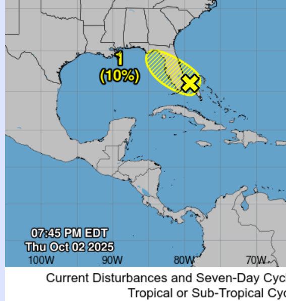
Unfortunately you are correct, and I remember someone mentioning the home brew part of the season is up next and it looks like it may have begun. These storms seem to be originating in odd places lately. And then there is this nasty storm, I really appreciate that the employees at the NHC will keep working even though they won't be paid during the shutdown. Humans, especially most decision makers, are really peculiar and I will never understand them.