All Activity
- Past hour
-

Spooky Season (October Disco Thread)
ineedsnow replied to Prismshine Productions's topic in New England
You got to admit that was a big shift -
Definitely making the turn

-

Spooky Season (October Disco Thread)
dryslot replied to Prismshine Productions's topic in New England
Same family though, Yes? -
I think they don’t want to die unless absolutely driven inland
-

Spooky Season (October Disco Thread)
dendrite replied to Prismshine Productions's topic in New England
Two different things. Pawpaws are native to north america/ontario and are hardy to zone 4. -

Spooky Season (October Disco Thread)
MJO812 replied to Prismshine Productions's topic in New England
In December -
It’s a mythical veteran’s day storm lol .
-

Mid to long range discussion- 2025
WinstonSalemArlington replied to wncsnow's topic in Southeastern States
November 10 (for entertainment purposes only) -
This week's system is still evolving, I see a dryslot
-
This is such a Mike Elias hire.... He may end up really good but I've never heard of him as I think most people have not. This seems like Elias wanting a yes man and not someone that's been a manager before and willing to push back on Elias.
-

2025-2026 ENSO
brooklynwx99 replied to 40/70 Benchmark's topic in Weather Forecasting and Discussion
we might as well mention the cooling of the majority of the N PAC basin, especially near Japan and SW of the Aleutian Islands
-

Spooky Season (October Disco Thread)
CoastalWx replied to Prismshine Productions's topic in New England
They'll be none. -

Central PA Fall Discussions and Obs
WmsptWx replied to ChescoWx's topic in Upstate New York/Pennsylvania
Makes sense. People with that name are usually pretty rough lol. -

Spooky Season (October Disco Thread)
Lava Rock replied to Prismshine Productions's topic in New England
Well that's not good: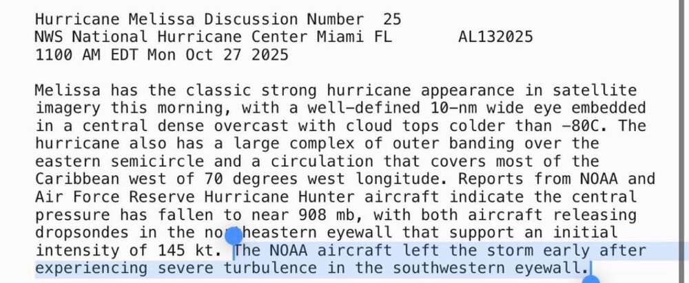
-
My goodness... https://bsky.app/profile/jeremydehartwx.bsky.social/post/3m46sngepdc2r
-
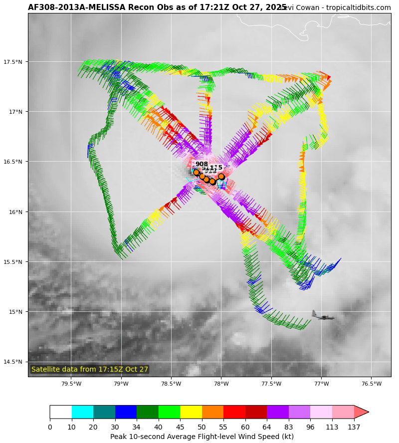
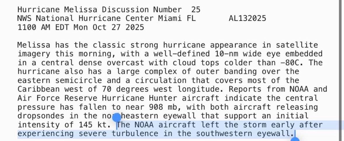
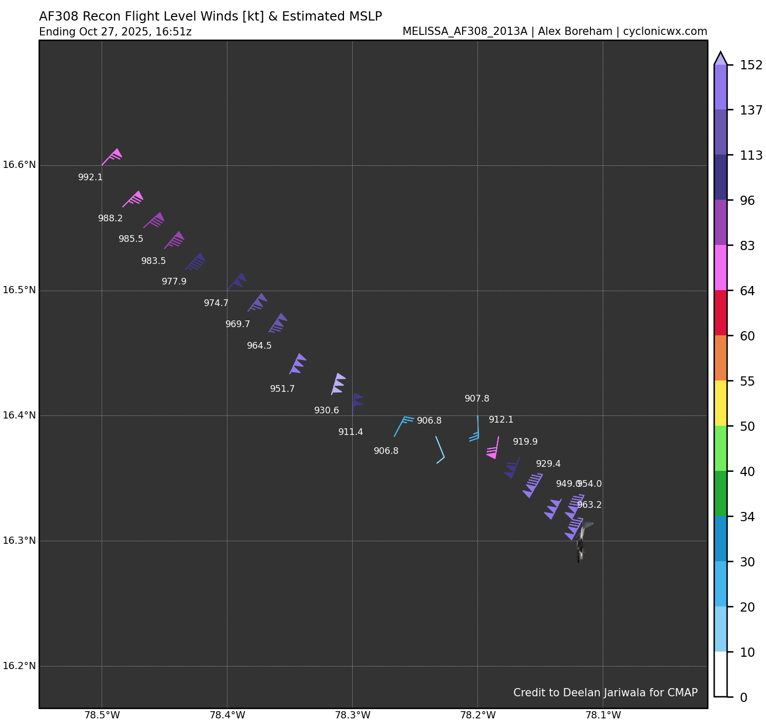
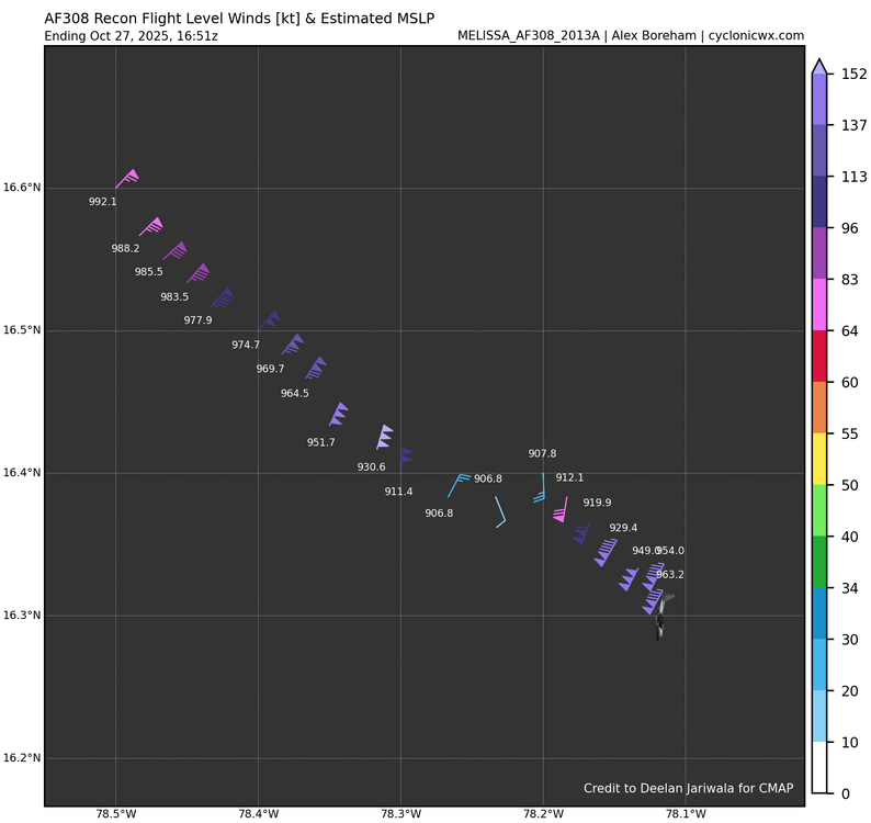
906mb in W/SW quadrant
-

Spooky Season (October Disco Thread)
Damage In Tolland replied to Prismshine Productions's topic in New England
Beers? -

Spooky Season (October Disco Thread)
bristolri_wx replied to Prismshine Productions's topic in New England
??????????????????????????????????????????????? -
Rainfall wise, the entire island is screwed which is the biggest killer in tropical systems. That portion will be pretty epic. The wind damage (at least the extreme portion of it) will likely be confined to the central and western end of the island.
-
We can really hammer this home. Best case scenario is the trough lifting Melissa out fast. Actually, this track has unfolded better that some of the model runs a few days ago that had the slow down and drift west we are seeing this morning occurring just off the southern coast in much closer proximity before turning inland. Hopefully, Melissa's core won't spend too much time over the island on Tuesday. It will still be a catastrophic impact, and mudflows off the ridges and down into low-lying areas is the most dangerous aspect of the event.
-
The rates will over come… Just prepared for days like today once we get into January Raw ass day today .
-
Low temp of 34 here this morning. A little frost, but those pole lima beans in the garden are amazing. They still look fine. I'll still be picking more over the next week. I'm thinking around November 4th is when the vegetable garden will finally be killed.
-
While they're still in the cone so still need to be cautious, it is looking good for Kingston from a wind perspective. Unfortunately they're still on the wet side and mudslides are devastating.
-
If an ERC happens, windfield expands. It’s almost fair to say the “best case scenario” from the wind and surge aspect is for Melissa to landfall with no ERC before landfall. If an ERC occurs, that tight window of Cat4/Cat5 5 winds will double or triple in size. Also, the storm surge would compound and grow higher.
-
The preliminary October 25 value of 15.03°C breaks the record of 15.01°C that was set just last year. It also ties last year's value for the latest 15°C or above mean temperature on record.