All Activity
- Past hour
-
Still no installs huh ?
-
Well ... ha, they'll miss whether the damn things 'll form. They tend to turn right of the environmental steering, because they are in fact drawn toward the better CAPE, and that's likelier S, where the cold pooling off the ongoing convection has organized into a meso or meso-beta scaled convectively induced cold front. This lifts lifts the environment, and the static stable layer over the top is forced to ascend to where it is no longer static, and that kicks off the propagation. The model physics hand that in principle. The GFS is in fact turning right ... the Euro and GGEM are driving it E through Maine. At this range, either is possible. The amount of turning right probably has some other factorization.
-
nice

-
Rain lightening up around here. Was a soaker though. Picked up 1.27” of rain (Still going a little bit) in 25 min or so. Intra-hour rates hit 3.8”/hr at one point. Temp dropped from 87 to 72 during the storm. Great storm! I’ll post my final temp and precip numbers this evening.
-
DTX looks to be at 100F, just about on Mon, I'll be 92F. Top tier lows during the weekend/Mon - so far showing 22C-24C. I'm looking forward to it!
-
Yeah. The mosquitoes have sucked today. No pun intended. Tried to do some work on the pool.
-
Justin Berk posted a video of a funnel cloud near Odenton. Definitely looks like it tried to form one.
-
73/70 OVC with shower approaching We swamp
-
Monday was almost totally clear and 80.
-
Congrats AllwetandallcoldATT. The blight on the tomato plants is running rampant. Just pulled a tomato of limbs off with it . And oh by the way the mosquitoes today .. unbearable
-
Well just got new tires down in Indy. Time to road test lol Sent from my SM-S134DL using Tapatalk
-
dogs living with cats, real biblical stuff. meanwhile, I thought it was supposed to be rainy all day. just hit 90f by my office in the bronx.
-
if you look at this loop, literally over just the last 1/2 hour or so, all of NE PA/E NY, W MA and W CT just went more sun than clouds. My guess is the warm front is mixing out. It's 76/70 here up from 73/66 and hour ago, and though we're in the clouds its noticeably jumped.
-
Don't models tend to poorly handle MCS propagation, especially in these regimes? Models in general though seem to struggle with how convection behaves when you have sharp instability gradients. In real time the convection will follow the instability axis but models tend to place a greater emphasis on other variables. Anyways look at the GFS and where it tracks the MCS then look at MUCAPE...if we were to fast forward to verification time my bet would be the MCS making a sharp turn across southwestern NY into PA.
-
Blue sky starting to peak thru now. Big rainer mostly.
-
And just like that. The sun comes out and dewpoints into the 70s. Feels like summer.
-
Completely off topic but if your interested in Artificial intelligence and comedy, this is ai comedy gold. Don't miss the fight. https://youtu.be/9HJZYjkNs_s?si=tu5IAGTfGPQ5ZFuB
-
Good post. Although I do disagree with this part: "While at this juncture it doesn't look like record highs are in jeopardy..." Below, is the current point-click forecast centered on DTW Airport. Record highs for Saturday through Tuesday are: 96, 98, 95, and 97. Record high minima are: 75, 73, 74, and 74. So this forecast would imply a new record high on Monday, June 23, and record high minima on Sunday, Monday, and Tuesday (tie). So I don't agree with that conclusion. Clearly, records are in jeopardy or else the NWS forecast is out to lunch. And this is just one location. I'm sure other locations will be at or near record high temperatures as well.
-
77/72 with BINOVC. AWT.
-
there's goes our boating day.
-
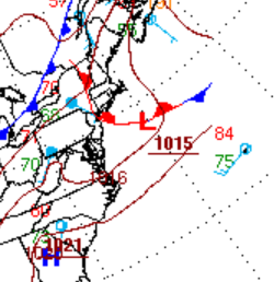
you actually beat us ... Why you sumna bish ... Yeah, judging by this cut out of WPC's "always" trustworthy never odd looking computer generated frontal tapestry ... ( haha) that we're getting the old end-around warm frontal passage - it's likely through you guys up there and we're getting quasi nut pinched down here.
-
Well ... what do you mean by that - the models are tracking where they see it. How do we know where that axis will be at this time. In principle, that's true. They'll pac-man along the elevated thermodynamic gradient.
-
My initial wondering/thinking is whether the models are too far northeast with the MCS. Verbatim I am wondering if this would track to our southwest as that is where the instability gradient is most defined.
-
Wow, that line/system looks quite intense. Have to wonder if it will reach derecho criteria.
-
85/68 up here at MVL. What a summer day today.


.thumb.jpg.6a4895b2a43f87359e4e7d04a6fa0d14.jpg)


