All Activity
- Past hour
-

September 2025 OBS-Discussion centered NYC subforum
Sundog replied to wdrag's topic in New York City Metro
The difference is the crysophere can still be in place in large swaths of Canada in April whereas it's nowhere to be found in mid September unless you're on the Arctic Ocean. -
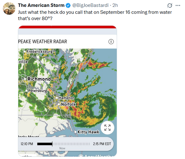
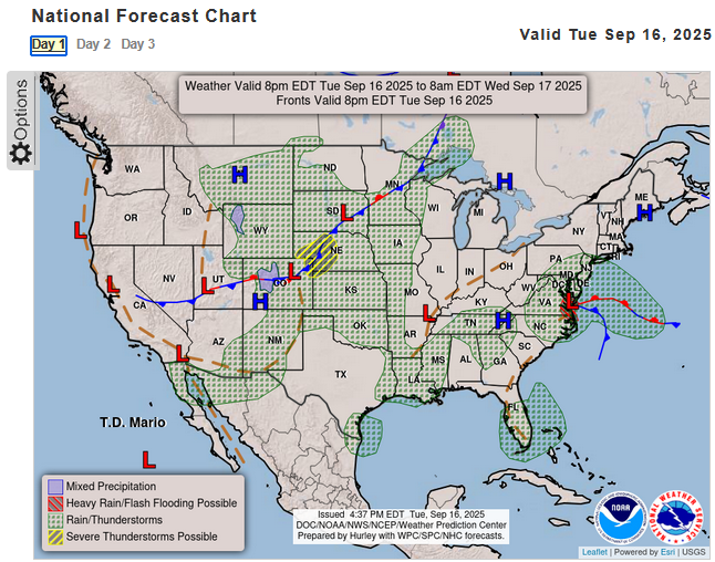
Joe Bastardi is arguing that the current nor'easter that has dumped more than 3" of rain at Norfolk over the past two days with gusts of 50 mph should be counted as a tropical cyclone: The flaw in his reasoning is that the system has fronts. Thus, it is not a tropical cyclone.
-
Missed here in 21057... just a little drizzle here and there today. .03 in the gauge.
-
I have relatives in Monument Beach and they were hit hard by the Cicada Brood XIV.
-

September 2025 OBS-Discussion centered NYC subforum
PhiEaglesfan712 replied to wdrag's topic in New York City Metro
Oddly enough, while that was happening, we were having the warmest September on record here. September 1881 remains the warmest September on record in some places, like PHL. But many places in the Eastern US had a snowstorm on April 19-20, 1983 (Boston May 9-10, 1977), which is a higher sun angle than September 16. -
No chance. Though I would love nothing more to be true
-
This dry hot period has turned into a wet few days with very comfortable temperatures. Had rain last night and a line of storms coming through now. Temps in the upper 60s and 70s have been perfect. Today's high was 71 with a current temp of 68 with rain.
-
2025-2026 ENSO
PhiEaglesfan712 replied to 40/70 Benchmark's topic in Weather Forecasting and Discussion
Yeah, a 1949-50 or 2022-23 snowless type season is not out of the question. Some places could even set a new record low for the least snowy 10-year period in 2025-26. For example, PHL would break the record (set from 1922-23 through 1931-32) with less than 13.4 inches of snow this upcoming winter. -
Real rain falling here with a nice breeze. Windows open and so nice!
-
Thunder and lightning. Wasn’t expecting that!
-
Are you seeing 2022-2023 as a possible worst case scenario for the upcoming winter? I thought pulling such a snowless winter would be impossible but it seems we are in a record ultra low snow multiyear pattern...
-
2025-2026 ENSO
PhiEaglesfan712 replied to 40/70 Benchmark's topic in Weather Forecasting and Discussion
We had a repeat in 2002-03 through 2004-05. 02-03 was a blockbuster winter, 03-04 was cold, and 04-05 had above average snowfall. -
Headed to Dulles. Not a drop of rain. Maybe leaving gives a better shot at it tomorrow. My garden is dead anyway.
-

2025-2026 ENSO
michsnowfreak replied to 40/70 Benchmark's topic in Weather Forecasting and Discussion
Sounds good to me. A winter closer to 20th coldest instead of top 5 and with snowfall well over 100". Book it! -
CC says it's sleet
-
Interesting. Sept 1881 is the hottest on record at Detroit. Heavy rain did fall on 9/16, 1.38", with a high of 72F.
-

September 2025 OBS-Discussion centered NYC subforum
Brian5671 replied to wdrag's topic in New York City Metro
looks like a tropical or subtropical storm off the VA capes -

September 2025 OBS-Discussion centered NYC subforum
donsutherland1 replied to wdrag's topic in New York City Metro
A strong nor'easter was bringing gusty winds and heavy rain to parts of the Middle Atlantic region late this afternoon. Through 4 pm, Norfolk had picked up 2.14" of rain. The wind has gusted to 44 mph there. This storm will bring some showers and periods of rain tomorrow into Thursday. The Delmarva and Jersey Shore will see the heaviest amounts. There, 1.00" or above amounts are likely. The temperature will top out in the upper 60s to lower 70s tomorrow. Readings will likely return to the upper 70s on Thursday and the lower 80s on Friday. Cooler air will return for the weekend. The ENSO Region 1+2 anomaly was -0.2°C and the Region 3.4 anomaly was -0.5°C for the week centered around September 10. For the past six weeks, the ENSO Region 1+2 anomaly has averaged +0.10°C and the ENSO Region 3.4 anomaly has averaged -0.37°C. La Niña conditions will likely develop during mid- or late-autumn. The SOI was -2.20 yesterday. The preliminary Arctic Oscillation (AO) was -1.002 today. Based on sensitivity analysis applied to the latest guidance, there is an implied near 56% probability that New York City will have a cooler than normal September (1991-2020 normal). September will likely finish with a mean temperature near 68.9° (0.3° below normal). Supplemental Information: The projected mean would be 0.9° above the 1981-2010 normal monthly value. -
We haven’t had any winter analogs in the last 10 years which matched anything prior to the 2015-2016 global temperature jump. So that would be the main reason that 2013-2014 analog would be unlikely in this much warmer climate. We saw the same effect following the smaller jump in global temperatures in 1997-1998. Since we are yet too see a 1993-1994 or 1995-1996 repeat in the years which followed. Same goes for a replay of the 1976-1977 and 1978-1979 winters after a smaller global temperature rise in 1983. So each new global temperature jump has prevented earlier analogs from before the jumps from occurring again. We would need a major volcanic eruption not seen in hundreds or thousands of years to have a shot at one of these winters again.
-
Up to 0.3” at DCA. Some good amounts up over .75” east of the Bay.
- Today
-
Borderline pouring in Greenbelt. Hoping that big orange blob holds together for Columbia.
-
She'll probably need to go at least 3 times before it's worth it. If it's that far it's a harder call IMO. Ellen-only day tix can be had for cheap sometimes, especially weekdays
-
It's the cicadas. None to speak of around here.
-
Looks like intensifying. Was this predicted?
-
I hope you had earmuffs and gloves as well.


